Login
Register


ANY
Anthony Municipal Airport
Official FAA Data Effective 2025-12-25 0901Z
Chart Supplement

VFR Chart of KANY
Sectional Charts at SkyVector.com
IFR Chart of KANY
Enroute Charts at SkyVector.com
Location Information for KANY
Coordinates: N37°9.59' / W98°4.77'Located 03 miles NW of Anthony, Kansas on 340 acres of land. View all Airports in Kansas.
Surveyed Elevation is 1343 feet MSL.
Operations Data
|
|
Airport Communications
| AWOS-3PT: | 119.575 Tel. 620-842-4345 |
|---|---|
| WICHITA APPROACH: | 126.7 353.5 |
| WICHITA DEPARTURE: | 126.7 353.5 |
| CTAF: | 122.800 |
| UNICOM: | 122.800 |
| AWOS-3P at K51 (23.3 W): | 119.625 620-886-3290 |
| AWOS-3PT at 9K8 (30.8 N): | 119.325 620-532-1272 |
| AWOS-3P at EGT (34.4 E): | 118.875 620-359-2156 |
Nearby Navigation Aids
|
| ||||||||||||||||||||||||||||||||||||||||||||||||||||||||||||


Runway 18/36
| Dimensions: | 5002 x 75 feet / 1525 x 23 meters | |
|---|---|---|
| Surface: | Concrete in Excellent Condition | |
| Weight Limits: | 11 /R/C/X/U | |
| Edge Lighting: | Low Intensity | |
| Runway 18 | Runway 36 | |
| Coordinates: | N37°10.05' / W98°4.74' | N37°9.23' / W98°4.75' |
| Elevation: | 1343.0 | 1335.2 |
| Traffic Pattern: | Left | Left |
| Runway Heading: | 180° True | 0 |
| Markings: | Non-Precision Instrument in fair condition. | Non-Precision Instrument in fair condition. |
| Glide Slope Indicator | P2L (3.00° Glide Path Angle) | P2L (3.00° Glide Path Angle) |
| Obstacles: | 34 ft Tree 894 ft from runway | |
Runway 10/28
| Dimensions: | 2212 x 60 feet / 674 x 18 meters MOWED 300 FT WIDE. | |
|---|---|---|
| Surface: | Turf in Good Condition SOFT AFTER RAIN. | |
| Runway 10 | Runway 28 | |
| Coordinates: | N37°9.53' / W98°5.06' | N37°9.44' / W98°4.61' |
| Elevation: | 1329.6 | 1339.0 |
| Traffic Pattern: | Left | Left |
| Runway Heading: | 104° True | 284° True |
| Markings: | None in fair condition. | None in fair condition. |
| Obstacles: | 5 ft Trees 111 ft from runway, 125 ft right of center | 13 ft Road 300 ft from runway, 155 ft right of center |
Services Available
| Fuel: | 100LL (blue) |
|---|---|
| Transient Storage: | Hangars,Tiedowns |
| Airframe Repair: | NOT AVAILABLE |
| Engine Repair: | NOT AVAILABLE |
| Bottled Oxygen: | NOT AVAILABLE |
| Bulk Oxygen: | NOT AVAILABLE |
| Other Services: | CROP DUSTING SERVICES |
Ownership Information
| Ownership: | Publicly owned | |
|---|---|---|
| Owner: | CITY OF ANTHONY | |
| 124 S BLUFF, P O BOX 504 | ||
| ANTHONY, KS 67003 | ||
| 620-842-5434 | ||
| Manager: | CYNDRA KASTENS | |
| 124 S BLUFF, P O BOX 504 | ||
| ANTHONY, KS 67003 | ||
| 620-842-5434 | ||
Other Remarks
- TERMINAL BLDG ACCESS CODE 134.
- FOR CD IF UNA TO CTC ON FSS FREQ, CTC WICHITA APPCH AT 316-350-1520
- 0LL FUEL SELF SVC.
- LIRL RWY 18/36 PRESET LOW INTST; TO INCR INTST AND ACTVT PAPI RWY 18 & 36 - CTAF.
Weather Minimums
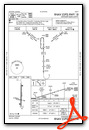
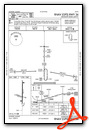
Instrument Approach Procedure (IAP) Charts
Nearby Airports with Instrument Procedures
| ID | Name | Heading / Distance | ||
|---|---|---|---|---|
 |
8K2 | Harper Municipal Airport | 013° | 7.3 |
|
O53 | Medford Municipal Airport | 144° | 27.2 |
|
9K8 | Kingman/Clyde Cessna Field Airport | 356° | 30.6 |
|
KEGT | Wellington Municipal Airport | 073° | 34.6 |
|
KAVK | Alva Regional Airport | 231° | 36.7 |
|
KICT | Wichita Dwight D Eisenhower Ntl Airport | 046° | 42.6 |
|
KBKN | Blackwell-Tonkawa Municipal Airport | 125° | 43.0 |
|
KPTT | Pratt Regional Airport | 315° | 45.6 |
|
KIAB | Mc Connell AFB Airport | 054° | 47.7 |
|
KWDG | Enid Woodring Regional Airport | 163° | 49.0 |
|
KCEA | Cessna Acft Field Airport | 053° | 49.3 |
|
K50 | Cook Airfield Airport | 060° | 49.6 |
Airport Images
Do you have a recent image of this airport? Upload it here!


Comments
Fuel price 6/7/2019 is $4.50
Fuel price 6/7/2019 is $4.50. Self serve only, no attendant. Courtesy car available. Lounge code is 134 (airport elevation/10).