Login
Register


BKN
Blackwell-Tonkawa Municipal Airport
Official FAA Data Effective 2025-11-27 0901Z
Chart Supplement

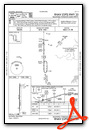
VFR Chart of KBKN
Sectional Charts at SkyVector.com
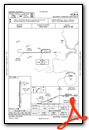
IFR Chart of KBKN
Enroute Charts at SkyVector.com
Location Information for KBKN
Coordinates: N36°44.71' / W97°20.97'Located 05 miles SW of Blackwell, Oklahoma on 231 acres of land. View all Airports in Oklahoma.
Surveyed Elevation is 1030 feet MSL.
Operations Data
|
|
Airport Communications
| AWOS-3PT: | 120.575 Tel. 580-363-0688 |
|---|---|
| CTAF: | 122.800 |
| UNICOM: | 122.800 |
| ASOS at PNC (12.0 E): | 134.075 580-765-0049 |
| ASOS at WLD (29.5 NE): | 118.025 620-221-9121 |
| AWOS-3PT at WDG (30.6 SW): | 123.725 580-237-1475 |
- APCH/DEP CTL SVC PRVDD BY KANSAS CITY ARTCC (ZKC) ON FREQS 127.8/319.1 (PONCA CITY RCAG).
Nearby Navigation Aids
|
| ||||||||||||||||||||||||||||||||||||||||||||||||||||||||||||


Runway 17/35
| Dimensions: | 3501 x 60 feet / 1067 x 18 meters | |
|---|---|---|
| Surface: | Asphalt in Excellent Condition | |
| Weight Limits: | S-30, D-48, ST-98 | |
| Edge Lighting: | Medium Intensity | |
| Runway 17 | Runway 35 | |
| Coordinates: | N36°45.00' / W97°20.98' | N36°44.42' / W97°20.97' |
| Elevation: | 1030.0 | 1009.3 |
| Traffic Pattern: | Left | Left |
| Runway Heading: | 180° True | 360° True |
| Markings: | Non-Precision Instrument in good condition. | Non-Precision Instrument in good condition. |
| Glide Slope Indicator | P2L (3.00° Glide Path Angle) | P2L (3.00° Glide Path Angle) |
Services Available
| Fuel: | 100LL (blue) |
|---|---|
| Transient Storage: | Hangars,Tiedowns |
| Airframe Repair: | NONE |
| Engine Repair: | NONE |
| Bottled Oxygen: | NONE |
| Bulk Oxygen: | NONE |
| Other Services: | CROP DUSTING SERVICES |
Ownership Information
| Ownership: | Publicly owned | |
|---|---|---|
| Owner: | CITIES OF BLACKWELL/TONKAWA | |
| 16705 W. HUBBARD ROAD | ||
| BLACKWELL, OK 74631 | ||
| 580-363-4242 | ||
| Manager: | DENNIS PEARCE | |
| 16705 W. HUBBARD ROAD | ||
| BLACKWELL, OK 74631 | ||
| 580-363-4242 | ||
Other Remarks
- THIS AIRPORT HAS BEEN SURVEYED BY THE NATIONAL GEODETIC SURVEY.
- FOR CD CTC KANSAS CITY ARTCC AT 913-254-8508.
- ARPT LCTD 5 MILES SW BLACKWELL; 5 MILES NW TONKAWA.
- 0LL FUEL AVBL 24 HRS THRU AUTOMATED CREDIT CARD SYSTEM.
- ACTVT & INCR INTST MIRL RWY 17/35 - CTAF. PAPI RWY 17 & 35 ON CONSLY.
Weather Minimums


Instrument Approach Procedure (IAP) Charts

Nearby Airports with Instrument Procedures
| ID | Name | Heading / Distance | ||
|---|---|---|---|---|
 |
KPNC | Ponca City Regional Airport | 093° | 12.1 |
|
O53 | Medford Municipal Airport | 278° | 19.4 |
|
F22 | Perry Municipal Airport | 170° | 21.8 |
|
KWLD | Strother Field Airport | 030° | 29.5 |
|
KWDG | Enid Woodring Regional Airport | 223° | 30.7 |
|
KEGT | Wellington Municipal Airport | 356° | 34.8 |
|
KEND | Vance AFB Airport | 228° | 36.6 |
|
KSWO | Stillwater Regional Airport | 159° | 37.2 |
|
KANY | Anthony Municipal Airport | 305° | 43.0 |
|
8K2 | Harper Municipal Airport | 313° | 46.2 |
|
K50 | Cook Airfield Airport | 009° | 49.9 |
|
KIAB | Mc Connell AFB Airport | 004° | 52.8 |
Airport Images

By: reeset72


