Login
Register


K50
Cook Airfield Airport
Official FAA Data Effective 2026-02-19 0901Z
Chart Supplement

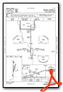
VFR Chart of K50
Sectional Charts at SkyVector.com
IFR Chart of K50
Enroute Charts at SkyVector.com
Location Information for K50
Coordinates: N37°33.92' / W97°10.48'Located 02 miles W of Rose Hill, Kansas on 55 acres of land. View all Airports in Kansas.
Estimated Elevation is 1342 feet MSL.
Operations Data
|
|
Airport Communications
| WICHITA APPROACH: | 134.8 269.1 |
|---|---|
| WICHITA DEPARTURE: | 134.8 269.1 |
| UNICOM: | 122.800 |
| CTAF: | 122.800 |
| D-ATIS at IAB (5.6 NW): | 269.9 |
| AWOS-3P at 3AU (7.9 NE): | 124.175 316-733-6696 |
| AWOS-3PT at BEC (8.0 N): | 119.45 316-515-7116 |
Nearby Navigation Aids
|
| ||||||||||||||||||||||||||||||||||||||||||||||||||||||||||||


Runway 17/35
| Dimensions: | 3471 x 40 feet / 1058 x 12 meters | |
|---|---|---|
| Surface: | Asphalt in Good Condition | |
| Weight Limits: | S-2 | |
| Edge Lighting: | Medium Intensity | |
| Runway 17 | Runway 35 | |
| Coordinates: | N37°34.20' / W97°10.50' | N37°33.63' / W97°10.50' |
| Elevation: | 1336.0 | 1336.0 |
| Traffic Pattern: | Left | Right |
| Displaced Threshold: | 198 Feet | |
| Markings: | Basic in good condition. | Basic in good condition. |
| Glide Slope Indicator | P2L (3.50° Glide Path Angle) | P2L (3.00° Glide Path Angle) |
| Obstacles: | 36 ft Trees 200 ft from runway, 65 ft right of center OBSTN CLNC SLOPE 0:1 TO DTHR OVR 25 FT HGR, 50 FT DSTC, 130 FT R. 30 FT TREES, 90 FT DSTC, 100 FT R. |
15 ft Road 255 ft from runway, 130 ft left of center |
Runway 01/19
| Dimensions: | 1600 x 50 feet / 488 x 15 meters | |
|---|---|---|
| Surface: | Turf in Good Condition | |
| Runway 01 | Runway 19 | |
| Coordinates: | N37°33.81' / W97°10.49' | N37°34.06' / W97°10.39' |
| Elevation: | 1341.5 | 1329.9 |
| Traffic Pattern: | Left | Left |
| Obstacles: | 25 ft Hangar 235 ft from runway, 150 ft left of center | 30 ft Tree 63 ft from runway, 93 ft right of center |
Services Available
| Fuel: | 100LL (blue), Automotive Gasoline |
|---|---|
| Transient Storage: | Tiedowns |
| Airframe Repair: | NONE |
| Engine Repair: | NONE |
| Bottled Oxygen: | NONE |
| Bulk Oxygen: | NONE |
Ownership Information
| Ownership: | Privately Owned | |
|---|---|---|
| Owner: | CROSSWINDS AVIATION INC. | |
| 7015 S 143 RD ST E, DERBY, KS, P.O. BOX 574 | ||
| ROSE HILL, KS 67133 | ||
| 316-706-6131 | GTHOMAS81@HOTMAIL.COM | |
| Manager: | STEVE LOGUE | CO-MANAGER GREG THOMAS |
| 6841 S.143RD | ||
| DERBY, KS 67037 | ||
| 316-706-6131 | CO-MANAGER PHONE 316-650-6581. | |
Other Remarks
- FOR CD CTC WICHITA APCH AT 316-350-1520.
- RWY 17 CLNC SLOPE 21:1 TO 190 FT DSPLCD THLD.
- 0LL FUEL SELF-SVC.
- ACTVT PAPI RWY 17 & 35; MIRL RWY 17/35 - 123.5.
Weather Minimums

Instrument Approach Procedure (IAP) Charts
Nearby Airports with Instrument Procedures
| ID | Name | Heading / Distance | ||
|---|---|---|---|---|
 |
KIAB | Mc Connell AFB Airport | 307° | 5.6 |
|
KCEA | Cessna Acft Field Airport | 324° | 6.2 |
|
3AU | Augusta Municipal Airport | 036° | 7.8 |
|
KBEC | Beech Factory Airport | 346° | 7.9 |
|
KAAO | Colonel James Jabara Airport | 348° | 11.1 |
|
1K1 | Lloyd Stearman Field Airport | 013° | 12.9 |
|
KICT | Wichita Dwight D Eisenhower Ntl Airport | 292° | 13.3 |
|
KEGT | Wellington Municipal Airport | 215° | 17.7 |
|
KEQA | El Dorado/Capt Jack Thomas Memorial Airport | 053° | 21.1 |
|
KWLD | Strother Field Airport | 164° | 24.7 |
|
KEWK | Newton-City-County Airport | 350° | 29.9 |
|
47K | Moundridge Municipal Airport | 338° | 41.6 |
Airport Images
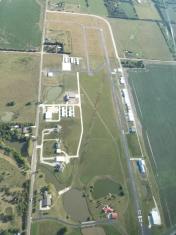
By: gthomas81@hotma...


