Login
Register


FWB
Branson West Municipal/Emerson Field Airport
Official FAA Data Effective 2025-12-25 0901Z
Chart Supplement

VFR Chart of KFWB
Sectional Charts at SkyVector.com
IFR Chart of KFWB
Enroute Charts at SkyVector.com
Location Information for KFWB
Coordinates: N36°41.91' / W93°24.13'Located 02 miles W of Branson West, Missouri on 303 acres of land. View all Airports in Missouri.
Surveyed Elevation is 1348 feet MSL.
Operations Data
|
|
Airport Communications
| AWOS-3PT: | 119.725 Tel. 417-272-3922 |
|---|---|
| SPRINGFIELD APPROACH: | 126.35 |
| SPRINGFIELD DEPARTURE: | 126.35 |
| UNICOM: | 123.000 |
| CTAF: | 123.000 |
| ATIS at BBG (13.9 SE): | 124.625 |
| AWOS-2 at BBG (13.9 SE): | 124.625 417-334-0218 |
| ASOS at HRO (28.8 SE): | 121.125 870-365-8550 |
Nearby Navigation Aids
|
| ||||||||||||||||||||||||||||||||||||||||||||||||


Runway 03/21
| Dimensions: | 5002 x 75 feet / 1525 x 23 meters | |
|---|---|---|
| Surface: | Concrete in Excellent Condition | |
| Weight Limits: | S-30 | |
| Edge Lighting: | Medium Intensity | |
| Runway 03 | Runway 21 | |
| Coordinates: | N36°41.58' / W93°24.44' | N36°42.24' / W93°23.83' |
| Elevation: | 1290.8 | 1348.1 |
| Traffic Pattern: | Right | |
| Runway Heading: | 36° True | 216° True |
| Markings: | Non-Precision Instrument in good condition. | Non-Precision Instrument in good condition. |
| Glide Slope Indicator | P4R (3.00° Glide Path Angle) | P4L (3.30° Glide Path Angle) |
| REIL: | Yes | Yes |
Services Available
| Fuel: | 100LL (blue), Jet-A |
|---|---|
| Transient Storage: | Hangars,Tiedowns |
| Airframe Repair: | MINOR |
| Engine Repair: | MINOR |
| Bottled Oxygen: | LOW |
| Bulk Oxygen: | NONE |
| Other Services: | PILOT INSTRUCTION,AIRCRAFT RENTAL |
Ownership Information
| Ownership: | Publicly owned | |
|---|---|---|
| Owner: | CITY OF BRANSON WEST | |
| P.O. BOX 2229 | ||
| BRANSON WEST, MO 65737 | ||
| 417-272-3313 | ||
| Manager: | CITY OF BRANSON WEST | |
| 393 AERO DRIVE | ||
| BRANSON WEST, MO 65737 | ||
| 417-272-3921 | ||
Other Remarks
- FOR CD CTC SPRINGFIELD APCH AT 417-868-5620/5619.
- 0LL SELF SVC 100LL AVBL WITH CREDIT CARD 24 HRS.
- ACTVT MIRL RWY 03/21 AND REIL RWY 03 & RWY 21 - CTAF; PAPIS RWY 03 AND RWY 21-OPER CONTINUOUSLY.
Weather Minimums
Instrument Approach Procedure (IAP) Charts
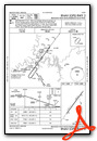
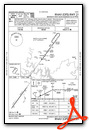
Nearby Airports with Instrument Procedures
| ID | Name | Heading / Distance | ||
|---|---|---|---|---|
 |
KPLK | M Graham Clark Downtown Airport | 117° | 9.4 |
|
KBBG | Branson Airport | 135° | 13.9 |
|
2H2 | Jerry Sumners Sr Aurora Municipal Airport | 318° | 21.2 |
|
4M1 | Carroll County Airport | 209° | 21.8 |
|
94K | Cassville Municipal Airport | 269° | 24.0 |
|
KHRO | Boone County Airport | 155° | 28.8 |
|
KHFJ | Monett Regional Airport | 292° | 32.0 |
|
3DW | Downtown Airport | 013° | 32.3 |
|
KSGF | Springfield-Branson Ntl Airport | 001° | 32.8 |
|
KAOV | Ava Bill Martin Memorial Airport | 064° | 38.4 |
|
KROG | Rogers Exec - Carter Field Airport | 240° | 39.3 |
|
H34 | Huntsville Municipal Airport | 204° | 40.9 |
Airport Images

By: val.foreit
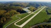
By: bwjetcenter


Comments
Branson West - Holiday
It looked like a nice place, but don't plan a stop there on a holiday. I could get inside to use the restroom, but that's it. There was a sign to "Vending Machines" but the doors were locked. Not even a water fountain was available, I guess it must be in the locked room with the vending machines. Two other pilots were there looking for a courtesy car, no-one around to ask. No Uber available that day either. Might be just fine on a normal workday, but I don't recommend it on a holiday.