Login
Register


BEA
Beeville Municipal Airport
Official FAA Data Effective 2026-01-22 0901Z
Chart Supplement

VFR Chart of KBEA
Sectional Charts at SkyVector.com
IFR Chart of KBEA
Enroute Charts at SkyVector.com
Location Information for KBEA
Coordinates: N28°21.85' / W97°47.52'Located 03 miles SW of Beeville, Texas on 391 acres of land. View all Airports in Texas.
Surveyed Elevation is 272 feet MSL.
Operations Data
|
|
Airport Communications
| AWOS-3: | 118.675 Tel. 361-362-7627 |
|---|---|
| UNICOM: | 122.800 |
| CTAF: | 122.800 |
| AWOS-3PT at 8T6 (17.2 W): | 119.05 361-449-1119 |
| ASOS at NGT (17.6 NE): | 353.675 |
| AWOS-3 at T69 (23.5 SE): | 118.25 361-364-1844 |
- APCH/DEP CTL SVC PRVDD BY HOUSTON ARTCC (ZHU) ON FREQS 134.6/322.5 (THREE RIVERS RCAG).
Nearby Navigation Aids
|
| ||||||||||||||||||||||||||||||||||||||||||


Runway 12/30
| Dimensions: | 4553 x 75 feet / 1388 x 23 meters | |
|---|---|---|
| Surface: | Asphalt in Good Condition | |
| Weight Limits: | S-25 | |
| Edge Lighting: | Medium Intensity | |
| Runway 12 | Runway 30 | |
| Coordinates: | N28°21.96' / W97°47.78' | N28°21.47' / W97°47.14' |
| Elevation: | 268.2 | 244.0 |
| Traffic Pattern: | Left | Left |
| Runway Heading: | 131° True | 311° True |
| Markings: | Non-Precision Instrument in good condition. | Non-Precision Instrument in good condition. |
| Glide Slope Indicator | P2L (3.00° Glide Path Angle) | P2L (3.00° Glide Path Angle) |
| Obstacles: | 15 ft Road 260 ft from runway, 260 ft right of center ALSO 30 FT PLINE, 464 FT DSTC, 295 FT R, OBSTN CLNC SLOPE 8:1. ALSO 30 FT PLINE, 445 FT DSTC, 290 FT R, OBSTN CLNC SLOPE 8:1. |
15 ft Road 258 ft from runway, 264 ft left of center |
Runway 18/36
| Dimensions: | 2251 x 60 feet / 686 x 18 meters | |
|---|---|---|
| Surface: | Turf in Good Condition | |
| Runway 18 | Runway 36 | |
| Coordinates: | N28°22.32' / W97°47.59' | N28°21.95' / W97°47.66' |
| Elevation: | 272.3 | 265.2 |
| Runway Heading: | 189° True | 9° True |
| Obstacles: | 20 ft Power Line 450 ft from runway, 200 ft right of center | 21 ft Power Line 675 ft from runway, 180 ft left of center |
Services Available
| Fuel: | 100LL (blue), Jet A+ |
|---|---|
| Transient Storage: | Tiedowns |
| Airframe Repair: | MINOR |
| Engine Repair: | MINOR |
| Bottled Oxygen: | NONE |
| Bulk Oxygen: | NONE |
Ownership Information
| Ownership: | Publicly owned | |
|---|---|---|
| Owner: | CITY OF BEEVILLE | |
| 400 N. WASHINGTON | ||
| BEEVILLE, TX 78102 | ||
| 361-358-4641 | ||
| Manager: | JOHN BENSON | |
| 400 N. WASHINGTON | ||
| BEEVILLE, TX 78102 | ||
| 361-358-4641 | AMGR CELL: 361-742-7725 | |
Other Remarks
- FOR CD CTC HOUSTON ARTCC AT 281-230-5622.
- ON SITE ATTENDANT TIM FITCH, TIMAFITCH@GMAIL.COM, 361-319-3448. ALSO LARRY CLINE 361-542-6544.
- MKD WITH 3 FT YELLOW CONES.
- 0LL FUEL 24 HR SELF SERV.
- SS-SR MIRL RY 12/30 PRESET LOW INTST; TO INCR INTST ACTVT - CTAF.
Weather Minimums

Instrument Approach Procedure (IAP) Charts
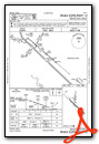
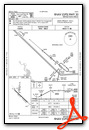
Nearby Airports with Instrument Procedures
| ID | Name | Heading / Distance | ||
|---|---|---|---|---|
 |
TX2 | Chase Field Industrial Airport | 090° | 6.9 |
|
8T6 | Live Oak County Airport | 269° | 17.2 |
|
T69 | Sinton Airport | 145° | 23.6 |
|
2R9 | Kenedy Regional Airport | 351° | 27.8 |
|
KNOG | Orange Grove Nalf Airport | 205° | 31.0 |
|
KRBO | Nueces County Airport | 171° | 35.5 |
|
KCRP | Corpus Christi International Airport | 156° | 38.6 |
|
KALI | Alice International Airport | 198° | 39.3 |
|
KTFP | Ingleside Regional Airport | 131° | 41.0 |
|
KRKP | Aransas County Airport | 112° | 43.0 |
|
KNGP | Corpus Christi NAS (Truax Field) Airport | 146° | 48.2 |
|
KRAS | Mustang Beach Airport | 131° | 49.9 |
Airport Images

By: deeringdeluxe


