Login
Register


TFP
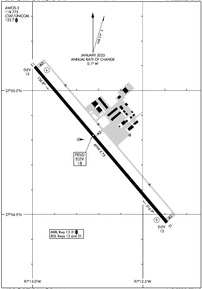
Ingleside Regional Airport
Official FAA Data Effective 2026-02-19 0901Z
Chart Supplement

KTFP Airport Diagram
VFR Chart of KTFP
Sectional Charts at SkyVector.com
IFR Chart of KTFP
Enroute Charts at SkyVector.com
Location Information for KTFP
Coordinates: N27°54.78' / W97°12.69'Located 02 miles N of Ingleside, Texas on 231 acres of land. View all Airports in Texas.
Surveyed Elevation is 17 feet MSL.
Operations Data
|
|
Airport Communications
| AWOS-3: | 118.775 Tel. 361-758-8961 |
|---|---|
| CORPUS APPROACH: | 120.9 348.725 |
| CORPUS DEPARTURE: | 120.9 348.725 |
| CTAF: | 122.700 |
| UNICOM: | 122.700 |
| AWOS-3 at RAS (9.2 SE): | 118.425 361-749-0537 |
| ASOS at RKP (13.7 NE): | 119.275 361-729-2372 |
| ATIS at NGP (13.9 S): | 127.9 |
Nearby Navigation Aids
|
| ||||||||||||||||||||||||||||||||||||


Runway 13/31
| Dimensions: | 4999 x 75 feet / 1524 x 23 meters | |
|---|---|---|
| Surface: | Asphalt in Good Condition | |
| Edge Lighting: | Medium Intensity | |
| Runway 13 | Runway 31 | |
| Coordinates: | N27°55.10' / W97°12.99' | N27°54.47' / W97°12.39' |
| Elevation: | 15.0 | 13.2 |
| Runway Heading: | 140° True | 320° True |
| Markings: | Non-Precision Instrument in good condition. | Non-Precision Instrument in good condition. |
| Glide Slope Indicator | P2L (3.00° Glide Path Angle) | P2L (3.00° Glide Path Angle) |
| REIL: | Yes | Yes |
Services Available
| Fuel: | 100LL (blue), Jet A+ |
|---|---|
| Transient Storage: | Hangars,Tiedowns |
| Airframe Repair: | MAJOR |
| Engine Repair: | MAJOR |
| Bottled Oxygen: | NOT AVAILABLE |
| Bulk Oxygen: | NOT AVAILABLE |
| Other Services: | PILOT INSTRUCTION |
Ownership Information
| Ownership: | Publicly owned | |
|---|---|---|
| Owner: | SAN PATRICIO COUNTY | |
| 400 WEST SINTON ST. | ||
| SINTON, TX 78387 | ||
| 361-364-9303 | ||
| Manager: | GARY LEE DAVIS | |
| 3141 FM 3512 | ||
| ARANSAS PASS, TX 78336 | ||
| 361-226-0112 | 317-410-0724 | |
Other Remarks
- FOR CD CTC CORPUS CHRISTI APCH AT 361-299-4230.
- NORTH END OF RWY CNTRLN MKG POOR.
- 0LL FUEL: FULL SERV & SELF SERVE.
- MIRL RWY 13/31 PRESET LOW INTST; TO INCR INTST ACTVT - CTAF.
Weather Minimums

Instrument Approach Procedure (IAP) Charts


Nearby Airports with Instrument Procedures
| ID | Name | Heading / Distance | ||
|---|---|---|---|---|
 |
KRAS | Mustang Beach Airport | 132° | 8.9 |
|
KRKP | Aransas County Airport | 040° | 13.7 |
|
KNGP | Corpus Christi NAS (Truax Field) Airport | 197° | 13.8 |
|
KCRP | Corpus Christi International Airport | 241° | 17.6 |
|
T69 | Sinton Airport | 293° | 19.1 |
|
KRBO | Nueces County Airport | 252° | 26.7 |
|
TX2 | Chase Field Industrial Airport | 318° | 36.0 |
|
KNQI | Kingsville NAS Airport | 232° | 40.1 |
|
KBEA | Beeville Municipal Airport | 311° | 40.9 |
|
KNOG | Orange Grove Nalf Airport | 268° | 44.2 |
|
KALI | Alice International Airport | 256° | 44.6 |
|
KIKG | Kleberg County Airport | 243° | 48.7 |
Airport Images
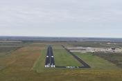
By: grz885


