Login
Register


8T6
Live Oak County Airport
Official FAA Data Effective 2026-01-22 0901Z
Chart Supplement

VFR Chart of 8T6
Sectional Charts at SkyVector.com
IFR Chart of 8T6
Enroute Charts at SkyVector.com
Location Information for 8T6
Coordinates: N28°21.77' / W98°6.99'Located 02 miles N of George West, Texas on 132 acres of land. View all Airports in Texas.
Surveyed Elevation is 128 feet MSL.
Operations Data
|
|
Airport Communications
| AWOS-3PT: | 119.05 Tel. 361-449-1119 |
|---|---|
| CTAF: | 122.900 |
| AWOS-3 at BEA (17.0 E): | 118.675 361-362-7627 |
| ATIS at NOG (28.2 S): | 254.35 |
| ASOS at NGT (30.5 NE): | 353.675 |
- APCH/DEP CTL SVC PRVDD BY HOUSTON ARTCC (ZHU) ON FREQS 134.6/322.5 (THREE RIVERS RCAG).
Nearby Navigation Aids
|
| ||||||||||||||||||||||||||||||||||||||||||||||||||||||


Runway 13/31
| Dimensions: | 3799 x 60 feet / 1158 x 18 meters | |
|---|---|---|
| Surface: | Asphalt in Excellent Condition | |
| Edge Lighting: | Medium Intensity | |
| Runway 13 | Runway 31 | |
| Coordinates: | N28°21.99' / W98°7.24' | N28°21.54' / W98°6.74' |
| Elevation: | 128.4 | 125.4 |
| Runway Heading: | 136° True | 316° True |
| Markings: | Non-Precision Instrument in fair condition. | Non-Precision Instrument in fair condition. |
| Glide Slope Indicator | P2L (3.00° Glide Path Angle) | P2L (3.00° Glide Path Angle) |
| Obstacles: | 50 ft Power Line 1361 ft from runway, 264 ft right of center | |
Services Available
| Fuel: | 100LL (blue), Jet-A |
|---|---|
| Transient Storage: | Tiedowns |
| Airframe Repair: | NOT AVAILABLE |
| Engine Repair: | NOT AVAILABLE |
| Bottled Oxygen: | NOT AVAILABLE |
| Bulk Oxygen: | NOT AVAILABLE |
Ownership Information
| Ownership: | Publicly owned | |
|---|---|---|
| Owner: | LIVE OAK COUNTY | |
| 301 HOUSTON ST, PO BOX 487 | ||
| GEORGE WEST, TX 78022 | ||
| 361-449-2733 | ||
| Manager: | JAMES LISKA | COUNTY JUDGE |
| 301 HOUSTON ST, PO BOX 487 | ||
| GEORGE WEST, TX 78022 | ||
| 361-449-8002 | ||
Other Remarks
- BIRDS ON & INVOF ARPT.
- FOR CD CTC HOUSTON ARTCC AT 281-230-5622.
- 75 FT ELEC TRANSMISSION LINE, 600 FT W OF AND PARL TO RWY CNTRLN, FULL LEN.
- FOR ASSISTANCE OR HNGR CALL 361-449-2559 OR 361-449-6315 (CELL).
- (CONTACT PHONE NR) LTDAVIS@LIVE.COM ALT 361-449-2093
- 0LL FUEL SELF-SERVE.
- DUSK-DAWN. MIRL RWY 13/31 PRESET LOW INTST; TO INCR INTST ACTVT - 122.7.
Weather Minimums

Instrument Approach Procedure (IAP) Charts
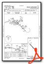
Nearby Airports with Instrument Procedures
| ID | Name | Heading / Distance | ||
|---|---|---|---|---|
 |
KBEA | Beeville Municipal Airport | 089° | 17.2 |
|
TX2 | Chase Field Industrial Airport | 089° | 24.1 |
|
KNOG | Orange Grove Nalf Airport | 172° | 28.2 |
|
2R9 | Kenedy Regional Airport | 025° | 30.7 |
|
T69 | Sinton Airport | 122° | 36.1 |
|
KALI | Alice International Airport | 172° | 37.5 |
|
KPEZ | Pleasanton Municipal Airport | 329° | 41.3 |
|
KRBO | Nueces County Airport | 147° | 41.7 |
|
KCRP | Corpus Christi International Airport | 137° | 48.1 |
|
KIKG | Kleberg County Airport | 174° | 48.8 |
|
KNQI | Kingsville NAS Airport | 162° | 53.9 |
|
KTFP | Ingleside Regional Airport | 119° | 55.0 |
Airport Images
Do you have a recent image of this airport? Upload it here!


