Login
Register


BKT
Allan C Perkinson/Blackstone AAF Airport
Official FAA Data Effective 2024-12-26 0901Z
Chart Supplement

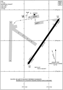
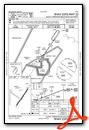
KBKT Airport Diagram
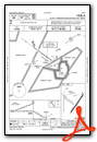
VFR Chart of KBKT
Sectional Charts at SkyVector.com
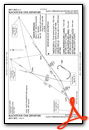
IFR Chart of KBKT
Enroute Charts at SkyVector.com
Location Information for KBKT
Coordinates: N37°4.48' / W77°57.11'Located 02 miles E of Blackstone, Virginia on 600 acres of land. View all Airports in Virginia.
Surveyed Elevation is 437 feet MSL.
Operations Data
|
|
Airport Communications
| ATIS: | 119.225 |
|---|---|
| ASOS: | Tel. 434-292-1400 |
| BLACKSTONE TOWER: | 134.7 292.7 |
| BLACKSTONE GROUND: | 127.625 |
| EMERG: | 121.5 243.0 |
| CTAF: | 134.700 |
| RANGE CTL: | 34.1 36.1 |
| AWOS-3 at W81 (9.5 NW): | 119.050 |
| AWOS-3 at W31 (13.1 SW): | 123.875 434-676-1078 |
| AWOS-3 at LVL (19.7 S): | 119.625 434-848-2017 |
- APCH/DEP SVC PRVDD BY WASHINGTON ARTCC ON FREQS 118.75/377.1(GREEN BAY RCAG).
Nearby Navigation Aids
|
| ||||||||||||||||||||||||||||||||||||||||||||||||||||||||||||


Runway 04/22
| Dimensions: | 5333 x 150 feet / 1625 x 46 meters | |
|---|---|---|
| Surface: | Concrete in Good Condition | |
| Weight Limits: | 51 /R/B/W/T | |
| Edge Lighting: | Medium Intensity | |
| Runway 04 | Runway 22 | |
| Coordinates: | N37°4.12' / W77°57.42' | N37°4.85' / W77°56.80' |
| Elevation: | 400.2 | 435.4 |
| Runway Heading: | 35° True | 215° True |
| Displaced Threshold: | 700 Feet | |
| Markings: | Non-Precision Instrument in poor condition. | Non-Precision Instrument in poor condition. |
| Obstacles: | 82 ft Tree 1918 ft from runway, 478 ft right of center | 62 ft Tree 1285 ft from runway, 245 ft right of center OBSTN CLNC 23:1 AT DTHR. |
Services Available
| Fuel: | 100LL (blue), Jet-A |
|---|---|
| Transient Storage: | Hangars,Tiedowns |
| Airframe Repair: | NONE |
| Engine Repair: | NONE |
| Bottled Oxygen: | NONE |
| Bulk Oxygen: | NONE |
Ownership Information
| Ownership: | Owned by the Army | |
|---|---|---|
| Owner: | TOWN OF BLACKSTONE & US ARMY | C/O PHILIP VANNOORBEECK TOWN MANAGER. |
| 100 W ELM ST | ||
| BLACKSTONE, VA 23824 | ||
| 434-292-7251 | ||
| Manager: | WALTER G. TISDALE | |
| 49 DOMINY CORNER ROAD | ||
| BLACKSTONE, VA 23824 | ||
| 434-292-2193 | ||
Other Remarks
- AVOID FLT BLW 500 FT OVR AMMUNITION SUP POINT 1 NM S OF ARPT.
- CRASH/RESCUE SVC C434-292-2217.
- DEER AND BIRD WILDLIFE HAZ, CTC BASE OPS C434-292-8589 FOR CURRENT STATUS.
- NO PPR RQRD FOR CIV ACFT.
- SVC: C434-292-4914, OT 434-294-7558.
- APGU AVBL DURING DUTY HOURS.
- WHEN ATCT CLSD, FOR CD CTC WASHINGTON ARTCC AT 703-771-3587.
- CTC PTS DIV FT BARFOOT 434-292-2193/8622/2047 FOR PPR.
- JET AND MIL TRNG WITHIN 20 NM RADIUS. EXTN C130 TFC AND FREQ PRCHT DROPS.
- RWY MARKINGS IN POOR COND.
- RWY MARKINGS IN POOR COND. DSPLCD THR POOR VIS. HOLD SHORT LINE POOR VIS.
- WHEN ATCT CLSD ACTVT MIRL RWY 04/22 - CTAF.
Weather Minimums
Instrument Approach Procedure (IAP) Charts
Departure Procedure (DP) Charts
Nearby Airports with Instrument Procedures
| ID | Name | Heading / Distance | ||
|---|---|---|---|---|
 |
W81 | Crewe Municipal Airport | 312° | 9.5 |
|
W31 | Lunenburg County Airport | 238° | 13.1 |
|
KLVL | Brunswick County Airport | 157° | 19.5 |
|
KPTB | Tri Cities Exec/Dinwiddie County Airport | 072° | 22.4 |
|
KAVC | Mecklenburg-Brunswick Regional Airport | 192° | 23.7 |
|
KFCI | Richmond Exec/Chesterfield County Airport | 045° | 28.5 |
|
KFVX | Farmville Regional Airport | 306° | 28.8 |
|
KCXE | Chase City Municipal Airport | 237° | 31.5 |
|
KEMV | Emporia-Greensville Regional Airport | 135° | 32.4 |
|
KRIC | Richmond International Airport | 049° | 39.8 |
|
W63 | Lake Country Regional Airport | 225° | 41.0 |
|
KOFP | Hanover County Municipal Airport | 032° | 45.3 |
Airport Images
Do you have a recent image of this airport? Upload it here!


