Login
Register


W31
Lunenburg County Airport
Official FAA Data Effective 2026-01-22 0901Z
Chart Supplement

VFR Chart of W31
Sectional Charts at SkyVector.com
IFR Chart of W31
Enroute Charts at SkyVector.com
Location Information for W31
Coordinates: N36°57.62' / W78°11.11'Located 03 miles W of Kenbridge, Virginia on 137 acres of land. View all Airports in Virginia.
Surveyed Elevation is 526 feet MSL.
Operations Data
|
|
Airport Communications
| AWOS-3: | 123.875 Tel. 434-676-1078 |
|---|---|
| UNICOM: | 122.700 |
| CTAF: | 122.700 |
| ASOS at BKT (12.6 NE): | 434-292-1400 |
| ATIS at BKT (13.1 NE): | 119.225 |
| AWOS-3 at W81 (13.9 N): | 119.050 |
- APCH/DEP SVC PRVDD BY WASHINGTON ARTCC ON FREQS 118.75/377.10 (GREEN BAY RCAG).
Nearby Navigation Aids
|
| ||||||||||||||||||||||||||||||||||||||||||||||||||||||||||||


Runway 02/20
| Dimensions: | 3000 x 50 feet / 914 x 15 meters | |
|---|---|---|
| Surface: | Asphalt in Excellent Condition | |
| Weight Limits: | S-12 | |
| Edge Lighting: | Low Intensity | |
| Runway 02 | Runway 20 | |
| Coordinates: | N36°57.38' / W78°11.18' | N36°57.87' / W78°11.04' |
| Elevation: | 512.0 | 525.0 |
| Traffic Pattern: | Left | Left |
| Runway Heading: | 13° True | 193° True |
| Markings: | Basic in good condition. | Basic in good condition. |
| Glide Slope Indicator | PNIL (5.00° Glide Path Angle) | PNIL (5.00° Glide Path Angle) |
| Obstacles: | 37 ft Tree 318 ft from runway, 231 ft right of center | 53 ft Tree 283 ft from runway, 176 ft right of center TREE AT 195 FT FM RWY END, 216 FT RIGHT ON APCH. |
Services Available
| Fuel: | 100LL (blue) |
|---|---|
| Transient Storage: | Tiedowns |
| Airframe Repair: | NONE |
| Engine Repair: | NONE |
| Bottled Oxygen: | NONE |
| Bulk Oxygen: | NONE |
Ownership Information
| Ownership: | Publicly owned | |
|---|---|---|
| Owner: | LUNENBURG COUNTY | |
| 11409 COURTHOUSE RD, ATTN: COUNTY ADMINISTRATOR | ||
| LUNENBURG, VA 23952 | ||
| 434-696-2142 | ||
| Manager: | LARRY WAY | |
| 634 AIRPORT ROAD | ||
| VICTORIA, VA 23974 | ||
| 434-262-3750 | ||
Other Remarks
- DEER ON AND INVOF ARPT.
- FOR CD CTC WASHINGTON ARTCC AT 703-771-3587.
- 0LL FUEL AVBL DALGT HRS, CTC AMGR.
Weather Minimums

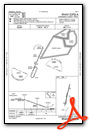
Instrument Approach Procedure (IAP) Charts

Nearby Airports with Instrument Procedures
| ID | Name | Heading / Distance | ||
|---|---|---|---|---|
 |
KBKT | Allan C Perkinson/Blackstone AAF Airport | 058° | 13.1 |
|
W81 | Crewe Municipal Airport | 017° | 13.9 |
|
KAVC | Mecklenburg-Brunswick Regional Airport | 158° | 17.5 |
|
KCXE | Chase City Municipal Airport | 236° | 18.4 |
|
KLVL | Brunswick County Airport | 120° | 21.9 |
|
KFVX | Farmville Regional Airport | 333° | 26.7 |
|
W63 | Lake Country Regional Airport | 219° | 28.3 |
|
KPTB | Tri Cities Exec/Dinwiddie County Airport | 067° | 35.3 |
|
W78 | William M Tuck Airport | 244° | 35.3 |
|
KEMV | Emporia-Greensville Regional Airport | 115° | 37.6 |
|
KHNZ | Henderson/Oxford Airport | 204° | 39.6 |
|
0V4 | Brookneal/Campbell County Airport | 285° | 41.4 |
Airport Images
 looking NW")
By: sbeste


