Login
Register


W81
Crewe Municipal Airport
Official FAA Data Effective 2026-02-19 0901Z
Chart Supplement

VFR Chart of W81
Sectional Charts at SkyVector.com
IFR Chart of W81
Enroute Charts at SkyVector.com
Location Information for W81
Coordinates: N37°10.86' / W78°5.91'Located 01 miles E of Crewe, Virginia on 97 acres of land. View all Airports in Virginia.
Surveyed Elevation is 422 feet MSL.
Operations Data
|
|
Airport Communications
| AWOS-3: | 119.050 |
|---|---|
| CTAF: | 122.800 |
| UNICOM: | 122.800 |
| ASOS at BKT (9.4 SE): | 434-292-1400 |
| ATIS at BKT (9.5 SE): | 119.225 |
| AWOS-3 at W31 (13.9 S): | 123.875 434-676-1078 |
- APCH/DEP SVC PRVDD BY WASHINGTON ARTCC ON FREQS 118.75/377.10 (GREEN BAY RCAG).
Nearby Navigation Aids
|
| ||||||||||||||||||||||||||||||||||||||||||||||||||||||||||||


Runway 15/33
| Dimensions: | 3300 x 60 feet / 1006 x 18 meters | |
|---|---|---|
| Surface: | Asphalt in Poor Condition RWY HAS LRG CRACKS. | |
| Weight Limits: | S-12 | |
| Edge Lighting: | Medium Intensity | |
| Runway 15 | Runway 33 | |
| Coordinates: | N37°11.07' / W78°6.13' | N37°10.65' / W78°5.69' |
| Elevation: | 417.1 | 385.0 |
| Traffic Pattern: | Left | Left |
| Runway Heading: | 140° True | 320° True |
| Displaced Threshold: | 277 Feet | |
| Declared Distances: | TORA:3300 TODA:3300 ASDA:3023 LDA:3023 | |
| Markings: | Non-Precision Instrument in poor condition. | Basic in poor condition. |
| Obstacles: | 57 ft Tree 569 ft from runway, 121 ft left of center APCH RATIO 11:1 TO DTHR. RISING GROUND OFF THE END OF RY 15. |
85 ft Tree 2825 ft from runway, 237 ft right of center |
Services Available
| Fuel: | 100LL (blue) |
|---|---|
| Transient Storage: | Tiedowns |
| Airframe Repair: | NONE |
| Engine Repair: | NONE |
| Bottled Oxygen: | NONE |
| Bulk Oxygen: | NONE |
Ownership Information
| Ownership: | Publicly owned | |
|---|---|---|
| Owner: | TOWN OF CREWE | |
| 125 E CAROLINA AVE | ||
| CREWE, VA 23930 | ||
| 434-645-9453 | ||
| Manager: | PHIL MISKOVIC | |
| 125 E CAROLINA AVE | ||
| CREWE, VA 23930 | ||
| 434-645-1191 | ||
Other Remarks
- FOR CD CTC WASHINGTON ARTCC AT 703-771-3587.
- RWY 15 DSPLD TSHLD MARKINGS IN POOR CONDITION. OLD MARKINGS SHOWING THRU
- MRKGS FADED.
- FOR MIRL RWY 15/33 KEY CTAF 5 TIMES ON; 3 TIMES OFF.
Weather Minimums

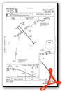
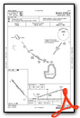
Instrument Approach Procedure (IAP) Charts
Nearby Airports with Instrument Procedures
| ID | Name | Heading / Distance | ||
|---|---|---|---|---|
 |
KBKT | Allan C Perkinson/Blackstone AAF Airport | 132° | 9.5 |
|
W31 | Lunenburg County Airport | 197° | 13.9 |
|
KFVX | Farmville Regional Airport | 303° | 19.4 |
|
KPTB | Tri Cities Exec/Dinwiddie County Airport | 089° | 28.4 |
|
KLVL | Brunswick County Airport | 148° | 28.4 |
|
KAVC | Mecklenburg-Brunswick Regional Airport | 175° | 29.6 |
|
KCXE | Chase City Municipal Airport | 219° | 30.5 |
|
KFCI | Richmond Exec/Chesterfield County Airport | 063° | 30.6 |
|
W63 | Lake Country Regional Airport | 212° | 41.5 |
|
KEMV | Emporia-Greensville Regional Airport | 134° | 41.9 |
|
KRIC | Richmond International Airport | 062° | 42.0 |
|
0V4 | Brookneal/Campbell County Airport | 267° | 44.1 |
Airport Images
Do you have a recent image of this airport? Upload it here!


