Login
Register


C62
Kendallville Municipal Airport
Official FAA Data Effective 2026-02-19 0901Z
Chart Supplement

VFR Chart of C62
Sectional Charts at SkyVector.com
IFR Chart of C62
Enroute Charts at SkyVector.com
Location Information for C62
Coordinates: N41°28.36' / W85°15.65'Located 02 miles N of Kendallville, Indiana on 117 acres of land. View all Airports in Indiana.
Surveyed Elevation is 1004 feet MSL.
Operations Data
|
|
Airport Communications
| AWOS-3P: | 119.925 Tel. 260-347-2967 |
|---|---|
| FORT WAYNE APPROACH: | 127.2 ;SW/NW OF ACTIVE RWY 132.15 ;SE/NE OF ACTIVE RWY 282.325 ;SE/NE OF ACTIVE RWY 284.6 ;SW/NW OF ACTIVE RWY |
| FORT WAYNE DEPARTURE: | 127.2 ;SW/NW OF ACTIVE RWY 132.15 ;SE/NE OF ACTIVE RWY 282.325 ;SE/NE OF ACTIVE RWY 284.6 ;SW/NW OF ACTIVE RWY |
| IC: | 127.2 ;SW/NW OF ACTIVE RWY |
| CTAF: | 122.800 |
| UNICOM: | 122.800 |
| CLASS C: | 282.325 ;SE/NE OF ACTIVE RWY |
| AWOS-3 at ANQ (12.8 NE): | 118.175 260-668-5630 |
| AWOS-3P at GWB (13.7 SE): | 124.15 260-925-8225 |
| AWOS-3 at SMD (20.4 S): | 124.55 260-490-4030 |
- APCH CTL SECTORIZATION BASED UPON FORT WAYNE RWY USAGE.
Nearby Navigation Aids
|
| ||||||||||||||||||||||||||||||||||||||||||||||||||||||||||||


Runway 10/28
160 FT CROPS N OF CNTRLN ENTIRE LEN. | ||
| Dimensions: | 4400 x 75 feet / 1341 x 23 meters | |
|---|---|---|
| Surface: | Asphalt in Good Condition | |
| Weight Limits: | S-12 | |
| Edge Lighting: | Medium Intensity | |
| Runway 10 | Runway 28 | |
| Coordinates: | N41°28.37' / W85°16.13' | N41°28.35' / W85°15.17' |
| Elevation: | 999.7 | 1004.2 |
| Traffic Pattern: | Left | Left |
| Runway Heading: | 92° True | 272° True |
| Markings: | Non-Precision Instrument in good condition. | Non-Precision Instrument in good condition. |
| Glide Slope Indicator | P2L (3.50° Glide Path Angle) | P2L (3.50° Glide Path Angle) UNUSBL BYD 9 DEGS RIGHT OF CNTRLN. |
| REIL: | Yes | Yes |
| Obstacles: | 40 ft Trees 945 ft from runway, 250 ft left of center | 40 ft Trees 990 ft from runway, 140 ft right of center |
Services Available
| Fuel: | 100LL (blue), Jet-A |
|---|---|
| Transient Storage: | Hangars,Tiedowns |
| Airframe Repair: | MINOR |
| Engine Repair: | MINOR |
| Bottled Oxygen: | NOT AVAILABLE |
| Bulk Oxygen: | NOT AVAILABLE |
| Other Services: | CROP DUSTING SERVICES,PILOT INSTRUCTION,AIRCRAFT RENTAL,GLIDER TOWING SERVICES |
Ownership Information
| Ownership: | Publicly owned | |
|---|---|---|
| Owner: | KENDALLVILLE BOAC | |
| 363 E AIRPORT RD | ||
| KENDALLVILLE, IN 46755 | ||
| 260-349-0350 | ||
| Manager: | JOHN KLINE | |
| 363 E. AIRPORT RD. | ||
| KENDALLVILLE, IN 46755 | ||
| 260-349-0350 | ||
Other Remarks
- GLIDER OPS MAY-NOV 0900-SS.
- FOR CD CTC CHICAGO ARTCC AT 630-906-8921.
- 5 FT TRRN DOWN SLOPE 100 FT FM RWY END.
- ACTVT REIL RWY 10 & 28; PAPI RWY 10 & 28; MIRL RWY 10/28 - CTAF.
Weather Minimums

Instrument Approach Procedure (IAP) Charts


Nearby Airports with Instrument Procedures
| ID | Name | Heading / Distance | ||
|---|---|---|---|---|
 |
KANQ | Tri-State Steuben County Airport | 038° | 12.8 |
|
KGWB | Auburn/Dekalb Exec Airport | 137° | 13.4 |
|
KSMD | Smith Field Airport | 166° | 20.3 |
|
KIRS | Kirsch Municipal Airport | 338° | 21.9 |
|
KGSH | Goshen Municipal Airport | 277° | 24.3 |
|
KASW | Warsaw Municipal Airport | 245° | 28.7 |
|
KOEB | Branch County Memorial Airport | 018° | 29.2 |
|
KFWA | Fort Wayne International Airport | 174° | 29.8 |
|
C03 | Nappanee Municipal Airport | 267° | 30.5 |
|
0G6 | Williams County Airport | 090° | 34.0 |
|
KEKM | Elkhart Municipal Airport | 294° | 36.5 |
|
KHHG | Huntington Municipal Airport | 193° | 38.2 |
Airport Images
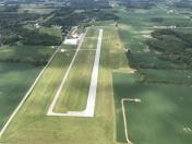
By: btracy62


