Login
Register


C37
Brodhead Airport
Official FAA Data Effective 2026-02-19 0901Z
Chart Supplement

VFR Chart of C37
Sectional Charts at SkyVector.com
IFR Chart of C37
Enroute Charts at SkyVector.com
Location Information for C37
Coordinates: N42°35.73' / W89°22.88'Located 02 miles S of Brodhead, Wisconsin on 86 acres of land. View all Airports in Wisconsin.
Estimated Elevation is 792 feet MSL.
Operations Data
|
|
Airport Communications
| CTAF: | 122.900 |
|---|---|
| AWOS-3 at EFT (9.3 W): | 118.375 608-328-8359 |
| AWOS-3 at JVL (15.1 E): | 608-758-1723 |
| ATIS at JVL (15.1 E): | 128.25 |
Nearby Navigation Aids
|
| ||||||||||||||||||||||||||||||||||||||||||||||||


Runway 09/27
| Dimensions: | 2440 x 155 feet / 744 x 47 meters | |
|---|---|---|
| Surface: | Turf in Fair Condition | |
| Edge Lighting: | Non-Standard RY 9/27 NSTD LIRL. SPACING. | |
| Runway 09 | Runway 27 | |
| Coordinates: | N42°35.80' / W89°23.27' | N42°35.81' / W89°22.73' |
| Elevation: | 792.0 | 785.0 |
| Traffic Pattern: | Left | Left |
| Runway Heading: | 89° True | 269° True |
| Obstacles: | 65 ft Trees 680 ft from runway, 160 ft left of center | 50 ft Trees 670 ft from runway, 120 ft left of center |
Runway 03/21
| Dimensions: | 1500 x 100 feet / 457 x 30 meters | |
|---|---|---|
| Surface: | Turf in Fair Condition | |
| Runway 03 | Runway 21 | |
| Coordinates: | N42°35.55' / W89°22.85' | N42°35.76' / W89°22.67' |
| Elevation: | 792.0 | 788.0 |
| Traffic Pattern: | Left | Left |
| Runway Heading: | 32° True | 212° True |
| Obstacles: | 58 ft Trees 700 ft from runway, 160 ft right of center | |
Runway 15/33
| Dimensions: | 1380 x 100 feet / 421 x 30 meters | |
|---|---|---|
| Surface: | Turf in Fair Condition | |
| Runway 15 | Runway 33 | |
| Coordinates: | N42°35.78' / W89°22.87' | N42°35.58' / W89°22.71' |
| Elevation: | 786.0 | 792.0 |
| Traffic Pattern: | Left | Left |
| Runway Heading: | 148° True | 328° True |
| Obstacles: | 43 ft Trees 615 ft from runway, 170 ft left of center | |
Services Available
| Fuel: | NONE |
|---|---|
| Transient Storage: | Tiedowns |
| Airframe Repair: | MINOR |
| Engine Repair: | MINOR |
| Bottled Oxygen: | NONE |
| Bulk Oxygen: | NONE |
Ownership Information
| Ownership: | Privately Owned | |
|---|---|---|
| Owner: | HAWK AIRE INC. | |
| P O BOX 286 | ||
| BRODHEAD, WI 53520 | ||
| 571-266-2094 | ||
| Manager: | DREW HALLAM | |
| P O BOX 286 | EMAIL ADDRESS: AIRPORTMANAGER@HAWK-AIRE.COM | |
| BRODHEAD, WI 53520 | ||
| 608-879-5425 | ||
Other Remarks
- RYS NOT PLOWED IN WINTER; OPEN TO SKI ACFT.
- CROP DUSTING OPNS IN AREA.
- DEER INVOF MOVEMENT AREAS.
- IRRIGATION EQUIP NR MOVEMENT AREAS.
- FOR CD CTC CHICAGO ARTCC AT 630-906-8921.
- RWY 03/21 MKD WITH RED & WHITE HALF BARRELS.
- RWY 09/27 MKD WITH RED & WHITE HALF BARRELS.
- RY 33 MARKED WITH CONCRETE PAD.
- ACTVT LIRL RY 09/27 - CTAF.
Nearby Airports with Instrument Procedures
| ID | Name | Heading / Distance | ||
|---|---|---|---|---|
 |
KEFT | Monroe Municipal Airport | 277° | 9.3 |
|
KJVL | Southern Wisconsin Regional Airport | 084° | 15.1 |
|
44C | Beloit Airport | 107° | 19.3 |
|
KFEP | Albertus Airport | 203° | 22.8 |
|
KRFD | Chicago/Rockford International Airport | 152° | 27.1 |
|
C77 | Poplar Grove Airport | 123° | 29.2 |
|
87Y | Blackhawk Airfield Airport | 015° | 31.7 |
|
C29 | Middleton Municipal/Morey Field Airport | 348° | 31.8 |
|
KMSN | Dane County Regional/Truax Field Airport | 003° | 32.7 |
|
61C | Fort Atkinson Municipal Airport | 048° | 33.3 |
|
KMRJ | Iowa County Airport | 295° | 41.7 |
|
C02 | Grand Geneva Resort Airport | 088° | 43.9 |
Airport Images
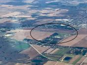
By: james_sm


