Login
Register


CAK
Akron-Canton Regional Airport
Official FAA Data Effective 2026-02-19 0901Z
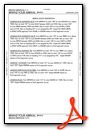
Chart Supplement

KCAK Airport Diagram

VFR Chart of KCAK
Sectional Charts at SkyVector.com
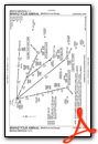
IFR Chart of KCAK
Enroute Charts at SkyVector.com
Location Information for KCAK
Coordinates: N40°54.90' / W81°26.62'Located 10 miles SE of Akron, Ohio on 2300 acres of land. View all Airports in Ohio.
Surveyed Elevation is 1225 feet MSL.
Operations Data
|
|
Airport Communications
| ATIS: | 121.05 |
|---|---|
| ASOS: | Tel. 330-227-8682 |
| AKRON-CANTON TOWER: | 134.75 279.575 |
| AKRON-CANTON GROUND: | 121.7 348.6 |
| CLEVELAND APPROACH: | 118.6 ;187-006 125.5 ;007-186 269.25 ;187-006 371.875 ;007-186 |
| CLEVELAND DEPARTURE: | 118.6 ;187-006 125.5 ;007-186 269.25 ;187-006 371.875 ;007-186 |
| IC: | 125.5 ;007-186 269.25 ;187-006 |
| CLEARANCE DELIVERY: | 132.05 |
| UNICOM: | 122.950 |
| BRWNZ STAR: | 126.55 346.325 |
| ZZIPS STAR: | 125.5 371.875 |
| CLASS C: | 118.6 ;187-006 125.5 ;007-186 269.25 ;187-006 371.875 ;007-186 |
| HUUVR STAR: | 125.5 371.875 |
| ARNG OPS: | 138.55 226.9 40.1FM |
| EMERG: | 121.5 243.0 |
| ASOS at AKR (7.4 N): | 126.825 330-724-4237 |
| AWOS-2 at 1G3 (14.6 N): | 119.15 330-346-1497 |
| AWOS-3 at POV (19.7 NE): | 118.675 330-298-9353 |
- APCH/DEP SVC PRVDD BY CLEVELAND APCH (CLE) 0600-0100. APCH/DEP SVC PRVDD BY CLEVELAND ARTCC (ZOB) ON FREQS 134.9/269.475 (MANSFIELD RCAG) 0100-0600.
Nearby Navigation Aids
|
| ||||||||||||||||||||||||||||||||||||||||||||||||||||||||||||


Runway 05/23
| Dimensions: | 8204 x 150 feet / 2501 x 46 meters | |
|---|---|---|
| Surface: | Asphalt / Grooved in Good Condition | |
| Weight Limits: | S-120, D-160, ST-250
PCR VALUE: 410/F/B/X/U
| |
| Edge Lighting: | High Intensity | |
| Runway 05 | Runway 23 | |
| Coordinates: | N40°54.30' / W81°27.43' | N40°55.22' / W81°26.12' |
| Elevation: | 1179.6 | 1225.5 |
| Traffic Pattern: | Left | Left |
| Runway Heading: | 47° True | 227° True |
| Declared Distances: | TORA:8204 TODA:8204 ASDA:8204 LDA:8204 | TORA:8204 TODA:8204 ASDA:8204 LDA:8204 |
| Markings: | Precision Instrument in good condition. | Precision Instrument in good condition. |
| Glide Slope Indicator | P4L (3.00° Glide Path Angle) | P4L (3.00° Glide Path Angle) |
| RVR Equipment | Touchdown Rollout | Touchdown Rollout |
| Approach Lights: | MALSR 1,400 Foot Medium-intensity Approach Lighting System with runway alignment indicator lights. | MALSR 1,400 Foot Medium-intensity Approach Lighting System with runway alignment indicator lights. |
Runway 01/19
| Dimensions: | 7601 x 150 feet / 2317 x 46 meters | |
|---|---|---|
| Surface: | Asphalt / Grooved in Good Condition | |
| Weight Limits: | S-120, D-160, ST-250
PCR VALUE: 410/F/B/X/U
| |
| Edge Lighting: | High Intensity | |
| Runway 01 | Runway 19 | |
| Coordinates: | N40°54.43' / W81°26.48' | N40°55.68' / W81°26.41' |
| Elevation: | 1208.6 | 1214.0 |
| Traffic Pattern: | Left | Left |
| Runway Heading: | 2° True | 182° True |
| Displaced Threshold: | 601 Feet | |
| Declared Distances: | TORA:7601 TODA:7601 ASDA:7007 LDA:7007 | TORA:7601 TODA:7601 ASDA:7601 LDA:7007 |
| Markings: | Precision Instrument in good condition. | Precision Instrument in good condition. |
| Glide Slope Indicator | P4L (3.00° Glide Path Angle) | |
| RVR Equipment | Touchdown Rollout | Touchdown Rollout |
| Approach Lights: | MALSR 1,400 Foot Medium-intensity Approach Lighting System with runway alignment indicator lights. | MALSR 1,400 Foot Medium-intensity Approach Lighting System with runway alignment indicator lights. |
Services Available
| Fuel: | 100LL (blue), Jet-A |
|---|---|
| Transient Storage: | Hangars,Tiedowns |
| Airframe Repair: | MAJOR |
| Engine Repair: | MAJOR |
| Bottled Oxygen: | NONE |
| Bulk Oxygen: | HIGH/LOW |
| Other Services: | AIR FREIGHT SERVICES,AVIONICS,CARGO HANDLING SERVICES,CHARTER SERVICE,PILOT INSTRUCTION,AIRCRAFT RENTAL,AIRCRAFT SALES |
Ownership Information
| Ownership: | Publicly owned | |
|---|---|---|
| Owner: | AKRON CANTON RGNL ARPT AUTHORITY | |
| 5400 LAUBY RD | ||
| NORTH CANTON, OH 44720 | ||
| 330-499-4059 | ||
| Manager: | RENATO CAMACHO | |
| 5400 LAUBY RD | ||
| NORTH CANTON, OH 44720 | ||
| 330-754-5233 | ||
Other Remarks
- DEER & BIRDS ON & INVOF ARPT.
- ALL ACFT TAXIING ON AIR CAMIS RAMP & NORTH HANGAR AREAS NOT VISIBLE FM ATCT.
- TWY E EAST OF TWY B CLSD TO ACFT OVER 118 FT WINGSPAN.
- FOR CD CTC CLEVELAND ARTCC AT 440-774-0223.
Weather Minimums

Standard Terminal Arrival (STAR) Charts


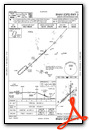
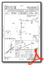
Instrument Approach Procedure (IAP) Charts


Nearby Airports with Instrument Procedures
| ID | Name | Heading / Distance | ||
|---|---|---|---|---|
 |
KAKR | Akron Fulton International Airport | 351° | 7.4 |
|
1G3 | Kent State University Airport | 005° | 14.2 |
|
3G3 | Wadsworth Municipal Airport | 290° | 15.2 |
|
1G5 | Medina Municipal Airport | 311° | 19.5 |
|
KPOV | Portage County Airport | 026° | 19.7 |
|
3G6 | Tri-City Airport | 091° | 20.2 |
|
KBJJ | Wayne County Airport | 263° | 20.4 |
|
38D | Salem Airpark Airport | 085° | 26.5 |
|
KPHD | Harry Clever Field Airport | 177° | 26.7 |
|
KTSO | Carroll County/Tolson Airport | 141° | 27.0 |
|
10G | Holmes County Airport | 226° | 32.6 |
|
4G4 | Youngstown Elser Metro Airport | 085° | 35.0 |
Fuel Providers

Airport Images

By: u235chris


Comments
AD ELEV
In chart supplement AD ELEV is given 1226, while IAC charts says it is 1228.
Fuel Price at CAK
Fuel price at CAK is showing McKinnely Air fuel price. They were sold to AvFlight over a year ago.
We’re excited to share that
We’re excited to share that Castle Aviation has officially opened its new Fixed Base Operator (FBO) facility as of January 6, 2025. Our team is committed to delivering exceptional customer service along with highly competitive fuel pricing. We invite you to stop by and experience all that we have to offer! (Plus we run fuel discounts on weekends and holidays!)