Login
Register


1G5
Medina Municipal Airport
Official FAA Data Effective 2025-12-25 0901Z
Chart Supplement

VFR Chart of 1G5
Sectional Charts at SkyVector.com
IFR Chart of 1G5
Enroute Charts at SkyVector.com
Location Information for 1G5
Coordinates: N41°7.89' / W81°45.89'Located 04 miles E of Medina, Ohio on 283 acres of land. View all Airports in Ohio.
Surveyed Elevation is 1189 feet MSL.
Operations Data
|
|
Airport Communications
| CLEVELAND APPROACH: | 125.35 346.325 |
|---|---|
| CLEVELAND DEPARTURE: | 125.35 346.325 |
| CTAF: | 123.000 |
| UNICOM: | 123.000 |
| ASOS at AKR (14.8 SE): | 126.825 330-724-4237 |
| AWOS-2 at 1G3 (15.8 E): | 119.15 330-346-1497 |
| ASOS at BJJ (16.5 S): | 118.075 330-669-9105 |
Nearby Navigation Aids
|
| ||||||||||||||||||||||||||||||||||||||||||||||||||||||||||||


Runway 09/27
| Dimensions: | 3556 x 75 feet / 1084 x 23 meters | |
|---|---|---|
| Surface: | Asphalt in Good Condition | |
| Weight Limits: | S-30 | |
| Edge Lighting: | Medium Intensity | |
| Runway 09 | Runway 27 | |
| Coordinates: | N41°7.88' / W81°46.43' | N41°7.95' / W81°45.66' |
| Elevation: | 1168.8 | 1182.8 |
| Traffic Pattern: | Left | Left |
| Runway Heading: | 84° True | 264° True |
| Markings: | Non-Precision Instrument in good condition. | Non-Precision Instrument in good condition. |
| Glide Slope Indicator | P4L (3.00° Glide Path Angle) U/S INDEFLY. | P4L (3.50° Glide Path Angle) |
| REIL: | Yes | |
| Obstacles: | 50 ft Tree 515 ft from runway, 230 ft right of center +4-6 FT BRUSH, 100-200 FT DIST, 180-200 FT R. |
+0-10 FT BRUSH 175-200 FT FM 100 FT R. |
Runway 01/19
| Dimensions: | 2868 x 60 feet / 874 x 18 meters | |
|---|---|---|
| Surface: | Asphalt in Fair Condition | |
| Weight Limits: | S-25 | |
| Edge Lighting: | Medium Intensity | |
| Runway 01 | Runway 19 | |
| Coordinates: | N41°7.62' / W81°45.72' | N41°8.09' / W81°45.71' |
| Elevation: | 1170.1 | 1189.8 |
| Traffic Pattern: | Left | Left |
| Runway Heading: | 1° True | 181° True |
| Displaced Threshold: | 737 Feet | |
| Markings: | Basic in good condition. | Basic in good condition. |
| Glide Slope Indicator | P4L (3.00° Glide Path Angle) | P4L (4.00° Glide Path Angle) |
| Obstacles: | 15 ft Power Line 450 ft from runway ADNL OBST: +15 FT ROAD 380 FT FM 140 FT L&R 12:1 OBST CLNS SLOPE NOT MKD OR LGTD. |
80 ft Trees 625 ft from runway, 170 ft left of center |
Services Available
| Fuel: | 100LL (blue), Jet A+ |
|---|---|
| Transient Storage: | Hangars,Tiedowns TNST HANGAR: PPR. |
| Airframe Repair: | MAJOR |
| Engine Repair: | MAJOR |
| Bottled Oxygen: | NOT AVAILABLE |
| Bulk Oxygen: | NOT AVAILABLE |
| Other Services: | PILOT INSTRUCTION,AIRCRAFT RENTAL,ANNUAL SURVEYING |
Ownership Information
| Ownership: | Publicly owned | |
|---|---|---|
| Owner: | CITY OF MEDINA | |
| PO BOX 703 | ||
| MEDINA, OH 44258-0703 | ||
| 330-725-8861 | ||
| Manager: | GREG HUBER | |
| PO BOX 703 | ||
| MEDINA, OH 44258-0703 | ||
| 330-239-1606 | ||
Other Remarks
- DEER, BIRDS, & OTR WILDLIFE ON & INVOF ARPT.
- FOR CD CTC CLEVELAND APCH AT 216-352-2323.
- NOISE SENSITIVE RESIDENTIAL AND LIVESTOCK AREAS INVOF ALL RWY ENDS. MNTN RWY HDG TIL RCHNG TPA.
- 0LL AVBL H24 SELF SER.
- ACTVT REIL RWY 27; PAPI RWY 01, 19, & 27; MIRL RWY 01/19 & 09/27 - CTAF. PAPI RWY 01, 19, & 27 OPR CONSLY DUSK-2200.
Weather Minimums
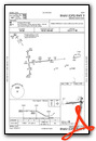
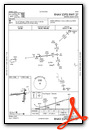
Instrument Approach Procedure (IAP) Charts

Nearby Airports with Instrument Procedures
| ID | Name | Heading / Distance | ||
|---|---|---|---|---|
 |
3G3 | Wadsworth Municipal Airport | 177° | 7.7 |
|
KAKR | Akron Fulton International Airport | 112° | 14.6 |
|
1G3 | Kent State University Airport | 085° | 15.9 |
|
KBJJ | Wayne County Airport | 200° | 16.4 |
|
KCLE | Cleveland-Hopkins International Airport | 346° | 17.2 |
|
1G1 | Elyria Airport | 308° | 19.4 |
|
KCAK | Akron-Canton Regional Airport | 131° | 19.5 |
|
KLPR | Lorain County Regional Airport | 304° | 22.6 |
|
KBKL | Burke Lakefront Airport | 009° | 23.5 |
|
KPOV | Portage County Airport | 078° | 23.7 |
|
3G4 | Ashland County Airport | 238° | 26.2 |
|
KCGF | Cuyahoga County Airport | 025° | 28.8 |
Airport Images
Do you have a recent image of this airport? Upload it here!


