Login
Register


CEZ
Cortez Municipal Airport
Official FAA Data Effective 2025-11-27 0901Z
Chart Supplement

KCEZ Airport Diagram

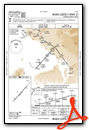
VFR Chart of KCEZ
Sectional Charts at SkyVector.com
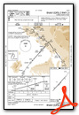
IFR Chart of KCEZ
Enroute Charts at SkyVector.com
Location Information for KCEZ
Coordinates: N37°18.18' / W108°37.68'Located 03 miles SW of Cortez, Colorado on 622 acres of land. View all Airports in Colorado.
Surveyed Elevation is 5917 feet MSL.
Operations Data
|
|
Airport Communications
| ASOS: | 135.625 Tel. 970-564-0193 |
|---|---|
| UNICOM: | 122.800 |
| CTAF: | 122.800 |
| ASOS at FMN (38.6 SE): | 127.15 505-421-0068 |
| ATIS at FMN (38.8 SE): | 127.15 |
| ASOS at DRO (42.8 E): | 120.625 970-259-3579 |
- APCH/DEP CTL SVC PRVDD BY DEN ARTCC (ZDV) ON FREQS 118.575/348.7 (CORTEZ RCAG).
Nearby Navigation Aids
|
| ||||||||||||||||||||||||||||||||||||


Runway 03/21
| Dimensions: | 7205 x 100 feet / 2196 x 30 meters | |
|---|---|---|
| Surface: | Asphalt / Porous Friction Course in Good Condition | |
| Weight Limits: | S-40, D-56 | |
| Edge Lighting: | Medium Intensity | |
| Runway 03 | Runway 21 | |
| Coordinates: | N37°17.74' / W108°38.18' | N37°18.62' / W108°37.19' |
| Elevation: | 5913.2 | 5909.2 |
| Traffic Pattern: | Left | Left |
| Runway Heading: | 42° True | 222° True |
| Declared Distances: | TORA:7205 TODA:7205 ASDA:7205 LDA:7205 | TORA:7205 TODA:7205 ASDA:7205 LDA:7205 |
| Markings: | Non-Precision Instrument in good condition. | Non-Precision Instrument in good condition. |
| Glide Slope Indicator | P4L (3.00° Glide Path Angle) | V4L (3.00° Glide Path Angle) |
| REIL: | Yes | Yes |
| Obstacles: | 59 ft Trees 2000 ft from runway, 350 ft right of center 133 FT POLE ON CNTRLN. |
16 ft Road 680 ft from runway, 300 ft right of center |
Services Available
| Fuel: | 100LL (blue), Jet-A |
|---|---|
| Transient Storage: | Hangars,Tiedowns |
| Airframe Repair: | MAJOR |
| Engine Repair: | MAJOR |
| Bottled Oxygen: | NOT AVAILABLE |
| Bulk Oxygen: | HIGH |
| Other Services: | CHARTER SERVICE,PILOT INSTRUCTION,AIRCRAFT RENTAL,AIRCRAFT SALES |
Ownership Information
| Ownership: | Publicly owned | |
|---|---|---|
| Owner: | CITY OF CORTEZ | |
| 123 ROGER SMITH AVE. | ||
| CORTEZ, CO 81321 | ||
| (970) 565-7458 | ||
| Manager: | JEREMY PATTON | |
| 123 ROGER SMITH AVE. | ||
| CORTEZ, CO 81321 | ||
| 970-565-7458 | ||
Other Remarks
- ACFT GTR THAN 20000 LBS DUAL WHEEL RSTRD TO TWY CONNECTOR A2; BACK TAXI ON RWY TO & FM TWY CONNECTOR A2 TO APRON.
- FOR CD CTC DENVER ARTCC ON FREQ. IF UNA, CTC FSS ON FREQ VIA RCO. IF UNA, CTC DENVER ARTCC AT 303-651-4257.
- PPR FOR UNSKED ACR OPS WITH MORE THAN 30 PAX SEATS - AMGR.
- ACTVT REIL RWY 03 & 21; MIRL RWY 03/21 - CTAF. PAPI RWY 03 & VASI RWY 21 ON CONSLY.
Weather Minimums


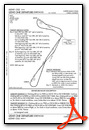
Instrument Approach Procedure (IAP) Charts


Departure Procedure (DP) Charts
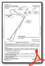
Departure Procedure Obstacles (DPO) Charts
Nearby Airports with Instrument Procedures
| ID | Name | Heading / Distance | ||
|---|---|---|---|---|
 |
KFMN | Four Corners Regional Airport | 150° | 38.7 |
|
KDRO | Durango-La Plata County Airport | 101° | 42.9 |
|
KBDG | Blanding Municipal Airport | 292° | 44.2 |
|
U64 | Monticello Airport | 318° | 50.8 |
|
KTEX | Telluride Regional Airport | 041° | 51.9 |
|
KAIB | Hopkins Field Airport | 003° | 56.2 |
|
KPSO | Stevens Field Airport | 090° | 75.3 |
|
KMTJ | Montrose Regional Airport | 025° | 80.3 |
|
KAJZ | Blake Field Airport | 016° | 92.8 |
|
KRQE | Window Rock Airport | 192° | 101.2 |
|
KCNY | Canyonlands Regional Airport | 328° | 102.2 |
|
KGUP | Gallup Municipal Airport | 184° | 107.7 |
Airport Images
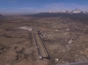
By: animas


