Login
Register
PSO
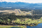
Stevens Field Airport
Official FAA Data Effective 2025-12-25 0901Z
VFR Chart of KPSO
Sectional Charts at SkyVector.com
IFR Chart of KPSO
Enroute Charts at SkyVector.com
Location Information for KPSO
Coordinates: N37°17.17' / W107°3.36'Located 03 miles NW of Pagosa Springs, Colorado on 328 acres of land. View all Airports in Colorado.
Surveyed Elevation is 7663 feet MSL.
TPA 1000 FT AGL FOR PROP ACFT AND 1500 FT AGL FOR JET ACFT.
Operations Data
|
|
Airport Communications
| AWOS-3PT: | 127.175 Tel. 970-731-0365 |
|---|---|
| UNICOM: | 122.700 |
| CTAF: | 122.700 |
| AWOS-3 at CPW (16.1 NE): | 121.125 970-264-2180 |
| AWOS-3 at C24 (32.8 N): | 120.00 719-658-1011 |
| ASOS at DRO (34.3 W): | 120.625 970-259-3579 |
- APCH/DEP CTL SVC PRVDD BY DENVER ARTCC (ZDV) ON FREQS 118.575/348.7 (DURANGO RCAG).
Nearby Navigation Aids
|
| ||||||||||||||||||||||||||||||||||||
Runway 01/19
| Dimensions: | 8100 x 100 feet / 2469 x 30 meters | |
|---|---|---|
| Surface: | Asphalt in Fair Condition | |
| Weight Limits: | 24 /F/B/X/U, S-59, D-70 | |
| Edge Lighting: | Medium Intensity | |
| Runway 01 | Runway 19 | |
| Coordinates: | N37°16.56' / W107°3.70' | N37°17.79' / W107°3.02' |
| Elevation: | 7628.5 | 7663.2 |
| Runway Heading: | 23° True | 203° True |
| Markings: | Non-Precision Instrument in fair condition. | Non-Precision Instrument in fair condition. |
| Glide Slope Indicator | P4L (3.00° Glide Path Angle) | P4R (3.50° Glide Path Angle) |
| REIL: | Yes | Yes |
| Obstacles: | 53 ft Trees 1685 ft from runway, 140 ft left of center | |
Services Available
| Fuel: | 100LL (blue), Jet-A |
|---|---|
| Transient Storage: | Hangars,Tiedowns |
| Airframe Repair: | MINOR |
| Engine Repair: | MINOR |
| Bottled Oxygen: | NONE |
| Bulk Oxygen: | HIGH |
| Other Services: | PILOT INSTRUCTION |
Ownership Information
| Ownership: | Publicly owned | |
|---|---|---|
| Owner: | ARCHULETA CO ARPT AUTHORITY | |
| BOX 4666 | ||
| PAGOSA SPRINGS, CO 81157 | ||
| 970-731-3060 | ||
| Manager: | CHRIS TORRES | |
| PO BOX 4666 | ||
| PAGOSA SPRINGS, CO 81147 | ||
| 970-731-3060 | ||
Other Remarks
- WILDLIFE ON & INVOF ARPT.
- TWY B CLSD TO ACFT 12500 LBS & OVER.
- BALLOON OPS INVOF AIRPORT.
- FOR CD CTC DENVER ARTCC AT 303-651-4257.
- ACTVT REIL RWY 01 & 19; PAPI RWY 01 & 19; MIRL RWY 01/19. - CTAF.
- TPA 1000 FT AGL FOR PROP ACFT AND 1500 FT AGL FOR JET ACFT.
Weather Minimums
Instrument Approach Procedure (IAP) Charts
Nearby Airports with Instrument Procedures
| ID | Name | Heading / Distance | ||
|---|---|---|---|---|
 |
KDRO | Durango-La Plata County Airport | 256° | 34.4 |
 |
KRCV | Astronaut Kent Rominger Airport | 052° | 42.3 |
 |
KMVI | Monte Vista Municipal Airport | 072° | 50.4 |
 |
KTEX | Telluride Regional Airport | 314° | 57.0 |
 |
KALS | San Luis Valley Regional/Bergman Field Airport | 080° | 57.5 |
 |
KFMN | Four Corners Regional Airport | 240° | 65.2 |
 |
KCEZ | Cortez Municipal Airport | 271° | 75.3 |
 |
KGUC | Gunnison-Crested Butte Regional Airport | 004° | 75.0 |
 |
KSKX | Taos Regional Airport | 126° | 83.3 |
 |
KMTJ | Montrose Regional Airport | 331° | 83.4 |
 |
KANK | Salida/Harriett Alexander Field Airport | 032° | 89.0 |
 |
KAIB | Hopkins Field Airport | 308° | 91.6 |


Comments
Good runway and ramp. Self
Good runway and ramp. Self serve 100LL is available on the ramp to the right of the terminal as you face it from the runway. Excellent terminal and FBO. Courtesy car available. Lots of good restaraunts and nice hotels in Pagosa Springs. Say hi to the hanger cat.
Good runway and ramp. Self
The runway and ramp at this facility are in excellent condition, providing a smooth and efficient experience for both takeoffs and landings. Self-service options are well-maintained and easy to use, contributing to a hassle-free process. The overall organization and cleanliness of the area are commendable. Highly recommend for any pilot or aviation enthusiast seeking a reliable and well-kept airstrip. Keep up the great work!
Pages