Login
Register


CNW
Tstc Waco Airport
Official FAA Data Effective 2026-01-22 0901Z
Chart Supplement

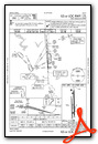
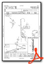
KCNW Airport Diagram

VFR Chart of KCNW
Sectional Charts at SkyVector.com
IFR Chart of KCNW
Enroute Charts at SkyVector.com
Location Information for KCNW
Coordinates: N31°38.27' / W97°4.45'Located 08 miles NE of Waco, Texas on 2200 acres of land. View all Airports in Texas.
Surveyed Elevation is 470 feet MSL.
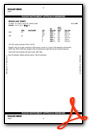
Operations Data
|
|
Airport Communications
| AWOS-3PT: | 134.225 Tel. 254-867-3880 |
|---|---|
| TSTC TOWER: | 124.0 255.7 |
| TSTC GROUND: | 121.7 |
| WACO APPROACH: | 127.65 227.125 |
| WACO DEPARTURE: | 126.125 227.125 |
| ASR: | 132.525 |
| UNICOM: | 122.950 |
| CTAF: | 124.000 |
| ATIS at ACT (8.1 W): | 123.85 |
| ASOS at ACT (8.2 W): | 254-218-3267 |
| AWOS-3PT at PWG (15.4 SW): | 135.525 254-848-4581 |
- APCH/DEP CTL SVC PRVDD BY FORT WORTH ARTCC (ZFW) ON FREQS 133.3/269.5 (WACO RCAG) WHEN WACO APCH CTL (ACT) CLSD.
Nearby Navigation Aids
|
| ||||||||||||||||||||||||||||||||||||||||||||||||||||||||||||


Runway 17L/35R
| Dimensions: | 8600 x 150 feet / 2621 x 46 meters | |
|---|---|---|
| Surface: | Asphalt in Excellent Condition | |
| Weight Limits: | S-50, D-200, ST-450 | |
| Edge Lighting: | Medium Intensity | |
| Runway 17L | Runway 35R | |
| Coordinates: | N31°39.10' / W97°4.43' | N31°37.68' / W97°4.36' |
| Elevation: | 469.8 | 456.0 |
| Traffic Pattern: | Left | Right |
| Runway Heading: | 178° True | 358° True |
| Markings: | Precision Instrument in good condition. | Precision Instrument in good condition. |
| Glide Slope Indicator | P4R (3.00° Glide Path Angle) | P4L (3.00° Glide Path Angle) |
| Approach Lights: | MALSR 1,400 Foot Medium-intensity Approach Lighting System with runway alignment indicator lights. | |
| Obstacles: | 44 ft Trees 1929 ft from runway, 790 ft right of center | 67 ft Trees 2515 ft from runway, 750 ft right of center |
Runway 17R/35L
| Dimensions: | 6291 x 75 feet / 1917 x 23 meters | |
|---|---|---|
| Surface: | Concrete in Good Condition | |
| Weight Limits: | S-25, D-76, ST-140 | |
| Runway 17R | Runway 35L | |
| Coordinates: | N31°38.63' / W97°4.55' | N31°37.59' / W97°4.50' |
| Elevation: | 466.6 | 459.6 |
| Traffic Pattern: | Right | Left |
| Runway Heading: | 178° True | 358° True |
| Markings: | Non-Precision Instrument in fair condition. | Non-Precision Instrument in fair condition. |
| Obstacles: | 48 ft Trees 1560 ft from runway, 410 ft right of center | |
Services Available
| Fuel: | 100LL (blue), Jet-A |
|---|---|
| Transient Storage: | Tiedowns |
| Airframe Repair: | MINOR |
| Engine Repair: | MINOR |
| Bottled Oxygen: | NOT AVAILABLE |
| Bulk Oxygen: | NOT AVAILABLE |
| Other Services: | AIR AMBULANCE SERVICES,PILOT INSTRUCTION |
Ownership Information
| Ownership: | Publicly owned | |
|---|---|---|
| Owner: | TEXAS STATE TECH COLLEGE | |
| 3801 CAMPUS DRIVE | ||
| WACO, TX 76705 | ||
| 254-799-3611 | ||
| Manager: | GORDON ROWELL | |
| 3801 CAMPUS DRIVE | ||
| WACO, TX 76705 | ||
| 254-867-2280 | ||
Other Remarks
- EXTSV FLT TRNG IN CLASS D AIRSPACE SFC TO 3000 FT AGL.
- APU AVBL FOR JET ACFT.
- RWY 17R-35L NOT LGTD. MAY BE USED FOR TAXI AND HEL OPNS.
- AMGR CELL 910-578-8509.
- WHEN ATCT CLSD MIRL RWY 17L/35R PRESET LOW INTST; TO INCR INTST & ACTVT MALSR RWY 17L & PAPI RWY 17L & 35R - 121.7.
Weather Minimums

Instrument Approach Procedure (IAP) Charts

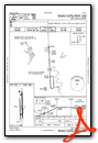
Nearby Airports with Instrument Procedures
| ID | Name | Heading / Distance | ||
|---|---|---|---|---|
 |
KACT | Waco Regional Airport | 259° | 8.1 |
|
KPWG | Mc Gregor Exec Airport | 233° | 15.4 |
|
T15 | Marlin Airport | 147° | 21.1 |
|
KINJ | Hillsboro Municipal Airport | 357° | 26.7 |
|
KLXY | Mexia-Limestone County Airport | 089° | 28.7 |
|
KTPL | Draughon-Miller Central Texas Regional Airport | 210° | 33.8 |
|
KCRS | C David Campbell Field-Corsicana Municipal Airport | 055° | 41.6 |
|
KILE | Skylark Field Airport | 223° | 45.6 |
|
F41 | Ennis Municipal Airport | 026° | 46.4 |
|
KCPT | Cleburne Regional Airport | 336° | 46.6 |
|
KJWY | Mid-Way Regional Airport | 009° | 49.8 |
|
KLHB | Hearne Municipal Airport | 152° | 51.4 |
Airport Images

By: jahangiriali


