Login
Register


ACT
Waco Regional Airport
Official FAA Data Effective 2026-01-22 0901Z
Chart Supplement

KACT Airport Diagram

VFR Chart of KACT
Sectional Charts at SkyVector.com
IFR Chart of KACT
Enroute Charts at SkyVector.com
Location Information for KACT
Coordinates: N31°36.73' / W97°13.82'Located 05 miles NW of Waco, Texas on 1369 acres of land. View all Airports in Texas.
Surveyed Elevation is 516 feet MSL.
Operations Data
|
|
Airport Communications
| ATIS: | 123.85 |
|---|---|
| ASOS: | Tel. 254-218-3267 |
| WACO TOWER: | 119.3 257.8 |
| WACO GROUND: | 121.9 |
| WACO APPROACH: | 127.65 227.125 |
| WACO DEPARTURE: | 126.125 227.125 |
| ASR: | 132.525 |
| EMERG: | 121.5 243.0 |
| CTAF: | 119.300 |
| UNICOM: | 122.950 |
| AWOS-3PT at CNW (8.1 E): | 134.225 254-867-3880 |
| AWOS-3PT at PWG (8.7 SW): | 135.525 254-848-4581 |
| AWOS-3PT at TPL (29.1 S): | 134.975 254-774-8337 |
- APCH/DEP CTL SVC PRVDD BY FORT WORTH ARTCC (ZFW) ON FREQS 133.3/269.5 (WACO RCAG) WHEN WACO APCH CTL (ACT) CLSD.
Nearby Navigation Aids
|
| ||||||||||||||||||||||||||||||||||||||||||||||||||||||||||||


Runway 01/19
| Dimensions: | 7107 x 150 feet / 2166 x 46 meters | |
|---|---|---|
| Surface: | Asphalt / Grooved in Good Condition | |
| Weight Limits: | S-50, D-82, DT-166
PCR VALUE: 547/F/B/W/T
| |
| Edge Lighting: | High Intensity | |
| Runway 01 | Runway 19 | |
| Coordinates: | N31°36.21' / W97°13.80' | N31°37.35' / W97°13.46' |
| Elevation: | 508.4 | 502.3 |
| Traffic Pattern: | Left | Left |
| Runway Heading: | 14° True | 194° True |
| Displaced Threshold: | 102 Feet | |
| Declared Distances: | TORA:7107 TODA:7107 ASDA:7107 LDA:7005 | TORA:7107 TODA:7107 ASDA:6605 LDA:6605 |
| Markings: | Non-Precision Instrument in good condition. | Precision Instrument in good condition. |
| Glide Slope Indicator | P4R (3.00° Glide Path Angle) | |
| RVR Equipment | Rollout | Touchdown |
| Approach Lights: | MALSR 1,400 Foot Medium-intensity Approach Lighting System with runway alignment indicator lights. | |
| Obstacles: | 10 ft Road 650 ft from runway | |
Runway 14/32
| Dimensions: | 5103 x 150 feet / 1555 x 46 meters | |
|---|---|---|
| Surface: | Asphalt / Grooved in Good Condition | |
| Weight Limits: | S-50, D-82
PCR VALUE: 462/F/B/W/T
| |
| Edge Lighting: | Medium Intensity | |
| Runway 14 | Runway 32 | |
| Coordinates: | N31°37.03' / W97°14.33' | N31°36.30' / W97°13.83' |
| Elevation: | 508.6 | 511.7 |
| Traffic Pattern: | Left | Left |
| Runway Heading: | 149° True | 329° True |
| Declared Distances: | TORA:5103 TODA:5103 ASDA:5103 LDA:5103 | TORA:5103 TODA:5103 ASDA:5103 LDA:5103 |
| Markings: | Non-Precision Instrument in fair condition. | Non-Precision Instrument in fair condition. |
| Glide Slope Indicator | P4L (3.00° Glide Path Angle) | P4L (3.00° Glide Path Angle) |
| REIL: | Yes | |
| Obstacles: | 10 ft Road 550 ft from runway | |
Services Available
| Fuel: | 100LL (blue), Jet-A, UL94 |
|---|---|
| Transient Storage: | Hangars,Tiedowns |
| Airframe Repair: | MAJOR |
| Engine Repair: | MAJOR |
| Bottled Oxygen: | NONE |
| Bulk Oxygen: | HIGH |
| Other Services: | CHARTER SERVICE |
Ownership Information
| Ownership: | Publicly owned | |
|---|---|---|
| Owner: | CITY OF WACO | |
| PO BOX 2570 | ||
| WACO, TX 76702-2570 | ||
| 254-750-5640 | ||
| Manager: | JAMES HARRIS | |
| 7909 KARL MAY DRIVE | ||
| WACO, TX 76708 | ||
| 254-750-8657 | ||
Other Remarks
- FOR CD CTC WACO APCH AT 121.9 OR CTC FORT WORTH ARTCC AT 817-858-7584.
- WHEN ATCT CLSD: MALSR RWY 19; HIRL RWY 01/19 PRESET LOW INTST, TO INCR INTST ACTVT - CTAF. REIL RWY 14; MIRL RWY 14/32; TWY LGTS PRESET LOW INTST WHEN WIND FAVORS, OTRW NOT AVBL.
Weather Minimums

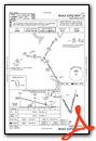
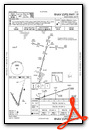
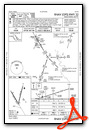
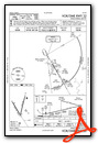
Instrument Approach Procedure (IAP) Charts

Nearby Airports with Instrument Procedures
| ID | Name | Heading / Distance | ||
|---|---|---|---|---|
 |
KCNW | Tstc Waco Airport | 079° | 8.1 |
|
KPWG | Mc Gregor Exec Airport | 210° | 8.8 |
|
T15 | Marlin Airport | 129° | 25.3 |
|
KTPL | Draughon-Miller Central Texas Regional Airport | 198° | 29.0 |
|
KINJ | Hillsboro Municipal Airport | 013° | 29.0 |
|
KLXY | Mexia-Limestone County Airport | 087° | 36.7 |
|
KILE | Skylark Field Airport | 216° | 39.3 |
|
KGRK | Robert Gray AAF Airport | 223° | 44.8 |
|
KCPT | Cleburne Regional Airport | 346° | 45.6 |
|
KMNZ | Hamilton Municipal Airport | 274° | 47.1 |
|
KCRS | C David Campbell Field-Corsicana Municipal Airport | 059° | 49.2 |
|
F41 | Ennis Municipal Airport | 033° | 51.8 |
Fuel Providers

Airport Images
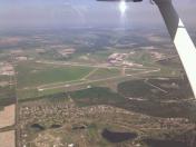
By: hsukkar


