Login
Register


CPC
Columbus County Regional Airport
Official FAA Data Effective 2026-02-19 0901Z
Chart Supplement

VFR Chart of KCPC
Sectional Charts at SkyVector.com
IFR Chart of KCPC
Enroute Charts at SkyVector.com
Location Information for KCPC
Coordinates: N34°16.37' / W78°42.90'Located 03 miles S of Whiteville, North Carolina on 300 acres of land. View all Airports in North Carolina.
Surveyed Elevation is 99 feet MSL.
Operations Data
|
|
Airport Communications
| AWOS-3: | 118.375 Tel. 910-642-7508 |
|---|---|
| MYRTLE BEACH APPROACH: | 119.2 350.3 |
| MYRTLE BEACH DEPARTURE: | 119.2 350.3 |
| UNICOM: | 122.800 |
| CTAF: | 122.800 |
| AWOS-3P at EYF (21.1 N): | 119.475 910-862-9982 |
| ASOS at LBT (26.4 NW): | 134.775 910-739-7120 |
| ASOS at CRE (27.4 S): | 119.625 843-361-2802 |
- APCH/DEP SVC PRVDD BY JACKSONVILLE ARTCC ON FREQS 134.375/317.550 (MYRTLE BEACH RCAG) WHEN MYRTLE BEACH APCH CTL CLSD.
Nearby Navigation Aids
|
| ||||||||||||||||||||||||||||||||||||||||||||||||||||||||||||


Runway 06/24
| Dimensions: | 5500 x 75 feet / 1676 x 23 meters | |
|---|---|---|
| Surface: | Asphalt in Good Condition | |
| Weight Limits: | S-45, D-60 | |
| Edge Lighting: | Medium Intensity | |
| Runway 06 | Runway 24 | |
| Coordinates: | N34°16.07' / W78°43.30' | N34°16.68' / W78°42.50' |
| Elevation: | 99.4 | 69.2 |
| Traffic Pattern: | Left | Left |
| Runway Heading: | 48° True | 228° True |
| Markings: | Non-Precision Instrument in fair condition. | Non-Precision Instrument in fair condition. |
| Glide Slope Indicator | P2L (3.00° Glide Path Angle) | P2L (3.25° Glide Path Angle) |
| REIL: | Yes | Yes |
| Obstacles: | 77 ft Trees 2007 ft from runway, 405 ft left of center | 66 ft Trees 2195 ft from runway, 138 ft left of center |
Services Available
| Fuel: | 100LL (blue), Jet A-1+ |
|---|---|
| Transient Storage: | Tiedowns |
| Airframe Repair: | NONE |
| Engine Repair: | NONE |
| Bottled Oxygen: | NONE |
| Bulk Oxygen: | NONE |
Ownership Information
| Ownership: | Publicly owned | |
|---|---|---|
| Owner: | COLUMBUS COUNTY | |
| 111 WASHINGTON ST | ||
| WHITEVILLE, NC 28472 | ||
| 910-640-6601 | ||
| Manager: | PHIL EDWARDS | |
| 467 AIRPORT ROAD | ||
| WHITEVILLE, NC 28472 | ||
| 910-642-6187 | ||
Other Remarks
- DEER AND TURKEYS ON INVOF ARPT.
- ARPT UNATNDD EASTER SUNDAY, 4TH JULY, THANKSGIVING DAY, CHRISTMAS EVE AND CHRISTMAS DAY.
- NO OFF-PAVEMENT LDG ALLOWED.
- FOR CD CTC MYRTLE BEACH APCH AT 843-477-2727 OR 843-477-2704, WHEN APCH CLSD CTC JACKSONVILLE ARTCC AT 904-845-1592.
- 0LL FUEL 24 HR CREDIT CARD SVC AVBL.
- ACTVT REIL RWY 06 & 24; MIRL RWY 06/24 - CTAF. PAPI RWY 06 & 24 ON CONSLY.
Weather Minimums

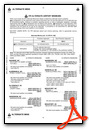
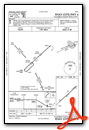
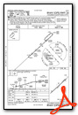
Instrument Approach Procedure (IAP) Charts
Nearby Airports with Instrument Procedures
| ID | Name | Heading / Distance | ||
|---|---|---|---|---|
 |
5J9 | Twin City Airport | 214° | 13.3 |
|
KEYF | Curtis L Brown Jr Field Airport | 018° | 20.8 |
|
KLBT | Lumberton Regional Airport | 319° | 26.5 |
|
KCRE | Grand Strand Airport | 180° | 27.6 |
|
KMAO | Marion County Airport | 260° | 31.3 |
|
KHYW | Conway-Horry County Airport | 217° | 33.5 |
|
KDLC | Dillon County Airport | 288° | 34.1 |
|
KMYR | Myrtle Beach International Airport | 196° | 37.1 |
|
KSUT | Cape Fear Regional Jetport/Howie Franklin Field Airport | 122° | 38.0 |
|
KILM | Wilmington International Airport | 089° | 40.4 |
|
KFAY | Fayetteville Regional/Grannis Field Airport | 349° | 43.8 |
|
KACZ | Wallace-Pender Airport | 052° | 44.2 |
Airport Images
Do you have a recent image of this airport? Upload it here!


