Login
Register


CSQ
Creston Municipal Airport
Official FAA Data Effective 2026-01-22 0901Z
Chart Supplement

VFR Chart of KCSQ
Sectional Charts at SkyVector.com
IFR Chart of KCSQ
Enroute Charts at SkyVector.com
Location Information for KCSQ
Coordinates: N41°1.29' / W94°21.80'Located 03 miles S of Creston, Iowa on 360 acres of land. View all Airports in Iowa.
Surveyed Elevation is 1299 feet MSL.
Operations Data
|
|
Airport Communications
| AWOS-3: | 124.75 Tel. 641-782-6286 |
|---|---|
| CTAF: | 122.800 |
| UNICOM: | 122.800 |
| AWOS-3 at I75 (30.6 E): | 120.975 641-342-1422 |
| ASOS at LWD (31.3 SE): | 120.0 319-462-8806 |
| AWOS-3 at ICL (34.8 SW): | 132.025 712-542-3345 |
- APCH/DEP SVC PRVDD BY MINNEAPOLIS ARTCC ON FREQS 125.65/306.950 (DES MOINES RCAG).
Nearby Navigation Aids
|
| ||||||||||||||||||||||||||||||||||||||||||


Runway 16/34
| Dimensions: | 4901 x 75 feet / 1494 x 23 meters | |
|---|---|---|
| Surface: | Concrete in Excellent Condition | |
| Weight Limits: | 13 /F/D/X/T, S-15 | |
| Edge Lighting: | Medium Intensity | |
| Runway 16 | Runway 34 | |
| Coordinates: | N41°1.66' / W94°21.97' | N41°0.88' / W94°21.69' |
| Elevation: | 1288.6 | 1294.9 |
| Traffic Pattern: | Left | Left |
| Runway Heading: | 165° True | 345° True |
| Markings: | Non-Precision Instrument in good condition. | Non-Precision Instrument in good condition. |
| Glide Slope Indicator | P2L (3.00° Glide Path Angle) | P2L (3.00° Glide Path Angle) |
| REIL: | Yes | Yes |
| Obstacles: | 13 ft Fence 520 ft from runway | 5 ft Tree 326 ft from runway, 135 ft right of center |
Runway 04/22
CLSD DURG WINTER. | ||
| Dimensions: | 1692 x 100 feet / 516 x 30 meters | |
|---|---|---|
| Surface: | Turf in Good Condition | |
| Runway 04 | Runway 22 | |
| Coordinates: | N41°1.24' / W94°21.84' | N41°1.44' / W94°21.58' |
| Elevation: | 1299.7 | |
| Runway Heading: | 45° True | 225° True |
Services Available
| Fuel: | 100LL (blue), Jet-A |
|---|---|
| Transient Storage: | Hangars,Tiedowns |
| Airframe Repair: | MINOR |
| Engine Repair: | MINOR |
| Bottled Oxygen: | NOT AVAILABLE |
| Bulk Oxygen: | NOT AVAILABLE |
Ownership Information
| Ownership: | Publicly owned | |
|---|---|---|
| Owner: | CITY OF CRESTON | TADD CARR |
| 116 W. ADAMS | ||
| CRESTON, IA 50801 | ||
| 641-782-2000 | ||
| Manager: | TYLER WEST | |
| 1945 CHERRY STREET ROAD | ||
| CRESTON, IA 50801 | ||
| 641-278-0203 | 641-782-2383 | |
Other Remarks
- THIS AIRPORT HAS BEEN SURVEYED BY THE NATIONAL GEODETIC SURVEY.
- REMOTE CTL OPS INVOF ARPT.
- FOR CD CTC MINNEAPOLIS ARTCC AT 651-463-5588.
- SHARP DROP AT RWY END.
- YELLOW CONES.
- YELLOW CONES.
- ACTVT REIL RWY 16 & 34; PAPI RWY 16 & 34; MIRL RWY 16/34 - CTAF. MIRL RWY 16/34 PRESET LOW INTST; INCR INTST - CTAF.
Weather Minimums


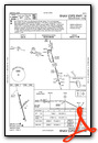
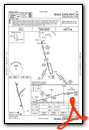
Instrument Approach Procedure (IAP) Charts
Nearby Airports with Instrument Procedures
| ID | Name | Heading / Distance | ||
|---|---|---|---|---|
 |
KCRZ | Corning Municipal Airport | 264° | 17.9 |
|
KGFZ | Greenfield Municipal Airport | 348° | 18.7 |
|
3Y3 | Winterset Municipal Airport | 037° | 25.7 |
|
I75 | Osceola Municipal Airport | 086° | 30.7 |
|
KLWD | Lamoni Municipal Airport | 137° | 31.4 |
|
KICL | Schenck Field Airport | 239° | 35.1 |
|
KAIO | Atlantic Municipal Airport | 306° | 38.6 |
|
KGCT | Guthrie County Regional Airport | 355° | 40.0 |
|
KRDK | Red Oak Municipal Airport | 269° | 40.7 |
|
KDSM | Des Moines International Airport | 045° | 44.1 |
|
KCNC | Chariton Municipal Airport | 089° | 45.6 |
|
KEVU | Northwest Missouri Regional Airport | 212° | 47.4 |
Airport Images

By: Bandco


