Login
Register


ICL
Schenck Field Airport
Official FAA Data Effective 2026-01-22 0901Z
Chart Supplement

VFR Chart of KICL
Sectional Charts at SkyVector.com
IFR Chart of KICL
Enroute Charts at SkyVector.com
Location Information for KICL
Coordinates: N40°43.33' / W95°1.60'Located 01 miles SE of Clarinda, Iowa on 323 acres of land. View all Airports in Iowa.
Surveyed Elevation is 995 feet MSL.
Operations Data
|
|
Airport Communications
| AWOS-3: | 132.025 Tel. 712-542-3345 |
|---|---|
| CTAF: | 122.800 |
| UNICOM: | 122.800 |
| AWOS-3 at SDA (17.7 W): | 125.525 712-246-4021 |
| AWOS-3P at RDK (20.4 NW): | 123.925 712-623-3220 |
| AWOS-3PT at EVU (22.8 S): | 118.225 660-562-9980 |
- APCH/DEP SVC PRVDD BY MINNEAPOLIS ARTCC ON FREQS 119.6/290.4 (OMAHA RCAG).
Nearby Navigation Aids
|
| ||||||||||||||||||||||||||||||||||||||||||||||||||||||


Runway 02/20
| Dimensions: | 5002 x 75 feet / 1525 x 23 meters | |
|---|---|---|
| Surface: | Concrete in Good Condition | |
| Weight Limits: | 7 /R/B/W/T, S-12 | |
| Edge Lighting: | Medium Intensity | |
| Runway 02 | Runway 20 | |
| Coordinates: | N40°42.91' / W95°1.84' | N40°43.66' / W95°1.39' |
| Elevation: | 990.7 | 995.0 |
| Traffic Pattern: | Left | Left |
| Runway Heading: | 24° True | 204° True |
| Markings: | Non-Precision Instrument in good condition. | Non-Precision Instrument in good condition. |
| Glide Slope Indicator | P2L (3.00° Glide Path Angle) | P2L (3.00° Glide Path Angle) |
| REIL: | Yes | |
| Obstacles: | 13 ft Road 475 ft from runway, 280 ft right of center | 99 ft Building 2570 ft from runway, 155 ft left of center |
Runway 13/31
| Dimensions: | 2729 x 280 feet / 832 x 85 meters | |
|---|---|---|
| Surface: | Turf in Fair Condition | |
| Runway 13 | Runway 31 | |
| Coordinates: | N40°43.59' / W95°1.75' | N40°43.24' / W95°1.38' |
| Elevation: | 995.8 | 982.5 |
| Traffic Pattern: | Left | Left |
| Runway Heading: | 141° True | 321° True |
Services Available
| Fuel: | 100LL (blue), Jet-A |
|---|---|
| Transient Storage: | Tiedowns |
| Airframe Repair: | MINOR |
| Engine Repair: | MINOR |
| Bottled Oxygen: | NONE |
| Bulk Oxygen: | NONE |
| Other Services: | CROP DUSTING SERVICES |
Ownership Information
| Ownership: | Publicly owned | |
|---|---|---|
| Owner: | CITY OF CLARINDA | GARY MC CLARNON, CITY MGR, 712-542-2136. |
| P.O. BOX 339 | ||
| CLARINDA, IA 51632 | ||
| 712-542-2136 | ||
| Manager: | MILO BEERY | |
| 3042 - 210TH STREET | ||
| CLARINDA, IA 51632 | ||
| 712-542-3010 | ||
Other Remarks
- FOR CD CTC MINNEAPOLIS ARTCC AT 651-463-5588.
- MKD WITH YELLOW CONES.
- MKD WITH YELLOW CONES.
- ACTVT MIRL RY 02/20; REIL RY 20 AND PAPI RY 02 & 20 - CTAF.
Weather Minimums


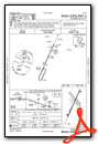
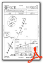
Instrument Approach Procedure (IAP) Charts
Nearby Airports with Instrument Procedures
| ID | Name | Heading / Distance | ||
|---|---|---|---|---|
 |
KSDA | Shenandoah Municipal Airport | 275° | 17.7 |
|
KRDK | Red Oak Municipal Airport | 328° | 20.3 |
|
KCRZ | Corning Municipal Airport | 037° | 20.5 |
|
KEVU | Northwest Missouri Regional Airport | 167° | 22.7 |
|
K57 | Gould Peterson Municipal Airport | 223° | 22.8 |
|
KCSQ | Creston Municipal Airport | 059° | 35.1 |
|
KAFK | Nebraska City Municipal Airport | 260° | 39.0 |
|
K01 | Farington Field Airport | 240° | 40.2 |
|
KAIO | Atlantic Municipal Airport | 358° | 40.9 |
|
KPMV | Plattsmouth Municipal/Douglas V Duey Field Airport | 288° | 42.8 |
|
KGFZ | Greenfield Municipal Airport | 035° | 44.9 |
|
KCBF | Council Bluffs Municipal Airport | 314° | 46.3 |
Airport Images
Do you have a recent image of this airport? Upload it here!


