Login
Register


CVN
Clovis Regional Airport
Official FAA Data Effective 2026-02-19 0901Z
Chart Supplement

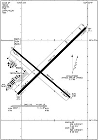
KCVN Airport Diagram
VFR Chart of KCVN
Sectional Charts at SkyVector.com
IFR Chart of KCVN
Enroute Charts at SkyVector.com
Location Information for KCVN
Coordinates: N34°25.60' / W103°4.65'Located 06 miles E of Clovis, New Mexico on 1480 acres of land. View all Airports in New Mexico.
Surveyed Elevation is 4215 feet MSL.
Operations Data
|
|
Airport Communications
| AWOS-3PT: | 135.375 Tel. 575-389-1056 |
|---|---|
| CANNON APPROACH: | 118.425 352.1 |
| CANNON DEPARTURE: | 118.425 307.175 |
| CLEARANCE DELIVERY: | 119.0 |
| CTAF: | 122.800 |
| UNICOM: | 122.800 |
| ATIS at CVS (12.4 W): | 269.9 |
| AWOS-3PT at PRZ (23.7 SW): | 118.175 575-478-2864 |
| ASOS at 4MR (35.5 W): | 135.375 575-784-2748 |
Nearby Navigation Aids
|
| ||||||||||||||||||||||||||||||||||||||||||||||||


Runway 04/22
| Dimensions: | 7200 x 150 feet / 2195 x 46 meters | |
|---|---|---|
| Surface: | Asphalt / Aggregate Friction Seal Coated in Good Condition | |
| Weight Limits: | S-45, D-57
PCR VALUE: 90/F/D/X/T
| |
| Edge Lighting: | Medium Intensity | |
| Runway 04 | Runway 22 | |
| Coordinates: | N34°25.33' / W103°5.05' | N34°26.16' / W103°4.03' |
| Elevation: | 4194.3 | 4214.2 |
| Traffic Pattern: | Left | Left |
| Runway Heading: | 46° True | 226° True |
| Markings: | Precision Instrument in good condition. | Non-Precision Instrument in good condition. |
| Glide Slope Indicator | P4L (3.00° Glide Path Angle) | P4L (3.00° Glide Path Angle) |
| Approach Lights: | MALSR 1,400 Foot Medium-intensity Approach Lighting System with runway alignment indicator lights. | |
| Obstacles: | 12 ft Road 250 ft from runway, 510 ft right of center +15 FT ROAD DIST 960 FT 600 FT R; 50:1 FM DTHR. |
|
Runway 12/30
| Dimensions: | 5697 x 100 feet / 1736 x 30 meters | |
|---|---|---|
| Surface: | Asphalt in Good Condition | |
| Weight Limits: | S-42, D-50
PCR VALUE: 60/F/D/X/T
| |
| Edge Lighting: | Medium Intensity | |
| Runway 12 | Runway 30 | |
| Coordinates: | N34°25.90' / W103°5.13' | N34°25.29' / W103°4.27' |
| Elevation: | 4215.8 | 4187.1 |
| Traffic Pattern: | Left | Left |
| Runway Heading: | 130° True | 310° True |
| Markings: | Non-Precision Instrument in good condition. | Non-Precision Instrument in good condition. |
| Glide Slope Indicator | P2L (4.00° Glide Path Angle) | P2L (4.00° Glide Path Angle) |
| REIL: | Yes | Yes |
| Obstacles: | 16 ft Road 820 ft from runway, 320 ft left of center | 10 ft Road 650 ft from runway, 280 ft right of center |
Runway 08/26
| Dimensions: | 2442 x 75 feet / 744 x 23 meters | |
|---|---|---|
| Surface: | Turf in Fair Condition | |
| Runway 08 | Runway 26 | |
| Coordinates: | N34°25.18' / W103°5.13' | N34°25.18' / W103°4.65' |
| Elevation: | 4195.7 | 4185.3 |
| Traffic Pattern: | Left | Left |
| Runway Heading: | 90° True | 270° True |
| Obstacles: | 47 ft Power Line 1783 ft from runway | |
Services Available
| Fuel: | 100LL (blue), Jet A+ |
|---|---|
| Transient Storage: | Hangars,Tiedowns |
| Airframe Repair: | NONE |
| Engine Repair: | NONE |
| Bottled Oxygen: | NOT AVAILABLE |
| Bulk Oxygen: | NOT AVAILABLE |
| Other Services: | CROP DUSTING SERVICES,AIR AMBULANCE SERVICES |
Ownership Information
| Ownership: | Publicly owned | |
|---|---|---|
| Owner: | CITY OF CLOVIS | |
| PO BOX 760 | ||
| CLOVIS, NM 88101 | ||
| (575) 769-7890 | ||
| Manager: | CHRIS MARSHALL | |
| 459 CR 11.5 | ||
| TEXICO, NM 88101 | ||
| 575-791-3175 | ||
Other Remarks
- CTN: JET TFC; CANNON AFB 13 NM SW.
- AGRICULTURE ACT ON & INVOF ARPT.
- FOR CD IF UNA TO CTC ON FSS FREQ, CTC ALBUQUERQUE ARTCC AT 505-856-4561.
- ACTVT MALSR RWY 04; REIL RWY 12 & 30; PAPI RWY 04 & 22; MIRL RWY 04/22 & 12/30 - CTAF. PAPI RWY 12 & 30 OPR CONSLY.
Weather Minimums
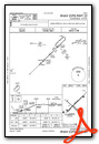
Instrument Approach Procedure (IAP) Charts


Nearby Airports with Instrument Procedures
| ID | Name | Heading / Distance | ||
|---|---|---|---|---|
 |
KCVS | Cannon AFB Airport | 257° | 12.4 |
|
KPRZ | Portales Municipal Airport | 224° | 23.6 |
|
2T1 | Muleshoe Municipal Airport | 123° | 26.1 |
|
KHRX | Hereford Municipal Airport | 054° | 45.4 |
|
KLIU | Littlefield Taylor Brown Municipal Airport | 131° | 45.7 |
|
KTCC | Tucumcari Municipal Airport | 330° | 52.2 |
|
KLLN | Levelland Municipal Airport | 145° | 63.1 |
|
KPVW | Hale County Airport | 102° | 69.4 |
|
F98 | Yoakum County Airport | 170° | 73.5 |
|
KTDW | Tradewind Airport | 053° | 76.2 |
|
KLBB | Lubbock Preston Smith International Airport | 125° | 77.6 |
|
KAMA | Rick Husband Amarillo International Airport | 054° | 82.7 |
Airport Images
Do you have a recent image of this airport? Upload it here!


Comments
Under New Management - No Self Serve
City of Clovis is now the FBO at the airport, they bought out Blue Sky. No self-serve pumps but there is currently no call-out fee for fuel.