Login
Register


TCC
Tucumcari Municipal Airport
Official FAA Data Effective 2025-12-25 0901Z
Chart Supplement

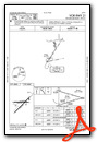
VFR Chart of KTCC
Sectional Charts at SkyVector.com
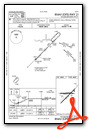
IFR Chart of KTCC
Enroute Charts at SkyVector.com
Location Information for KTCC
Coordinates: N35°10.97' / W103°36.19'Located 06 miles E of Tucumcari, New Mexico on 1160 acres of land. View all Airports in New Mexico.
Surveyed Elevation is 4064 feet MSL.
Operations Data
|
|
Airport Communications
| ASOS: | 119.275 Tel. 575-461-4940 |
|---|---|
| UNICOM: | 122.950 |
| CTAF: | 122.950 |
| ASOS at 4MR (42.0 S): | 135.375 575-784-2748 |
| ATIS at CVS (50.0 S): | 269.9 |
| AWOS-3PT at CVN (52.3 SE): | 135.375 575-389-1056 |
- APCH/DEP SVC PRVDD BY ALBUQUERQUE ARTCC (ZAB) ON FREQS 126.85/285.6 (TUCUMCARI RCAG).
Nearby Navigation Aids
|
| ||||||||||||||||||||||||||||||||||||||||||


Runway 03/21
| Dimensions: | 7104 x 100 feet / 2165 x 30 meters | |
|---|---|---|
| Surface: | Asphalt in Good Condition | |
| Weight Limits: | 10 /F/C/Y/T, S-25 | |
| Edge Lighting: | Medium Intensity | |
| Runway 03 | Runway 21 | |
| Coordinates: | N35°10.49' / W103°36.67' | N35°11.32' / W103°35.66' |
| Elevation: | 4039.7 | 4047.0 |
| Traffic Pattern: | Left | Left |
| Runway Heading: | 45° True | 225° True |
| Markings: | Non-Precision Instrument in poor condition. | Non-Precision Instrument in poor condition. |
| Glide Slope Indicator | V4L (3.00° Glide Path Angle) | |
Runway 08/26
| Dimensions: | 4600 x 60 feet / 1402 x 18 meters | |
|---|---|---|
| Surface: | Asphalt in Good Condition | |
| Weight Limits: | 6 /F/D/Y/T, S-12 | |
| Edge Lighting: | Medium Intensity | |
| Runway 08 | Runway 26 | |
| Coordinates: | N35°11.06' / W103°36.70' | N35°11.06' / W103°35.77' |
| Elevation: | 4064.9 | 4036.0 |
| Traffic Pattern: | Left | Left |
| Runway Heading: | 90° True | 270° True |
| Markings: | Non-Precision Instrument in fair condition. | Non-Precision Instrument in fair condition. |
Services Available
| Fuel: | 100LL (blue), Jet A+ |
|---|---|
| Transient Storage: | Hangars,Tiedowns FOR AVBL - AMGR. |
| Airframe Repair: | NOT AVAILABLE |
| Engine Repair: | NOT AVAILABLE |
| Bottled Oxygen: | NOT AVAILABLE |
| Bulk Oxygen: | NOT AVAILABLE |
| Other Services: | AIR AMBULANCE SERVICES |
Ownership Information
| Ownership: | Publicly owned | |
|---|---|---|
| Owner: | CITY OF TUCUMCARI | |
| BOX 1188 | ||
| TUCUMCARI, NM 88401 | ||
| 575-461-3451 | ||
| Manager: | JIM SEWELL | |
| 6352 QRA1 ROAD | ||
| TUCUMCARI, NM 88401 | ||
| 575-461-3229 | EMERG - 575-461-2280. | |
Other Remarks
- FOR CD IF UNA TO CTC ON FSS FREQ, CTC ALBUQUERQUE ARTCC AT 505-856-4561.
- AFT HR FUEL SELF SVC WITH CREDIT CARD.
- ACTVT VASI RWY 21; MIRL RWY 03/21 & 08/26 - CTAF.
Weather Minimums

Instrument Approach Procedure (IAP) Charts

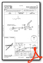
Nearby Airports with Instrument Procedures
| ID | Name | Heading / Distance | ||
|---|---|---|---|---|
 |
KCVS | Cannon AFB Airport | 163° | 49.9 |
|
KCVN | Clovis Regional Airport | 150° | 52.2 |
|
KPRZ | Portales Municipal Airport | 171° | 62.9 |
|
KHRX | Hereford Municipal Airport | 106° | 65.8 |
|
KDHT | Dalhart Municipal Airport | 045° | 72.1 |
|
2T1 | Muleshoe Municipal Airport | 141° | 76.4 |
|
KCAO | Clayton Municipal Airpark Airport | 016° | 78.9 |
|
KLVS | Las Vegas Municipal Airport | 290° | 80.6 |
|
KTDW | Tradewind Airport | 089° | 87.4 |
|
KDUX | Moore County Airport | 062° | 87.7 |
|
KAMA | Rick Husband Amarillo International Airport | 088° | 93.3 |
|
KLIU | Littlefield Taylor Brown Municipal Airport | 141° | 96.5 |
Airport Images
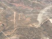
By: Big Orange Bird


Comments
Ground Transportation
No courtesy car, no taxi or cab. Transportation to motel by Quality Inn, Blue Swallow Motel or Roadrunner Lodge only.