Login
Register


HRX
Hereford Municipal Airport
Official FAA Data Effective 2026-01-22 0901Z
Chart Supplement

VFR Chart of KHRX
Sectional Charts at SkyVector.com
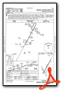
IFR Chart of KHRX
Enroute Charts at SkyVector.com
Location Information for KHRX
Coordinates: N34°51.64' / W102°19.55'Located 04 miles NE of Hereford, Texas on 601 acres of land. View all Airports in Texas.
Surveyed Elevation is 3787 feet MSL.
Operations Data
|
|
Airport Communications
| AWOS-3: | 118.05 Tel. 806-258-7283 |
|---|---|
| AMARILLO APPROACH: | 119.5 121.15 307.0 307.9 |
| AMARILLO DEPARTURE: | 119.5 121.15 307.0 307.9 |
| CTAF: | 122.800 |
| UNICOM: | 122.800 |
| AWOS-AV at TDW (30.8 NE): | 118.475 806-350-7407 |
| ATIS at AMA (37.3 NE): | 118.85 |
| ASOS at AMA (37.3 NE): | 118.85 806-223-2973 |
- APCH/DEP SVC PRVDD BY ALBUQUERQUE ARTCC (ZAB) ON FREQS 127.85/285.475 (AMARILLO RCAG) WHEN AMARILLO APCH CTL (AMA) CLSD.
Nearby Navigation Aids
|
| ||||||||||||||||||||||||||||||||||||||||||


Runway 02/20
| Dimensions: | 6100 x 100 feet / 1859 x 30 meters | |
|---|---|---|
| Surface: | Concrete / Grooved in Excellent Condition | |
| Edge Lighting: | Medium Intensity | |
| Runway 02 | Runway 20 | |
| Coordinates: | N34°51.32' / W102°19.76' | N34°52.21' / W102°19.17' |
| Elevation: | 3786.2 | 3786.2 |
| Runway Heading: | 29° True | 209° True |
| Markings: | Non-Precision Instrument in good condition. | Non-Precision Instrument in good condition. |
| Glide Slope Indicator | P4L (3.00° Glide Path Angle) | P4L (3.00° Glide Path Angle) |
| Obstacles: | 45 ft Power Line 2335 ft from runway, 596 ft left of center | |
Runway 14/32
| Dimensions: | 3807 x 135 feet / 1160 x 41 meters | |
|---|---|---|
| Surface: | Turf in Fair Condition | |
| Runway 14 | Runway 32 | |
| Coordinates: | N34°51.72' / W102°19.88' | N34°51.17' / W102°19.51' |
| Elevation: | 3783.0 | 3783.0 |
| Traffic Pattern: | Left | Left |
| Runway Heading: | 151° True | 331° True |
| Markings: | None in fair condition. | None in fair condition. |
| Obstacles: | 50 ft Power Line 1400 ft from runway, 280 ft right of center | 50 ft Power Line 1200 ft from runway |
Services Available
| Fuel: | 100LL (blue), Jet-A |
|---|---|
| Transient Storage: | Hangars,Tiedowns |
| Airframe Repair: | MAJOR |
| Engine Repair: | MAJOR |
| Bottled Oxygen: | NONE |
| Bulk Oxygen: | NONE |
| Other Services: | CROP DUSTING SERVICES,PILOT INSTRUCTION |
Ownership Information
| Ownership: | Publicly owned | |
|---|---|---|
| Owner: | CITY OF HEREFORD | |
| BOX 2277 | ||
| HEREFORD, TX 79045 | ||
| 806-363-7100 | ||
| Manager: | CAYDEN FINCH | |
| 4175 US HWY 60 | ||
| HEREFORD, TX 79045 | ||
| 806-344-7710 | ||
Other Remarks
- FOR CD CTC ALBUQUERQUE ARTCC AT 505-856-4861.
- THR MKD WITH 10 X 60 FT CONCRETE PAD ACRS END.
- THR MKD WITH 10 X 60 FT CONCRETE PAD ACRS END.
- 0LL 24 HRS SELF-SERVE.
- MIRL RWY 02/20 PRESET LOW INTST SS-SR. TO ACTVT MIRL 02/20 OR INCR INTST - CTAF. PAPI RWY 02 & 20 OPR CONSLY.
Weather Minimums

Instrument Approach Procedure (IAP) Charts

Nearby Airports with Instrument Procedures
| ID | Name | Heading / Distance | ||
|---|---|---|---|---|
 |
KTDW | Tradewind Airport | 052° | 30.8 |
|
KAMA | Rick Husband Amarillo International Airport | 054° | 37.3 |
|
2T1 | Muleshoe Municipal Airport | 201° | 43.4 |
|
KCVN | Clovis Regional Airport | 235° | 45.4 |
|
KPVW | Hale County Airport | 143° | 51.3 |
|
T45 | Panhandle-Carson County Airport | 057° | 56.0 |
|
KLIU | Littlefield Taylor Brown Municipal Airport | 183° | 56.2 |
|
KCVS | Cannon AFB Airport | 240° | 57.0 |
|
KDUX | Moore County Airport | 014° | 61.6 |
|
KTCC | Tucumcari Municipal Airport | 287° | 65.8 |
|
KBGD | Hutchinson County Airport | 042° | 68.0 |
|
KPRZ | Portales Municipal Airport | 231° | 68.8 |
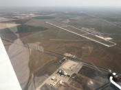
Airport Images

By: Big Orange Bird
By: Big Orange Bird


