Login
Register


DEC
Decatur Airport
Official FAA Data Effective 2026-02-19 0901Z
Chart Supplement

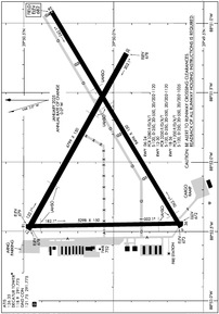
KDEC Airport Diagram
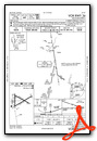
VFR Chart of KDEC
Sectional Charts at SkyVector.com
IFR Chart of KDEC
Enroute Charts at SkyVector.com
Location Information for KDEC
Coordinates: N39°50.07' / W88°51.94'Located 04 miles E of Decatur, Illinois on 2100 acres of land. View all Airports in Illinois.
Surveyed Elevation is 681 feet MSL.
Operations Data
|
|
Airport Communications
| ATIS: | 126.35 |
|---|---|
| ASOS: | Tel. 217-429-0052 |
| DECATUR TOWER: | 118.9 291.775 |
| DECATUR GROUND: | 121.75 291.775 |
| CHAMPAIGN APPROACH: | 132.85 290.225 |
| CHAMPAIGN DEPARTURE: | 132.85 290.225 |
| CTAF: | 118.900 |
| UNICOM: | 122.950 |
| AWOS-3PT at TAZ (28.1 SW): | 123.875 217-824-9323 |
| AWOS-3 at AAA (29.1 NW): | 118.775 217-732-9605 |
| ASOS at CMI (29.7 NE): | 217-355-4072 |
- APCH/DEP SVC PRVDD BY CHICAGO ARTCC ON FREQ 121.35 (REMOTED CHAMPAIGN APCH CTL) AND FREQ 353.95 (DANVILLE RCAG) WHEN CHAMPAIGN APCH CTL CLSD.
Nearby Navigation Aids
|
| ||||||||||||||||||||||||||||||||||||||||||||||||||||||||||||


Runway 06/24
| Dimensions: | 8496 x 150 feet / 2590 x 46 meters | |
|---|---|---|
| Surface: | Asphalt-Concrete / Grooved in Good Condition | |
| Weight Limits: | S-120, D-250, ST-550, DT-1120
PCR VALUE: 3280/F/D/X/T
| |
| Edge Lighting: | High Intensity | |
| Runway 06 | Runway 24 | |
| Coordinates: | N39°49.63' / W88°52.47' | N39°50.34' / W88°50.91' |
| Elevation: | 672.7 | 681.8 |
| Traffic Pattern: | Left | Left |
| Runway Heading: | 59° True | 239° True |
| Declared Distances: | TORA:8496 TODA:8496 ASDA:8496 LDA:8496 | TORA:8496 TODA:8496 ASDA:8496 LDA:8496 |
| Markings: | Precision Instrument in good condition. | Precision Instrument in fair condition. |
| Glide Slope Indicator | V4L (3.00° Glide Path Angle) | |
| RVR Equipment | Touchdown Midfield | Midfield Rollout |
| Approach Lights: | MALSR 1,400 Foot Medium-intensity Approach Lighting System with runway alignment indicator lights. | |
| Obstacles: | 17 ft Road 885 ft from runway, 599 ft left of center | |
Runway 12/30
| Dimensions: | 6799 x 150 feet / 2072 x 46 meters | |
|---|---|---|
| Surface: | Asphalt-Concrete / Grooved in Good Condition | |
| Weight Limits: | S-120, D-250, ST-550, DT-1120
PCR VALUE: 3250/F/D/X/T
| |
| Edge Lighting: | Medium Intensity | |
| Runway 12 | Runway 30 | |
| Coordinates: | N39°50.48' / W88°52.49' | N39°49.93' / W88°51.22' |
| Elevation: | 678.3 | 678.0 |
| Traffic Pattern: | Left | Left |
| Runway Heading: | 119° True | 299° True |
| Declared Distances: | TORA:6799 TODA:6799 ASDA:6799 LDA:6799 | TORA:6799 TODA:6799 ASDA:6799 LDA:6799 |
| Markings: | Non-Precision Instrument in good condition. | Non-Precision Instrument in fair condition. |
| Glide Slope Indicator | P4L (3.00° Glide Path Angle) | |
| Obstacles: | 43 ft Tree 1174 ft from runway, 288 ft right of center | |
Runway 18/36
| Dimensions: | 5298 x 150 feet / 1615 x 46 meters | |
|---|---|---|
| Surface: | Asphalt / Grooved in Good Condition | |
| Weight Limits: | S-120, D-250, ST-550, DT-1035
PCR VALUE: 1200/F/D/X/T
| |
| Edge Lighting: | Medium Intensity | |
| Runway 18 | Runway 36 | |
| Coordinates: | N39°50.49' / W88°52.46' | N39°49.61' / W88°52.45' |
| Elevation: | 678.9 | 672.2 |
| Traffic Pattern: | Left | Left |
| Runway Heading: | 179° True | 359° True |
| Declared Distances: | TORA:5298 TODA:5298 ASDA:5298 LDA:5298 | TORA:5298 TODA:5298 ASDA:5298 LDA:5298 |
| Markings: | Non-Precision Instrument in good condition. | Non-Precision Instrument in good condition. |
| Glide Slope Indicator | P4L (3.00° Glide Path Angle) | V4L (3.00° Glide Path Angle) |
| Obstacles: | 55 ft Trees 1755 ft from runway, 15 ft right of center | 50 ft Pole 2344 ft from runway, 461 ft left of center |
Services Available
| Fuel: | 100LL (blue), Jet-A |
|---|---|
| Transient Storage: | Hangars,Tiedowns |
| Airframe Repair: | NOT AVAILABLE |
| Engine Repair: | NOT AVAILABLE |
| Bottled Oxygen: | NOT AVAILABLE |
| Bulk Oxygen: | NOT AVAILABLE |
| Other Services: | AIR FREIGHT SERVICES,CHARTER SERVICE,PILOT INSTRUCTION,AIRCRAFT RENTAL,AIRCRAFT SALES |
Ownership Information
| Ownership: | Publicly owned | |
|---|---|---|
| Owner: | DECATUR PARK DISTRICT | |
| 620 E. RIVERSIDE AVE. | ||
| DECATUR, IL 62521 | ||
| 217-428-2423 | ||
| Manager: | TIM A. WRIGHT | |
| 910 S. AIRPORT ROAD | ||
| DECATUR, IL 62521 | ||
| 217-428-2423 | ||
Other Remarks
- N RAMP FROM HNGR B TO HNGR G CLSD TO ACFT OVR 12500 LBS.
- (LAHSO_ALD, RWY 24) SECONDARY LAHSO 8000 FT HOLD SHORT OF RWY 18/36.
- (CONTACT TITLE) 217-428-8836
- WHEN ATCT CLSD BE ALERT FOR VEHICULAR TFC IN ARPT OPS AREAS.
- BIRDS & WILDLIFE ON & INVOF ARPT.
- GLIDER OPS RWY 06 & 30 ONLY, RQR WRITTEN APVL - CTC AMGR. SOD OPS NA.
- SNOW REMOVAL OPS WINTER MONTHS MNT CTAF. LNDG/DEP ACFT USE CTAF WHEN ATCT CLSD.
- FOR US CUSTOMS CALL 217-425-4803.
- RWY 12 & 18 AND RWY 06 & 36 CLOSELY ALIGNED. VFY CORRECT RWY AND COMPASS HDG PRIOR TO DEP.
- TWY A RSTRD NORTH OF TWY G TO ACFT WITH WINGSPAN OF 86FT OR LESS WITHOUT PPR - CTC AMGR.
- FOR CD IF UNA TO CTC ON FSS FREQ, CTC CHICAGO ARTCC 630-906-8921.
- ACTVT MALSR RWY 06; MIRL RWY 12/30 & 18/36; TWY LGTS RWY 06 - CTAF. WHEN ATCT CLSD HIRL RWY 06/24 PRESET LOW INTST; INCR INTST - CTAF.
Weather Minimums


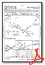
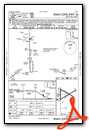
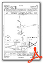
Instrument Approach Procedure (IAP) Charts


Nearby Airports with Instrument Procedures
| ID | Name | Heading / Distance | ||
|---|---|---|---|---|
 |
2H0 | Shelby County Airport | 177° | 25.4 |
|
KTAZ | Taylorville Municipal Airport | 230° | 28.1 |
|
KAAA | Logan County Airport | 312° | 29.1 |
|
KCMI | University of Illinois/Willard Airport | 065° | 29.8 |
|
KMTO | Coles County Memorial Airport | 128° | 34.6 |
|
C16 | Frasca Field Airport | 058° | 36.0 |
|
KSPI | Abraham Lincoln Capital Airport | 271° | 37.5 |
|
KBMI | Central Il Regional/Bloomington-Normal Airport | 356° | 38.6 |
|
KTIP | Rantoul Ntl Avn Cntr-Frank Elliott Field Airport | 050° | 43.2 |
|
1H2 | Effingham County Regional Airport | 161° | 48.3 |
|
1C1 | Paxton Airport | 042° | 50.1 |
|
1H8 | Casey Municipal Airport | 128° | 51.1 |
Airport Images

By: dfberns


