Login
Register


CMI
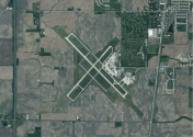
University of Illinois/Willard Airport
Official FAA Data Effective 2025-11-27 0901Z
Chart Supplement

KCMI Airport Diagram

VFR Chart of KCMI
Sectional Charts at SkyVector.com
IFR Chart of KCMI
Enroute Charts at SkyVector.com
Location Information for KCMI
Coordinates: N40°2.31' / W88°16.59'Located 05 miles SW of Champaign/Urbana, Illinois on 1799 acres of land. View all Airports in Illinois.
Surveyed Elevation is 754 feet MSL.
Operations Data
|
|
Airport Communications
| ATIS: | 124.85 |
|---|---|
| ASOS: | Tel. 217-355-4072 |
| CHAMPAIGN TOWER: | 120.4 127.825 229.4 |
| CHAMPAIGN GROUND: | 121.8 |
| CHAMPAIGN APPROACH: | 121.35 ;319-138 132.85 ;139-318 133.975 285.65 ;319-138 290.225 ;139-318 |
| CHAMPAIGN DEPARTURE: | 121.35 ;319-138 132.85 ;139-318 133.975 285.65 ;319-138 290.225 ;139-318 |
| IC: | 121.35 ;319-138 132.85 ;139-318 285.65 ;319-138 290.225 ;139-318 |
| CLEARANCE DELIVERY: | 128.75 |
| UNICOM: | 122.950 |
| EMERG: | 121.5 243.0 |
| CTAF: | 120.400 |
| CLASS C: | 121.35 ;319-138 132.85 ;139-318 285.65 ;319-138 290.225 ;139-318 |
| AWOS-3 at TIP (16.5 N): | 119.025 217-892-4999 |
| ASOS at DEC (29.8 SW): | 217-429-0052 |
| ATIS at DEC (29.8 SW): | 126.35 |
- APCH/DEP SVC PRVDD BY CHICAGO ARTCC ON REMOTED CHAMPAIGN APCH CTL FREQS 121.35 & 353.95 (DANVILLE RCAG) WHEN CHAMPAIGN APCH CTL CLSD.
- PRACTICE.
Nearby Navigation Aids
|
| ||||||||||||||||||||||||||||||||||||||||||||||||||||||||||||


Runway 14L/32R
| Dimensions: | 8101 x 150 feet / 2469 x 46 meters | |
|---|---|---|
| Surface: | Asphalt-Concrete / Grooved in Fair Condition | |
| Weight Limits: | S-120, D-403, ST-250, DT-900
PCR VALUE: 900/R/D/W/T
| |
| Edge Lighting: | High Intensity | |
| Runway 14L | Runway 32R | |
| Coordinates: | N40°2.84' / W88°17.14' | N40°1.89' / W88°15.93' |
| Elevation: | 754.9 | 749.4 |
| Traffic Pattern: | Left | Left |
| Runway Heading: | 136° True | 316° True |
| Declared Distances: | TORA:8101 TODA:8101 ASDA:8101 LDA:8101 | TORA:8101 TODA:8101 ASDA:8101 LDA:8101 |
| Markings: | Precision Instrument in fair condition. | Precision Instrument in fair condition. |
| Glide Slope Indicator | P4L (3.00° Glide Path Angle) | P4L (3.00° Glide Path Angle) |
| RVR Equipment | Touchdown Rollout | Touchdown Rollout |
| Approach Lights: | MALSR 1,400 Foot Medium-intensity Approach Lighting System with runway alignment indicator lights. | |
Runway 04/22
| Dimensions: | 6502 x 150 feet / 1982 x 46 meters | |
|---|---|---|
| Surface: | Asphalt / Grooved in Excellent Condition | |
| Weight Limits: | S-120, D-259, ST-193, DT-714
PCR VALUE: 600/F/D/X/T
| |
| Edge Lighting: | Medium Intensity | |
| Runway 04 | Runway 22 | |
| Coordinates: | N40°1.91' / W88°17.12' | N40°2.72' / W88°16.21' |
| Elevation: | 751.1 | 746.4 |
| Traffic Pattern: | Left | Left |
| Runway Heading: | 41° True | 221° True |
| Declared Distances: | TORA:6502 TODA:6502 ASDA:6502 LDA:6502 | TORA:6502 TODA:6502 ASDA:6502 LDA:6502 |
| Markings: | Non-Precision Instrument in good condition. | Non-Precision Instrument in good condition. |
| Obstacles: | 53 ft Tree 1687 ft from runway, 279 ft left of center | |
Runway 14R/32L
RWY 14R/32L NOT AVBL FOR PART 121/PART 380 OPS WITH SKED PAX CARRYING OPS MORE THAN 9 PAX SEATS AND NON-SKED PAX CARRYING OPS MORE THAN 30 PAX SEATS. CLSD 2300-0600 & TO ACFT ABV 12500 LB. | ||
| Dimensions: | 3816 x 75 feet / 1163 x 23 meters | |
|---|---|---|
| Surface: | Asphalt in Good Condition | |
| Weight Limits: | S-37, ST-53
PCR VALUE: 140/F/D/X/T
| |
| Edge Lighting: | Medium Intensity | |
| Runway 14R | Runway 32L | |
| Coordinates: | N40°2.43' / W88°16.87' | N40°1.98' / W88°16.30' |
| Elevation: | 750.1 | 743.1 |
| Runway Heading: | 136° True | 316° True |
| Declared Distances: | TORA:3816 TODA:3816 ASDA:3816 LDA:3816 | TORA:3816 TODA:3816 ASDA:3816 LDA:3816 |
| Markings: | Basic in fair condition. | Basic in fair condition. |
| Glide Slope Indicator | P4L (3.00° Glide Path Angle) | P4L (3.00° Glide Path Angle) |
Services Available
| Fuel: | 100LL (blue), Jet A-1+ |
|---|---|
| Transient Storage: | Tiedowns |
| Airframe Repair: | MAJOR |
| Engine Repair: | MAJOR |
| Bottled Oxygen: | NONE |
| Bulk Oxygen: | HIGH |
| Other Services: | AVIONICS,CHARTER SERVICE,PILOT INSTRUCTION,ANNUAL SURVEYING |
Ownership Information
| Ownership: | Publicly owned | |
|---|---|---|
| Owner: | UNIV OF ILLINOIS | |
| 11 AIRPORT ROAD | ||
| SAVOY, IL 61874 | ||
| 217-244-8604 | ||
| Manager: | TIMOTHY BANNON | |
| 11 AIRPORT RD | ||
| SAVOY, IL 61874 | ||
| 217-244-8604 | ||
Other Remarks
- TSNT PRKG ON SE GA APN.
- OPS HR H24; ATNDD CONSLY.
- BIRDS ON & INVOF ARPT.
- TWY E & D SW OF RWY 14L/32R CLSD TO ACFT ABV 11800 LB.
- TWY A2 & A3 ADJ TO ACR APN NOT VSB FM ATCT.
- RWY 22 & 32R ENDS NOT VSB FM EACH OTR.
- FOR CD IF UNA TO CTC ON FSS FREQ, CTC CHICAGO ARTCC AT 630-906-8921.
- RWY 32R CALM WIND RWY WHEN ATCT CLSD.
- WHEN ATCT CLSD ACTVT MALSR RWY 32R; PAPI RWY 14L/32R; MIRL RWY 04/22; HIRL RWY 14L/32R - CTAF. HIRL RWY 14L/32R PRESET TO LOW INTST; INCR INTST - CTAF.
- 2 HR PPR - 217-729-7607.
Weather Minimums

Instrument Approach Procedure (IAP) Charts


Nearby Airports with Instrument Procedures
| ID | Name | Heading / Distance | ||
|---|---|---|---|---|
 |
C16 | Frasca Field Airport | 029° | 7.4 |
|
KTIP | Rantoul Ntl Avn Cntr-Frank Elliott Field Airport | 021° | 16.5 |
|
1C1 | Paxton Airport | 015° | 25.5 |
|
KDEC | Decatur Airport | 245° | 29.8 |
|
KDNV | Vermilion Regional Airport | 072° | 32.8 |
|
KMTO | Coles County Memorial Airport | 180° | 33.6 |
|
KPRG | Edgar County Airport | 125° | 34.6 |
|
KBMI | Central Il Regional/Bloomington-Normal Airport | 312° | 39.4 |
|
2H0 | Shelby County Airport | 215° | 45.9 |
|
1H8 | Casey Municipal Airport | 163° | 45.9 |
|
KAAA | Logan County Airport | 278° | 49.3 |
|
3I3 | Sky King Airport | 124° | 50.9 |
Airport Images
By: DevonH


