Login
Register


TIP
Rantoul Ntl Avn Cntr-Frank Elliott Field Airport
Official FAA Data Effective 2025-11-27 0901Z
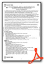
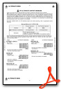
Chart Supplement

VFR Chart of KTIP
Sectional Charts at SkyVector.com
IFR Chart of KTIP
Enroute Charts at SkyVector.com
Location Information for KTIP
Coordinates: N40°17.61' / W88°8.54'Located 00 miles N of Rantoul, Illinois on 1192 acres of land. View all Airports in Illinois.
Surveyed Elevation is 737 feet MSL.
Operations Data
|
|
Airport Communications
| AWOS-3: | 119.025 Tel. 217-892-4999 |
|---|---|
| CHAMPAIGN APPROACH: | 121.35 285.65 |
| CHAMPAIGN DEPARTURE: | 121.35 285.65 |
| CTAF: | 123.000 |
| UNICOM: | 123.000 |
| ATIS at CMI (16.5 S): | 124.85 |
| ASOS at CMI (16.8 S): | 217-355-4072 |
| AWOS-3 at DNV (25.7 E): | 119.275 217-442-4660 |
- APCH/DEP SVC PRVDD BY CHICAGO ARTCC ON REMOTED CHAMPAIGN APCH CTL FREQS 121.35 & 353.95 (DANVILLE RCAG) WHEN CHAMPAIGN APCH CTL CLSD.
Nearby Navigation Aids
|
| ||||||||||||||||||||||||||||||||||||||||||||||||||||||||||||


Runway 09/27
| Dimensions: | 5001 x 75 feet / 1524 x 23 meters | |
|---|---|---|
| Surface: | Asphalt in Good Condition | |
| Edge Lighting: | Medium Intensity | |
| Runway 09 | Runway 27 | |
| Coordinates: | N40°17.52' / W88°8.99' | N40°17.52' / W88°7.92' |
| Elevation: | 735.2 | 728.6 |
| Traffic Pattern: | Right | |
| Runway Heading: | 90° True | 270° True |
| Markings: | Non-Precision Instrument in fair condition. | Non-Precision Instrument in fair condition. |
| Glide Slope Indicator | P4L (3.00° Glide Path Angle) | P4L (3.00° Glide Path Angle) |
| REIL: | Yes | Yes |
Runway 18/36
| Dimensions: | 4894 x 75 feet / 1492 x 23 meters | |
|---|---|---|
| Surface: | Asphalt in Good Condition | |
| Edge Lighting: | Medium Intensity | |
| Runway 18 | Runway 36 | |
| Coordinates: | N40°18.11' / W88°8.63' | N40°17.30' / W88°8.63' |
| Elevation: | 737.4 | 733.3 |
| Traffic Pattern: | Right | |
| Runway Heading: | 180° True | 360° True |
| Markings: | Non-Precision Instrument in fair condition. | Non-Precision Instrument in fair condition. |
Services Available
| Fuel: | 100LL (blue), Jet-A |
|---|---|
| Transient Storage: | Hangars |
| Airframe Repair: | NONE |
| Engine Repair: | NONE |
| Bottled Oxygen: | NONE |
| Bulk Oxygen: | NONE |
| Other Services: | AIR FREIGHT SERVICES,CROP DUSTING SERVICES,CHARTER SERVICE,GLIDER SERVICE,PILOT INSTRUCTION,AIRCRAFT RENTAL,AIRCRAFT SALES |
Ownership Information
| Ownership: | Publicly owned | |
|---|---|---|
| Owner: | VILLAGE OF RANTOUL | |
| 333 SOUTH TANNER STREET, PO BOX 38 | ||
| RANTOUL, IL 61866 | ||
| 217-892-6800 | ||
| Manager: | BOB COVERDILL | |
| 333 S. TANNER, P.O BOX 38 | ||
| RANTOUL, IL 61866-0038 | ||
| 217-892-6895 | ||
Other Remarks
- FBO OPNS MON-FRI 0700-1600. FBO SVC CLSD SAT+SUN UNLESS ADVN COORDINATION IS MADE.
- DEER & BIRDS ON AND INVOF ARPT. SEASONAL MOWING OPS ADJ TO RYS & TWYS.
- TWY 35 FT WIDE IN MOST PLACES. 48 HRS PPR FOR ACFT WITH SINGLE WHEEL LOAD GREATER THAN 15,000 LBS.
- FOR CD CTC CHAMPAIGN APCH AT 217-355-4071, WHEN APCH CLSD CTC CHICAGO ARTCC AT 630-906-8921
- 0LL FOR FUEL AFTER HRS CALL PHONE NUMBER POSTED ON SITE.
- TO INCR INTST & ACTVT MIRL RYS 09/27 & 18/36, REILS RYS 09/27 - CTAF. PAPI RY 09 & 27 OPR CONTINUOUSLY.
Weather Minimums
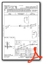
Instrument Approach Procedure (IAP) Charts


Nearby Airports with Instrument Procedures
| ID | Name | Heading / Distance | ||
|---|---|---|---|---|
 |
C16 | Frasca Field Airport | 196° | 9.2 |
|
1C1 | Paxton Airport | 004° | 9.3 |
|
KCMI | University of Illinois/Willard Airport | 202° | 16.5 |
|
KDNV | Vermilion Regional Airport | 102° | 25.8 |
|
KBMI | Central Il Regional/Bloomington-Normal Airport | 287° | 37.1 |
|
KPRG | Edgar County Airport | 148° | 41.7 |
|
50I | Kentland Municipal Airport | 049° | 42.9 |
|
KDEC | Decatur Airport | 230° | 43.2 |
|
KPNT | Pontiac Municipal Airport | 329° | 43.8 |
|
KIKK | Greater Kankakee Airport | 016° | 48.6 |
|
KMTO | Coles County Memorial Airport | 187° | 49.3 |
|
KAAA | Logan County Airport | 261° | 55.4 |
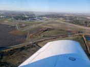
Airport Images
")
By: 2flaps
By: andersonmanly


