Login
Register


EIK
Erie Municipal Airport
Official FAA Data Effective 2026-01-22 0901Z
Chart Supplement

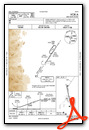
VFR Chart of KEIK
Sectional Charts at SkyVector.com
IFR Chart of KEIK
Enroute Charts at SkyVector.com
Location Information for KEIK
Coordinates: N40°0.61' / W105°2.88'Located 03 miles S of Erie, Colorado on 115 acres of land. View all Airports in Colorado.
Surveyed Elevation is 5119 feet MSL.
Operations Data
|
|
Airport Communications
| AWOS-3PT: | 133.825 Tel. 303-604-4339 |
|---|---|
| DENVER APPROACH: | 125.125 263.025 |
| DENVER DEPARTURE: | 125.125 263.025 |
| CTAF: | 123.000 |
| UNICOM: | 123.000 |
| ATIS at BJC (6.9 SW): | 126.25 |
| AWOS-3 at BJC (6.9 SW): | 720-887-8067 |
| AWOS-3 at BDU (8.4 W): | 118.825 303-541-9540 |
Nearby Navigation Aids
|
| ||||||||||||||||||||||||||||||||||||||||||


Runway 16/34
-2 FT TRRN 60 - 70 FT E OF CNTRLN FULL LEN. | ||
| Dimensions: | 4700 x 60 feet / 1433 x 18 meters | |
|---|---|---|
| Surface: | Concrete in Good Condition | |
| Weight Limits: | S-12 | |
| Edge Lighting: | Medium Intensity | |
| Runway 16 | Runway 34 | |
| Coordinates: | N40°0.99' / W105°3.00' | N40°0.24' / W105°2.77' |
| Elevation: | 5075.5 | 5119.4 |
| Traffic Pattern: | Right | |
| Runway Heading: | 167° True | 347° True |
| Markings: | Non-Precision Instrument in good condition. | Non-Precision Instrument in good condition. |
| Glide Slope Indicator | P2L (3.00° Glide Path Angle) | P2L (3.00° Glide Path Angle) |
| REIL: | Yes | |
| Obstacles: | 78 ft Tree 1522 ft from runway, 422 ft left of center | |
Services Available
| Fuel: | 100LL (blue), Jet-A |
|---|---|
| Transient Storage: | Hangars,Tiedowns |
| Airframe Repair: | MAJOR |
| Engine Repair: | MAJOR |
| Bottled Oxygen: | HIGH/LOW |
| Bulk Oxygen: | NOT AVAILABLE |
| Other Services: | PILOT INSTRUCTION,AIRCRAFT RENTAL,AIRCRAFT SALES |
Ownership Information
| Ownership: | Publicly owned | |
|---|---|---|
| Owner: | TOWN OF ERIE | |
| PO BOX 750 | ||
| ERIE, CO 80516 | ||
| 303-926-2870 | ||
| Manager: | JASON HURD | |
| 395 AIRPORT DRIVE | ||
| ERIE, CO 80516 | ||
| 303-664-0633 | ||
Other Remarks
- AFT HR EMERG - 303-870-5659.
- TWY A LGTD.
- FOR CD CTC DENVER APCH AT 303-342-1916.
- -2 TO -6 FT DITCH WI 700 FT OF RWY END VARIOUS LOCATIONS.
- 30 FT ROAD 1350 FT FM THR BOTH SIDES; -6 TO -12 FT DITCH 60 FT L OF CNTRLN PARL TO FIRST 750 FT OF RWY.
- 0LL SELF SVC AVBL H24 WITH CREDIT CARD.
- ACTVT REIL RWY 16; PAPI RWY 16 & 34; MIRL RWY 16/34 - CTAF.
Weather Minimums

Instrument Approach Procedure (IAP) Charts

Nearby Airports with Instrument Procedures
| ID | Name | Heading / Distance | ||
|---|---|---|---|---|
 |
KBJC | Rocky Mountain Metro Airport | 207° | 6.9 |
|
KLMO | Vance Brand Airport | 330° | 10.7 |
|
KDEN | Denver International Airport | 117° | 19.5 |
|
KBKF | Buckley Space Force Base Airport | 143° | 23.0 |
|
KFNL | Northern Colorado Regional Airport | 003° | 26.5 |
|
KCFO | Colorado Air and Space Port Airport | 119° | 27.2 |
|
KAPA | Centennial Airport | 160° | 27.9 |
|
KGXY | Greeley-Weld County Airport | 036° | 31.9 |
|
KGNB | Granby-Grand County Airport | 277° | 40.3 |
|
KFMM | Fort Morgan Municipal Airport | 070° | 60.4 |
|
20V | Mc Elroy Airfield Airport | 272° | 60.9 |
|
KFLY | Meadow Lake Airport | 160° | 67.7 |
Airport Images
Do you have a recent image of this airport? Upload it here!


