Login
Register
FNL
Northern Colorado Regional Airport
Official FAA Data Effective 2026-01-22 0901Z
VFR Chart of KFNL
Sectional Charts at SkyVector.com
IFR Chart of KFNL
Enroute Charts at SkyVector.com
Location Information for KFNL
Coordinates: N40°27.11' / W105°0.68'Located 09 miles SE of Fort Collins/Loveland, Colorado on 1065 acres of land. View all Airports in Colorado.
Surveyed Elevation is 5020 feet MSL.
Operations Data
|
|
Airport Communications
| ATIS: | 135.075 (970-669-9187) |
|---|---|
| AWOS-3PT: | 135.075 Tel. 970-669-9187 |
| NOCO TOWER: | 118.4 |
| NOCO GROUND: | 121.65 |
| DENVER APPROACH: | 134.85 251.125 |
| DENVER DEPARTURE: | 134.85 251.125 |
| CLEARANCE DELIVERY: | 120.25 ;WHEN FNL TWR CLSD. |
| CTAF: | 118.400 |
| POWDR STAR: | 120.35 379.3 |
| DANDD STAR: | 120.35 379.3 |
| QUAIL STAR: | 120.35 379.3 |
| TOMSN STAR: | 119.3 307.3 |
| LARKS STAR: | 379.3 |
| LARKS: | 120.35 |
| BRNKO RNAV STAR: | 127.05 363.25 |
| RAMMS STAR: | 120.35 379.3 |
| AWOS-3PT at GXY (17.4 E): | 135.175 970-352-3511 |
| AWOS-3 at LMO (18.6 SW): | 120.0 303-684-7545 |
| AWOS-3PT at EIK (26.6 S): | 133.825 303-604-4339 |
- (APCH/DEP CTL TYPE) DEN TRACON COORDS THRU SR2 (STLT RADAR 2).
- (APCH/DEP CTL TYPE) DEN TRACON COORDS THRU SR2 (STLT RADAR 2).
Nearby Navigation Aids
|
| ||||||||||||||||||||||||||||||||||||||||||
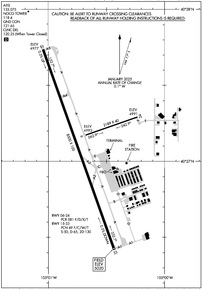
Runway 15/33
RWY 33 CALM WIND RWY 5 KTS OR LESS. | ||
| Dimensions: | 8500 x 100 feet / 2591 x 30 meters | |
|---|---|---|
| Surface: | Asphalt / Grooved in Good Condition | |
| Weight Limits: | 49 /F/C/W/T, S-50, D-65, ST-130 | |
| Edge Lighting: | High Intensity | |
| Runway 15 | Runway 33 | |
| Coordinates: | N40°27.74' / W105°1.04' | N40°26.42' / W105°0.43' |
| Elevation: | 4977.2 | 5020.3 |
| Traffic Pattern: | Left | Left |
| Runway Heading: | 160° True | 340° True |
| Declared Distances: | TORA:8500 TODA:8500 ASDA:8500 LDA:8500 | TORA:8500 TODA:8500 ASDA:8500 LDA:8500 |
| Markings: | Precision Instrument in good condition. | Precision Instrument in good condition. |
| Glide Slope Indicator | P4L (3.00° Glide Path Angle) | P4L (3.00° Glide Path Angle) |
| Approach Lights: | MALSR 1,400 Foot Medium-intensity Approach Lighting System with runway alignment indicator lights. | |
| REIL: | Yes | |
Runway 06/24
EDGE REFLECTORS FULL LEN. | ||
| Dimensions: | 2189 x 40 feet / 667 x 12 meters | |
|---|---|---|
| Surface: | Asphalt in Good Condition | |
| Runway 06 | Runway 24 | |
| Coordinates: | N40°27.17' / W105°0.68' | N40°27.29' / W105°0.23' |
| Elevation: | 4993.4 | 4991.3 |
| Traffic Pattern: | Left | Left |
| Runway Heading: | 71° True | 251° True |
| Declared Distances: | TORA:2189 TODA:2189 ASDA:2189 LDA:2189 | TORA:2189 TODA:2189 ASDA:2189 LDA:2189 |
| Markings: | Basic in good condition. | Basic in good condition. |
Services Available
| Fuel: | 100LL (blue), Jet-A |
|---|---|
| Transient Storage: | Hangars,Tiedowns |
| Airframe Repair: | MAJOR |
| Engine Repair: | MAJOR |
| Bottled Oxygen: | NOT AVAILABLE |
| Bulk Oxygen: | HIGH/LOW |
| Other Services: | CHARTER SERVICE,PILOT INSTRUCTION,AIRCRAFT RENTAL,AIRCRAFT SALES,ANNUAL SURVEYING |
Ownership Information
| Ownership: | Publicly owned | |
|---|---|---|
| Owner: | FORT COLLINS & LOVELAND | |
| 4900 EARHART ROAD | ||
| LOVELAND, CO 80538 | ||
| 970-962-2850 | ||
| Manager: | JOHN KINNEY | |
| 4900 EARHART ROAD | ||
| LOVELAND, CO 80538 | ||
| 970-962-2852 | ||
Other Remarks
- RSCD UNMON 0500-1300Z++
- FOR CD CTC DENVER APCH AT 303-342-1916.
- RWY 24 THLD NOT VISIBLE BY TWR.
- 0LL H24 WITH CREDIT CARD.
- H24 WITH CREDIT CARD.
- DUSK-DAWN: ACTVT MALSR RWY 33; REIL RWY 15; PAPI RWY 33; HIRL RWY 15/33; TWY LGTS - CTAF. PAPI RWY 15 ON CONSLY.
Weather Minimums
Standard Terminal Arrival (STAR) Charts
- BRNKO FOUR (RNAV)

- BRNKO FOUR (RNAV), CONT.1

- BRNKO FOUR (RNAV), CONT.2

- DANDD ONE

- DANDD ONE, CONT.1

- LANDR THREE

- LANDR THREE, CONT.1

- LARKS THREE

- LARKS THREE, CONT.1

- PINNR THREE (RNAV)

- PINNR THREE (RNAV), CONT.1

- POWDR ONE

- POWDR ONE, CONT.1

- QUAIL ONE

- RAMMS EIGHT

- RAMMS EIGHT, CONT.1

- TOMSN NINE

- TOMSN NINE, CONT.1

Instrument Approach Procedure (IAP) Charts
Departure Procedure (DP) Charts
- DENVER THREE

- DENVER THREE, CONT.1

- ECHOO ONE (RNAV)

- ECHOO ONE (RNAV), CONT.1

- MRSHH TWO (RNAV)

- MRSHH TWO (RNAV), CONT.1

- PIKES THREE

- PLAINS TWO

- PLAINS TWO, CONT.1

- ROCKIES SEVEN

- ROCKIES SEVEN, CONT.1

- SKYEE ONE (RNAV)

- SKYEE ONE (RNAV), CONT.1

- WNGSS ONE (RNAV)

- WNGSS ONE (RNAV), CONT.1

- YELLOWSTONE FIVE

- YELLOWSTONE FIVE, CONT.1

Nearby Airports with Instrument Procedures
| ID | Name | Heading / Distance | ||
|---|---|---|---|---|
 |
KGXY | Greeley-Weld County Airport | 092° | 17.3 |
 |
KLMO | Vance Brand Airport | 202° | 18.6 |
 |
KEIK | Erie Municipal Airport | 183° | 26.5 |
 |
KBJC | Rocky Mountain Metro Airport | 188° | 32.9 |
 |
KDEN | Denver International Airport | 156° | 38.7 |
 |
KCYS | Cheyenne Regional/Jerry Olson Field Airport | 012° | 43.2 |
 |
KCFO | Colorado Air and Space Port Airport | 151° | 45.6 |
 |
KBKF | Buckley Space Force Base Airport | 165° | 46.5 |
 |
KGNB | Granby-Grand County Airport | 242° | 46.9 |
 |
KAPA | Centennial Airport | 171° | 53.4 |
 |
KFMM | Fort Morgan Municipal Airport | 096° | 55.8 |
 |
82V | Pine Bluffs Municipal Airport | 043° | 58.0 |


Comments
KFNL Tower Update
KFNL is now a towered field. Tower freq is 118.4. It is a remote setup, so controllers will not always have you in sight, and will likely ask you to report certain positions.
Ryan R Zerr
KFNL Tower Update
Ground freq: 121.65
Tower freq: 118.5
KFNL Tower Update
KFNL NoCo Tower frequency is: 118.40, NoCo Ground is 121.65.
The mobile airbox "tower" does not have radar yet so controllers are only using binoculars. There are reporting points North and South of the Class E Airspace (see sectional).
William F. Snodgrass
Pages