Login
Register


DEN
Denver International Airport
Official FAA Data Effective 2026-01-22 0901Z
Chart Supplement

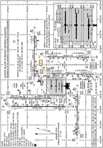
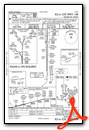
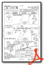
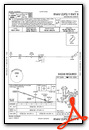
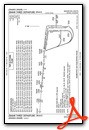
KDEN Airport Diagram
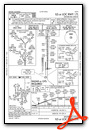
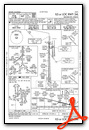
VFR Chart of KDEN
Sectional Charts at SkyVector.com
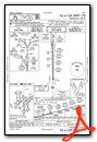
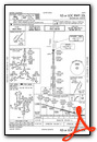
IFR Chart of KDEN
Enroute Charts at SkyVector.com
Location Information for KDEN
Coordinates: N39°51.70' / W104°40.39'Located 16 miles NE of Denver, Colorado on 33531 acres of land. View all Airports in Colorado.
Surveyed Elevation is 5433 feet MSL.
Operations Data
|
|
Airport Communications
| D-ATIS: | 125.6 ;ARR (303-342-0819) 134.025 ;DEP (303-342-0819) 379.9 ;ARR (303-342-0819) |
|---|---|
| ASOS: | Tel. 719-204-1223 |
| DENVER TOWER: | 124.3 ;RWY 17R/35L 128.75 ;RWY 07/25 132.35 ;RWY 08/26, 17L/35R 135.3 ;RWY 16L/34R, 16R/34L 239.275 ;RWY 08/26, 17L/35R 273.55 ;RWY 07/25 322.45 ;RWY 17R/35L 351.95 ;RWY 16L/34R, 16R/34L |
| DENVER GROUND: | 121.35 ;WEST 121.85 ;EAST 377.1 ;EAST 379.175 ;WEST |
| DENVER APPROACH: | 119.3 ;NORTH 120.35 ;SOUTH 124.95 ;NORTH 126.55 ;SOUTH 269.525 ;SOUTH 307.3 ;NORTH 346.4 ;NORTH 379.3 ;SOUTH |
| DENVER DEPARTURE: | 126.1 ;WEST 127.05 ;NORTH 128.25 ;EAST 128.45 ;SOUTH 251.075 ;SOUTH 360.75 ;WEST 363.25 ;NORTH 371.95 ;EAST |
| IC: | 119.3 ;NORTH 120.35 ;SOUTH 307.3 ;NORTH 379.3 ;SOUTH |
| CLEARANCE DELIVERY: | 118.75 |
| NIIXX STAR: | 126.55 269.525 |
| LAWGR STAR: | 124.95 346.4 |
| TOMSN STAR: | 119.3 307.3 |
| PINNR STAR: | 127.05 363.25 |
| POWDR STAR: | 120.35 379.3 |
| AALLE RNAV STAR: | 124.95 346.4 |
| DANDD STAR: | 120.35 379.3 |
| FINAL CTL: | 120.8 |
| UNICOM: | 122.950 |
| QUAIL STAR: | 120.35 379.3 |
| CLASH STAR: | 126.55 269.525 |
| LARKS: | 120.35 |
| SSKII STAR: | 120.35 379.3 |
| RAMMS STAR: | 120.35 379.3 |
| EMERG: | 121.5 243.0 |
| CLASS B: | 126.1 ;WEST 128.25 ;EAST 128.45 ;SOUTH 134.85 ;NORTH 251.075 ;SOUTH 251.125 ;NORTH 360.75 ;WEST 371.95 ;EAST |
| TBARR STAR: | 120.35 379.3 |
| FLATI STAR: | 119.3 307.3 |
| LARKS STAR: | 379.3 |
| LONGZ STAR: | 119.3 307.3 |
| LANDR STAR: | 124.95 346.4 |
| ATIS at CFO (7.8 SE): | 119.025 |
| AWOS-3 at CFO (7.8 SE): | 119.025 303-261-9104 |
| ATIS at BKF (10.3 S): | 259.3 |
- TA35 MINIMUM SAFE ALTITUDE WARNING (MSAW) ADVISORIES UNAVBL WITHIN 35 NM OF GRAND JUNCTION VORTAC BLO 14000 FT MSL.
- RY REDESIGNATION EFFECTIVE 28 NOV 02, CONSULT NOTAMS.
- ASDE-X IN USE. OPERATE TRANSPONDERS WITH ALTITUDE REPORTING MODE AND ADS-B (IF EQUIPPED) ENABLED ON ALL AIRPORT SURFACES.
Nearby Navigation Aids
|
| ||||||||||||||||||||||||||||||||||||||||||


Runway 16R/34L
| Dimensions: | 16000 x 200 feet / 4877 x 61 meters | |
|---|---|---|
| Surface: | Concrete / Grooved in Good Condition | |
| Weight Limits: | S-116, D-240, ST-515, DT-1085
PCR VALUE: 1050/R/B/W/T
| |
| Edge Lighting: | High Intensity | |
| Runway 16R | Runway 34L | |
| Coordinates: | N39°53.75' / W104°41.77' | N39°51.11' / W104°41.80' |
| Elevation: | 5321.8 | 5327.0 |
| Runway Heading: | 181° True | 1° True |
| Declared Distances: | TORA:16000 TODA:16000 ASDA:16000 LDA:16000 | TORA:16000 TODA:16000 ASDA:16000 LDA:16000 |
| Markings: | Precision Instrument in good condition. | Precision Instrument in good condition. |
| Glide Slope Indicator | P4R (3.00° Glide Path Angle) | P4L (3.00° Glide Path Angle) |
| RVR Equipment | Touchdown Midfield Rollout | Touchdown Midfield Rollout |
| Approach Lights: | MALSR 1,400 Foot Medium-intensity Approach Lighting System with runway alignment indicator lights. | ALSF2 Standard 2,400 Foot High-intensity Approach Lighting System with sequenced flashers, CATEGORY II or III Configuration. |
| Centerline Lights: | Yes | Yes |
Runway 07/25
| Dimensions: | 12000 x 150 feet / 3658 x 46 meters | |
|---|---|---|
| Surface: | Concrete / Grooved in Good Condition | |
| Weight Limits: | S-116, D-240, ST-515, DT-1085
PCR VALUE: 1050/R/B/W/T
| |
| Edge Lighting: | High Intensity | |
| Runway 07 | Runway 25 | |
| Coordinates: | N39°50.46' / W104°43.60' | N39°50.44' / W104°41.04' |
| Elevation: | 5350.2 | 5355.0 |
| Runway Heading: | 90° True | 271° True |
| Declared Distances: | TORA:12000 TODA:12000 ASDA:12000 LDA:12000 | TORA:12000 TODA:13000 ASDA:12000 LDA:12000 |
| Markings: | Precision Instrument in good condition. | Precision Instrument in good condition. |
| Glide Slope Indicator | P4R (3.00° Glide Path Angle) | P4L (3.00° Glide Path Angle) |
| RVR Equipment | Touchdown Rollout | Touchdown Rollout |
| Approach Lights: | MALSR 1,400 Foot Medium-intensity Approach Lighting System with runway alignment indicator lights. | MALSR 1,400 Foot Medium-intensity Approach Lighting System with runway alignment indicator lights. |
| Centerline Lights: | Yes | Yes |
| Obstacles: | 117 ft Pole 5100 ft from runway, 500 ft left of center | |
Runway 08/26
| Dimensions: | 12000 x 150 feet / 3658 x 46 meters | |
|---|---|---|
| Surface: | Concrete / Grooved in Good Condition | |
| Weight Limits: | S-116, D-240, ST-515, DT-1085
PCR VALUE: 1050/R/B/W/T
| |
| Edge Lighting: | High Intensity | |
| Runway 08 | Runway 26 | |
| Coordinates: | N39°52.65' / W104°39.73' | N39°52.63' / W104°37.17' |
| Elevation: | 5354.3 | 5294.4 |
| Runway Heading: | 91° True | 271° True |
| Declared Distances: | TORA:12000 TODA:13000 ASDA:12000 LDA:12000 | TORA:12000 TODA:12000 ASDA:12000 LDA:12000 |
| Markings: | Precision Instrument in good condition. | Precision Instrument in good condition. |
| Glide Slope Indicator | P4L (3.00° Glide Path Angle) | P4L (3.00° Glide Path Angle) |
| RVR Equipment | Touchdown Rollout | Touchdown Rollout |
| Approach Lights: | MALSR 1,400 Foot Medium-intensity Approach Lighting System with runway alignment indicator lights. | MALSR 1,400 Foot Medium-intensity Approach Lighting System with runway alignment indicator lights. |
| Centerline Lights: | Yes | Yes |
Runway 16L/34R
| Dimensions: | 12000 x 150 feet / 3658 x 46 meters | |
|---|---|---|
| Surface: | Concrete / Grooved in Good Condition | |
| Weight Limits: | S-116, D-240, ST-515, DT-1085
PCR VALUE: 1050/R/B/W/T
| |
| Edge Lighting: | High Intensity | |
| Runway 16L | Runway 34R | |
| Coordinates: | N39°53.82' / W104°41.21' | N39°51.85' / W104°41.23' |
| Elevation: | 5349.9 | 5353.7 |
| Runway Heading: | 181° True | 1° True |
| Declared Distances: | TORA:12000 TODA:12000 ASDA:12000 LDA:12000 | TORA:12000 TODA:13000 ASDA:12000 LDA:12000 |
| Markings: | Precision Instrument in good condition. | Precision Instrument in good condition. |
| Glide Slope Indicator | P4L (3.00° Glide Path Angle) | P4L (3.00° Glide Path Angle) |
| RVR Equipment | Touchdown Midfield Rollout | Touchdown Midfield Rollout |
| Approach Lights: | MALSR 1,400 Foot Medium-intensity Approach Lighting System with runway alignment indicator lights. | ALSF2 Standard 2,400 Foot High-intensity Approach Lighting System with sequenced flashers, CATEGORY II or III Configuration. |
| Centerline Lights: | Yes | Yes |
Runway 17L/35R
| Dimensions: | 12000 x 150 feet / 3658 x 46 meters | |
|---|---|---|
| Surface: | Concrete / Grooved in Good Condition | |
| Weight Limits: | S-116, D-240, ST-515, DT-1085
PCR VALUE: 1050/R/B/W/T
| |
| Edge Lighting: | High Intensity | |
| Runway 17L | Runway 35R | |
| Coordinates: | N39°51.90' / W104°38.48' | N39°49.92' / W104°38.50' |
| Elevation: | 5328.1 | 5370.0 |
| Runway Heading: | 181° True | 1° True |
| Declared Distances: | TORA:12000 TODA:12000 ASDA:12000 LDA:12000 | TORA:12000 TODA:12000 ASDA:12000 LDA:12000 |
| Markings: | Precision Instrument in good condition. | Precision Instrument in good condition. |
| Glide Slope Indicator | P4L (3.00° Glide Path Angle) | P4R (3.00° Glide Path Angle) |
| RVR Equipment | Touchdown Midfield Rollout | Touchdown Midfield Rollout |
| Approach Lights: | MALSR 1,400 Foot Medium-intensity Approach Lighting System with runway alignment indicator lights. | ALSF2 Standard 2,400 Foot High-intensity Approach Lighting System with sequenced flashers, CATEGORY II or III Configuration. |
| Centerline Lights: | Yes | Yes |
Runway 17R/35L
| Dimensions: | 12000 x 150 feet / 3658 x 46 meters | |
|---|---|---|
| Surface: | Concrete / Grooved in Good Condition | |
| Weight Limits: | S-116, D-240, ST-515, DT-1085
PCR VALUE: 1050/R/B/W/T
| |
| Edge Lighting: | High Intensity | |
| Runway 17R | Runway 35L | |
| Coordinates: | N39°51.67' / W104°39.61' | N39°49.70' / W104°39.63' |
| Elevation: | 5377.9 | 5433.8 |
| Runway Heading: | 181° True | 1° True |
| Declared Distances: | TORA:12000 TODA:12000 ASDA:12000 LDA:12000 | TORA:12000 TODA:12000 ASDA:12000 LDA:12000 |
| Markings: | Precision Instrument in good condition. | Precision Instrument in good condition. |
| Glide Slope Indicator | P4L (3.00° Glide Path Angle) | P4R (3.00° Glide Path Angle) |
| RVR Equipment | Touchdown Midfield Rollout | Touchdown Midfield Rollout |
| Approach Lights: | MALSR 1,400 Foot Medium-intensity Approach Lighting System with runway alignment indicator lights. | ALSF2 Standard 2,400 Foot High-intensity Approach Lighting System with sequenced flashers, CATEGORY II or III Configuration. |
| Centerline Lights: | Yes | Yes |
Services Available
| Fuel: | 100LL (blue), Jet-A |
|---|---|
| Transient Storage: | Hangars |
| Airframe Repair: | MAJOR |
| Engine Repair: | MAJOR |
| Bottled Oxygen: | HIGH |
| Bulk Oxygen: | HIGH |
Ownership Information
| Ownership: | Publicly owned | |
|---|---|---|
| Owner: | CITY & COUNTY OF DENVER | |
| DEPT OF AVIATION | ||
| DENVER, CO 80249 | ||
| 303-342-2200 | ||
| Manager: | PHIL WASHINGTON | |
| ADMIN BLDG, 8500 PENA BLVD | ||
| DENVER, CO 80249 | ||
| (303) 342-2206 | ||
Other Remarks
- DEP RWY 08, 25 & 34R HAS MNTND CWY 500 X 1000 FT 1.25 SLOPE.
- TWY F7 CLSD TO ACFT WINGSPAN MORE THAN 118 FT.
- OVHD PAX BRIDGE S SIDE OF CONCOURSE-A PRVDS 42 FT TAIL & 118 FT WINGSPAN CLNC WHEN ON TWY CNTRLN.
- CUSTOMS AVBL PPR.
- INFORMAL RWY USE PROGRAM IN EFCT H24; NOISE ABATEMENT INFO - ARPT MGMT 303-342-4200.
- WATERFOWL & BIRDS INVOF ARPT.
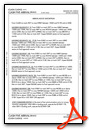
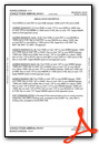
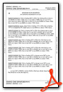
Weather Minimums

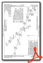
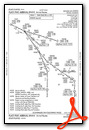
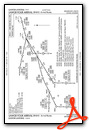
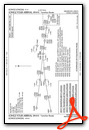
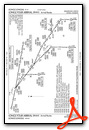
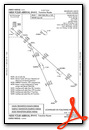
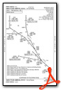
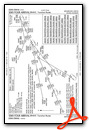
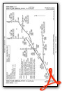
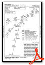
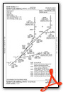
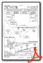
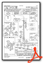
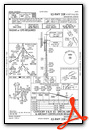
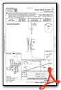
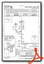
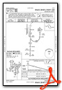
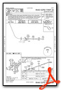
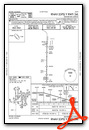
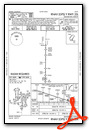
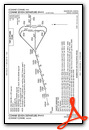
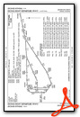
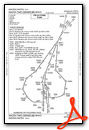
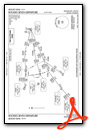
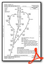
Standard Terminal Arrival (STAR) Charts
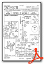
- AALLE FOUR (RNAV)

- AALLE FOUR (RNAV), CONT.1
- AALLE FOUR (RNAV), CONT.2
- CLASH FIVE (RNAV)

- CLASH FIVE (RNAV), CONT.1
- CLASH FIVE (RNAV), CONT.2
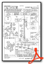
- DANDD ONE

- DANDD ONE, CONT.1

- FLATI FIVE (RNAV)
- FLATI FIVE (RNAV), CONT.1
- FLATI FIVE (RNAV), CONT.2

- LANDR THREE

- LANDR THREE, CONT.1

- LARKS THREE

- LARKS THREE, CONT.1

- LAWGR FOUR (RNAV)
- LAWGR FOUR (RNAV), CONT.1
- LAWGR FOUR (RNAV), CONT.2
- LONGZ FOUR (RNAV)
- LONGZ FOUR (RNAV), CONT.1
- LONGZ FOUR (RNAV), CONT.2
- NIIXX FOUR (RNAV)
- NIIXX FOUR (RNAV), CONT.1
- NIIXX FOUR (RNAV), CONT.2

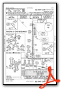
- POWDR ONE

- POWDR ONE, CONT.1

- QUAIL ONE

- RAMMS EIGHT

- RAMMS EIGHT, CONT.1

- SSKII FOUR (RNAV)
- SSKII FOUR (RNAV), CONT.1
- SSKII FOUR (RNAV), CONT.2

- TBARR FOUR (RNAV)
- TBARR FOUR (RNAV), CONT.1
- TBARR FOUR (RNAV), CONT.2
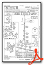
- TOMSN NINE

- TOMSN NINE, CONT.1

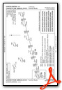
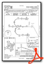
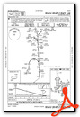
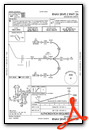
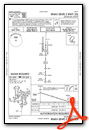
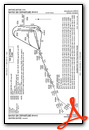
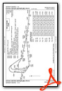
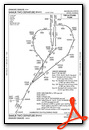
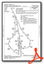
Instrument Approach Procedure (IAP) Charts
- ILS OR LOC RWY 07

- ILS OR LOC RWY 08

- ILS OR LOC RWY 16L

- ILS OR LOC RWY 16R
- ILS OR LOC RWY 17L
- ILS OR LOC RWY 17R
- ILS OR LOC RWY 25
- ILS OR LOC RWY 26
- ILS OR LOC RWY 34L
- ILS OR LOC RWY 34R

- ILS OR LOC RWY 35L
- ILS OR LOC RWY 35R

- ILS RWY 34L (SA CAT I)
- ILS RWY 34R (SA CAT I)

- ILS RWY 35L (SA CAT I)

- ILS RWY 35R (SA CAT I)
- ILS RWY 34L (CAT II - III)
- ILS RWY 34R (CAT II - III)
- ILS RWY 35L (CAT II - III)
- ILS RWY 35R (CAT II - III)
- RNAV (RNP) Z RWY 07
- RNAV (RNP) Z RWY 16L
- RNAV (RNP) Z RWY 16R
- RNAV (RNP) Z RWY 17L
- RNAV (RNP) Z RWY 17R

- RNAV (RNP) Z RWY 26
- RNAV (RNP) Z RWY 34L
- RNAV (RNP) Z RWY 34R
- RNAV (RNP) Z RWY 35L
- RNAV (RNP) Z RWY 35R
- RNAV (GPS) Y RWY 07

- RNAV (GPS) Y RWY 08
- RNAV (GPS) Y RWY 16L
- RNAV (GPS) Y RWY 16R

- RNAV (GPS) Y RWY 17L

- RNAV (GPS) Y RWY 17R

- RNAV (GPS) Y RWY 25

- RNAV (GPS) Y RWY 26
- RNAV (GPS) Y RWY 34L
- RNAV (GPS) Y RWY 34R

- RNAV (GPS) Y RWY 35L
- RNAV (GPS) Y RWY 35R

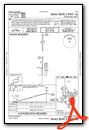
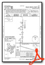
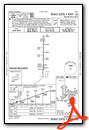
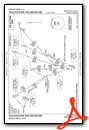
Departure Procedure (DP) Charts
- RNAV DP AAUP

- BAYLR SIX (RNAV)
- BAYLR SIX (RNAV), CONT.1

- CHUWY ONE (RNAV)

- CHUWY ONE (RNAV), CONT.1
- CONNR SEVEN (RNAV)
- CONNR SEVEN (RNAV), CONT.1

- COORZ SIX (RNAV)

- COORZ SIX (RNAV), CONT.1
- DDRTH ONE (RNAV)

- DDRTH ONE (RNAV), CONT.1

- DENVER THREE

- DENVER THREE, CONT.1
- EEONS EIGHT (RNAV)
- EEONS EIGHT (RNAV), CONT.1

- EMMYS EIGHT (RNAV)

- EMMYS EIGHT (RNAV), CONT.1
- EPKEE SEVEN (RNAV)

- EPKEE SEVEN (RNAV), CONT.1
- EXTAN SEVEN (RNAV)
- EXTAN SEVEN (RNAV), CONT.1
- HHOTH TWO (RNAV)
- HHOTH TWO (RNAV), CONT.1
- PIKES THREE

- PIKES THREE, CONT.1
- PLAINS TWO

- PLAINS TWO, CONT.1

- ROCKIES SEVEN
- ROCKIES SEVEN, CONT.1

- SABTH TWO (RNAV)

- SABTH TWO (RNAV), CONT.1
- SLEEK TWO (RNAV)

- SLEEK TWO (RNAV), CONT.1
- SMMUR TWO (RNAV)
- SMMUR TWO (RNAV), CONT.1

- SUDDZ ONE (RNAV)
- SUDDZ ONE (RNAV), CONT.1

- XXWNG ONE (RNAV)
- XXWNG ONE (RNAV), CONT.1
- YELLOWSTONE FIVE
- YELLOWSTONE FIVE, CONT.1
- ZIMMR THREE (RNAV)
- ZIMMR THREE (RNAV), CONT.1
Nearby Airports with Instrument Procedures
| ID | Name | Heading / Distance | ||
|---|---|---|---|---|
 |
KCFO | Colorado Air and Space Port Airport | 126° | 7.8 |
|
KBKF | Buckley Space Force Base Airport | 200° | 10.3 |
|
KAPA | Centennial Airport | 205° | 19.3 |
|
KEIK | Erie Municipal Airport | 297° | 19.5 |
|
KBJC | Rocky Mountain Metro Airport | 277° | 20.7 |
|
KLMO | Vance Brand Airport | 308° | 29.0 |
|
KGXY | Greeley-Weld County Airport | 003° | 34.6 |
|
KFNL | Northern Colorado Regional Airport | 336° | 38.7 |
|
KFMM | Fort Morgan Municipal Airport | 054° | 49.1 |
|
KFLY | Meadow Lake Airport | 174° | 55.3 |
|
KLIC | Limon Municipal Airport | 126° | 58.5 |
|
KGNB | Granby-Grand County Airport | 283° | 59.0 |
Airport Images
Do you have a recent image of this airport? Upload it here!


