Login
Register


AQP
Appleton Municipal Airport
Official FAA Data Effective 2026-02-19 0901Z
Chart Supplement

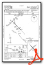
VFR Chart of KAQP
Sectional Charts at SkyVector.com
IFR Chart of KAQP
Enroute Charts at SkyVector.com
Location Information for KAQP
Coordinates: N45°13.65' / W96°0.27'Located 02 miles NE of Appleton, Minnesota on 220 acres of land. View all Airports in Minnesota.
Surveyed Elevation is 1021 feet MSL.
Operations Data
|
|
Airport Communications
| AWOS-3: | 118.5 Tel. 320-289-1265 |
|---|---|
| CTAF: | 122.900 |
| AWOS-3PT at BBB (16.2 E): | 118.45 320-843-3242 |
| AWOS-3 at DXX (16.2 SW): | 118.975 320-598-3863 |
| AWOS-3 at VVV (18.3 W): | 119.225 320-839-2363 |
- COMMUNICATIONS PRVDD BY PRINCETON RADIO ON FREQ 122.4 (MONTEVIDEO RCO).
- APCH/DEP SVC PRVDD BY MINNEAPOLIS ARTCC (ZMP) ON FREQS 127.1/290.2 (REDWOOD FALLS RCAG).
Nearby Navigation Aids
|
| ||||||||||||||||||||||||||||||||||||||||||||||||||||||


Runway 13/31
| Dimensions: | 3500 x 75 feet / 1067 x 23 meters | |
|---|---|---|
| Surface: | Asphalt in Fair Condition CRACKING. | |
| Edge Lighting: | Medium Intensity RY 13 VISUAL LIGHTING ON INSTRUMENT RY. | |
| Runway 13 | Runway 31 | |
| Coordinates: | N45°13.82' / W96°0.51' | N45°13.41' / W95°59.94' |
| Elevation: | 1020.0 | 1018.7 |
| Traffic Pattern: | Left | Left |
| Runway Heading: | 135° True | 315° True |
| Markings: | Non-Precision Instrument in good condition. | Non-Precision Instrument in good condition. |
Runway 04/22
CLOSED WINTER MONTHS. | ||
| Dimensions: | 2770 x 157 feet / 844 x 48 meters | |
|---|---|---|
| Surface: | Turf in Good Condition | |
| Runway 04 | Runway 22 | |
| Coordinates: | N45°13.54' / W96°0.56' | N45°13.86' / W96°0.10' |
| Elevation: | 1019.0 | 1021.0 |
| Traffic Pattern: | Left | Left |
| Runway Heading: | 45° True | 225° True |
| Markings: | Non-Standard in good condition. | Non-Standard in good condition. |
Services Available
| Fuel: | NONE |
|---|---|
| Transient Storage: | Tiedowns |
| Airframe Repair: | NONE |
| Engine Repair: | NONE |
| Bottled Oxygen: | NONE |
| Bulk Oxygen: | NONE |
| Other Services: | AIRCRAFT SALES |
Ownership Information
| Ownership: | Publicly owned | |
|---|---|---|
| Owner: | CITY OF APPLETON | |
| 323 W. SCHLIEMAN AVE. | ||
| APPLETON, MN 56208 | ||
| 320-289-1363 | ||
| Manager: | GREG RUETHER | |
| 149 S MUNSTERMAN | ||
| APPLETON, MN 56208 | ||
| (320) 413-0089 | ||
Other Remarks
- FOR CD CTC MINNEAPOLIS ARTCC AT 651-463-5588.
- MKD WITH YELLOW CONES.
- MKD WITH YELLOW CONES.
- ACTVT MIRL RY 13/31 - CTAF.
Weather Minimums


Instrument Approach Procedure (IAP) Charts
Nearby Airports with Instrument Procedures
| ID | Name | Heading / Distance | ||
|---|---|---|---|---|
 |
KBBB | Benson Municipal Airport | 067° | 16.3 |
|
KDXX | Lac Qui Parle County Airport | 207° | 16.2 |
|
KVVV | Ortonville Municipal/Martinson Field Airport | 284° | 18.4 |
|
KMVE | Montevideo-Chippewa County Airport | 141° | 19.9 |
|
KMOX | Morris Municipal/Charlie Schmidt Field Airport | 004° | 20.2 |
|
1D1 | Milbank Municipal Airport | 270° | 23.8 |
|
KCNB | Myers Field Airport | 200° | 31.9 |
|
KGDB | Granite Falls Municipal/Lenzen-Roe-Fagen Memorial Field Airport | 145° | 34.3 |
|
KBDH | Willmar Municipal/John L Rice Field Airport | 099° | 37.7 |
|
KGHW | Glenwood Municipal Airport | 048° | 38.2 |
|
KETH | Wheaton Municipal Airport | 325° | 40.2 |
|
Y63 | Elbow Lake Municipal/Pride of The Prairie Airport | 000° | 45.5 |
Airport Images
Do you have a recent image of this airport? Upload it here!


