Login
Register


Y63
Elbow Lake Municipal/Pride of The Prairie Airport
Official FAA Data Effective 2025-12-25 0901Z
Chart Supplement

VFR Chart of Y63
Sectional Charts at SkyVector.com
IFR Chart of Y63
Enroute Charts at SkyVector.com
Location Information for Y63
Coordinates: N45°59.17' / W95°59.14'Located 01 miles SW of Elbow Lake, Minnesota on 87 acres of land. View all Airports in Minnesota.
Surveyed Elevation is 1205 feet MSL.
RWY 11W/29W 794 FT AGL.
Operations Data
|
|
Airport Communications
| AWOS-3: | 118.075 Tel. 218-685-6456 |
|---|---|
| CTAF: | 122.900 |
| AWOS-3PT at FFM (19.1 N): | 119.05 218-736-7216 |
| AWOS-3PT at MOX (25.1 S): | 118.6 320-589-1303 |
| ASOS at AXN (25.7 E): | 118.375 320-763-7174 |
- APCH/DEP SVC PRVDD BY MINNEAPOLIS ARTCC ON FREQS 126.1/269.2 (ALEXANDRIA RCAG).
Nearby Navigation Aids
|
| ||||||||||||||||||||||||||||||||||||||||||||||||


Runway 11W/29W
CLSD SS-0700. | ||
| Dimensions: | 4127 x 130 feet / 1258 x 40 meters | |
|---|---|---|
| Surface: | Water | |
| Runway 11W | Runway 29W | |
| Coordinates: | N45°59.35' / W95°59.30' | N45°59.13' / W95°58.38' |
| Elevation: | 1185.0 | 1185.0 |
| Traffic Pattern: | Right | |
| Runway Heading: | 109° True | 289° True |
Runway 14/32
| Dimensions: | 3401 x 60 feet / 1037 x 18 meters | |
|---|---|---|
| Surface: | Asphalt in Fair Condition | |
| Weight Limits: | S-12 | |
| Edge Lighting: | Medium Intensity | |
| Runway 14 | Runway 32 | |
| Coordinates: | N45°59.31' / W95°59.77' | N45°58.87' / W95°59.26' |
| Elevation: | 1203.4 | 1200.5 |
| Traffic Pattern: | Left | Left |
| Runway Heading: | 140° True | 321° True |
| Markings: | Non-Precision Instrument in good condition. | Non-Precision Instrument in good condition. |
| Glide Slope Indicator | P4L (3.00° Glide Path Angle) | P4L (3.00° Glide Path Angle) |
| REIL: | Yes | Yes |
Services Available
| Fuel: | 100LL (blue) |
|---|---|
| Transient Storage: | Hangars,Tiedowns |
| Airframe Repair: | MAJOR |
| Engine Repair: | MAJOR |
| Bottled Oxygen: | LOW |
| Bulk Oxygen: | NONE |
| Other Services: | AIRCRAFT SALES |
Ownership Information
| Ownership: | Publicly owned | |
|---|---|---|
| Owner: | CITY OF ELBOW LAKE | |
| C/O CITY CLERK, PO BOX 1079 | ||
| ELBOW LAKE, MN 56531-1079 | ||
| 218-685-4483 | ||
| Manager: | JOE LARUE | |
| 1111 2ND ST SW | ||
| ELBOW LAKE, MN 56531-4214 | ||
| 218-685-6594 | ||
Other Remarks
- ULTRALIGHTS ON & INVOF ARPT.
- SEAPLANE OPS TO LAKE EAST OF ARPT MNT CTAF.
- FOR CD CTC MINNEAPOLIS ARTCC AT 651-463-5588.
- 0LL FUEL AVBL H24 SELF SVC VIA CREDIT CARD.
- ACTVT OR INCR INTST REIL RWY 14 & 32; PAPI RWY 14 & 32; MIRL RWY 14/32 - CTAF. MIRL RWY 14/32 PRESET LOW INTST.
- RWY 11W/29W 794 FT AGL.
Weather Minimums
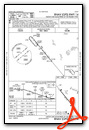
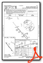
Instrument Approach Procedure (IAP) Charts
Nearby Airports with Instrument Procedures
| ID | Name | Heading / Distance | ||
|---|---|---|---|---|
 |
KFFM | Fergus Falls Regional Airport | 338° | 19.3 |
|
KMOX | Morris Municipal/Charlie Schmidt Field Airport | 178° | 25.4 |
|
KAXN | Alexandria Regional/Chandler Field Airport | 105° | 25.8 |
|
KETH | Wheaton Municipal Airport | 242° | 26.4 |
|
KBWP | Harry Stern Airport | 301° | 30.2 |
|
KGHW | Glenwood Municipal Airport | 126° | 34.7 |
|
16D | Perham Municipal Airport | 022° | 40.7 |
|
KBBB | Benson Municipal Airport | 160° | 41.7 |
|
KADC | Wadena Municipal Airport | 049° | 42.5 |
|
KVVV | Ortonville Municipal/Martinson Field Airport | 204° | 44.9 |
|
KAQP | Appleton Municipal Airport | 181° | 45.5 |
|
8D3 | Sisseton Municipal Airport | 246° | 46.4 |
Airport Images
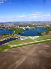
By: joe@prairie-air.net

By: bbf135


