



Login
Register
FA55
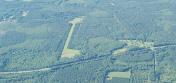
Garner Field Airport
Official FAA Data Effective 2026-10-01 0901Z
VFR Chart of FA55
Sectional Charts at SkyVector.com
IFR Chart of FA55
Enroute Charts at SkyVector.com
Location Information for FA55
Coordinates: N30°46.78' / W85°46.10'Located 05 miles E of Bonifay, Florida. View all Airports in Florida.
Estimated Elevation is 105 feet MSL.
Operations Data
|
|
Airport Communications
| ASOS at BCR (9.3 NE): | 119.825 850-949-3178 |
|---|---|
| AWOS-3P at 54J (20.1 W): | 118.725 850-892-0147 |
| ATIS at ECP (25.3 S): | 119.975 |
Nearby Navigation Aids
|
| ||||||||||||||||||||||||||||||||||||||||||||||||||||||||||||


Runway 18/36
| Dimensions: | 2650 x 100 feet / 808 x 30 meters | |
|---|---|---|
| Surface: | Turf | |
| Runway 18 | Runway 36 | |
Ownership Information
| Ownership: | Privately Owned | |
|---|---|---|
| Owner: | HOWARD E GARNER | |
| 3849 HWY 90 | ||
| BONIFAY, FL 32425 | ||
| (850) 326-3100 | ||
| Manager: | EDDIE GARNER | |
| 3849 HWY 90 | ||
| BONIFAY, FL 32425 | ||
| (850) 326-3100 | ||
Other Remarks
- FOR CD CTC CAIRNS APCH AT 334-255-8402 OR 334-255-8460, WHEN APCH CLSD CTC JACKSONVILLE ARTCC AT 904-845-1592.
Nearby Airports with Instrument Procedures
| ID | Name | Heading / Distance | ||
|---|---|---|---|---|
 |
KBCR | Tri-County Airport | 065° | 9.4 |
|
33J | Geneva Municipal Airport | 342° | 17.1 |
|
54J | Defuniak Springs Airport | 261° | 20.1 |
|
KECP | Northwest Florida Beaches International Airport | 183° | 25.3 |
|
KOZR | Cairns AAF (Fort Rucker) Airport | 005° | 29.8 |
|
KMAI | Marianna Municipal Airport | 083° | 30.5 |
|
KEDN | Enterprise Municipal Airport | 347° | 31.9 |
|
0J4 | Florala Municipal Airport | 299° | 32.1 |
|
KDHN | Dothan Regional Airport | 026° | 36.3 |
|
KCEW | Bob Sikes Airport | 270° | 39.0 |
|
KEGI | Duke Field,(Eglin Af Aux Nr 3) Airport | 258° | 39.8 |
|
71J | Ozark/Blackwell Field Airport | 010° | 39.8 |
Airport Images
By: smoody@motechsy...



