Login
Register


BCR
Tri-County Airport
Official FAA Data Effective 2026-01-22 0901Z
Chart Supplement

VFR Chart of KBCR
Sectional Charts at SkyVector.com
IFR Chart of KBCR
Enroute Charts at SkyVector.com
Location Information for KBCR
Coordinates: N30°50.63' / W85°36.10'Located 06 miles NE of Bonifay, Florida on 300 acres of land. View all Airports in Florida.
Surveyed Elevation is 86 feet MSL.
Operations Data
|
|
Airport Communications
| ASOS: | 119.825 Tel. 850-547-1431 |
|---|---|
| CAIRNS APPROACH: | 133.75 270.35 |
| CAIRNS DEPARTURE: | 133.75 270.35 |
| UNICOM: | 122.725 |
| CTAF: | 122.725 |
| ASOS at MAI (21.6 E): | 133.525 850-482-6082 |
| ATIS at OZR (26.6 N): | 111.2 |
| AWOS-3P at 54J (29.3 W): | 118.725 850-892-0147 |
- APCH/DEP SVC PRVDD BY JACKSONVILLE ARTCC ON FREQS 134.3/322.55 (DOTHAN RCAG) WHEN CAIRNS APCH/DEP CLSD.
Nearby Navigation Aids
|
| ||||||||||||||||||||||||||||||||||||||||||||||||||||||||||||


Runway 01/19
RWY SAFETY AREA CONTAINS MULT WASHOUTS WI FIRST 1000 FT BOTH SIDES. FENCE 252 FT E OF CNTRLN PENETRATES TRSNL SFC. | ||
| Dimensions: | 5398 x 75 feet / 1645 x 23 meters | |
|---|---|---|
| Surface: | Asphalt in Good Condition | |
| Weight Limits: | 21 /F/B/W/T, S-30 | |
| Edge Lighting: | Medium Intensity | |
| Runway 01 | Runway 19 | |
| Coordinates: | N30°50.19' / W85°36.19' | N30°51.07' / W85°36.02' |
| Elevation: | 86.0 | 84.0 |
| Runway Heading: | 10° True | 190° True |
| Markings: | Non-Precision Instrument in good condition. | Non-Precision Instrument in good condition. |
| Glide Slope Indicator | P2L (3.00° Glide Path Angle) | P2L (3.00° Glide Path Angle) |
| Obstacles: | 5 ft Brush 215 ft from runway, 115 ft right of center | 65 ft Trees 1490 ft from runway, 235 ft left of center |
Services Available
| Fuel: | 100LL (blue), Jet-A |
|---|---|
| Transient Storage: | Hangars,Tiedowns |
| Airframe Repair: | NONE |
| Engine Repair: | NONE |
| Bottled Oxygen: | NONE |
| Bulk Oxygen: | NONE |
| Other Services: | CROP DUSTING SERVICES,PILOT INSTRUCTION |
Ownership Information
| Ownership: | Publicly owned | |
|---|---|---|
| Owner: | TRI COUNTY AIRPORT AUTHORITY | CTC PERSON: JACK LOCKE |
| PO BOX 756 | ||
| BONIFAY, FL 32425 | ||
| 850-703-6808 | ||
| Manager: | MARK WILSON | |
| 1983 TRI COUNTY AIRPORT RD | ||
| BONIFAY, FL 32425 | ||
| 850-703-6808 | ||
Other Remarks
- WILDLIFE ON RWY; MIL OPS DALGT HR.
- FOR CD CTC CAIRNS APCH AT 334-255-8402, WHEN APCH CLSD CTC JACKSONVILLE ARTCC AT 904-845-1592.
- EXTSV SKYDIVING OPS ON WKENDS.
- TREES & FENCE FULL LEN OF RWY 01/19 252 FT TO 300 FT E OF CNTRLN PENTS THE TRANSITIONAL SFC OF RWY 01/19.
- TREES WIDTH OF RWY 252 FT FM RWY END 300 FT E OF CNTRLN PENETRATE TRSNL SFC.
- HILL 3553-3725 FT AFT APCH END 320-750 FT R OF CNTRLN PENETRATES TRSNL SFC.
- 0LL SELF SVC FUEL AVBL.
- ACTVT PAPI RWY 01 & 19; MIRL RWY 01/19 - CTAF.
Weather Minimums

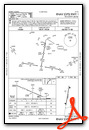
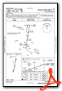
Instrument Approach Procedure (IAP) Charts
Nearby Airports with Instrument Procedures
| ID | Name | Heading / Distance | ||
|---|---|---|---|---|
 |
33J | Geneva Municipal Airport | 312° | 18.6 |
|
KMAI | Marianna Municipal Airport | 090° | 21.7 |
|
KOZR | Cairns AAF (Fort Rucker) Airport | 347° | 26.5 |
|
54J | Defuniak Springs Airport | 256° | 29.3 |
|
KDHN | Dothan Regional Airport | 015° | 29.6 |
|
KECP | Northwest Florida Beaches International Airport | 199° | 30.8 |
|
KEDN | Enterprise Municipal Airport | 330° | 31.3 |
|
KHDL | Headland Municipal Airport | 025° | 34.5 |
|
71J | Ozark/Blackwell Field Airport | 358° | 35.2 |
|
0J4 | Florala Municipal Airport | 288° | 38.5 |
|
17J | Donalsonville Municipal Airport | 075° | 38.6 |
|
KPAM | Tyndall AFB Airport | 178° | 46.4 |
Airport Images

By: KBCR_Manager


