Login
Register


35A
Union County, Troy Shelton Field Airport
Official FAA Data Effective 2026-01-22 0901Z
Chart Supplement

VFR Chart of 35A
Sectional Charts at SkyVector.com
IFR Chart of 35A
Enroute Charts at SkyVector.com
Location Information for 35A
Coordinates: N34°41.22' / W81°38.47'Located 01 miles SW of Union, South Carolina on 64 acres of land. View all Airports in South Carolina.
Surveyed Elevation is 609 feet MSL.
Operations Data
|
|
Airport Communications
| AWOS-3PT: | 119.45 Tel. 864-427-1514 |
|---|---|
| GREER APPROACH: | 119.4 350.2 |
| GREER DEPARTURE: | 119.4 350.2 |
| UNICOM: | 122.700 |
| CTAF: | 122.700 |
| AWOS-3 at LUX (18.6 SW): | 123.975 864-682-3639 |
| AWOS-3 at SPA (20.6 NW): | 133.925 864-587-2529 |
| AWOS-3 at DCM (22.8 E): | 120.975 803-385-2011 |
- APCH/DEP SVC PRVDD BY ATLANTA ARTCC ON FREQS 135.35/263.125 (OWING RCAG) WHEN APCH CTL CLSD.
Nearby Navigation Aids
|
| ||||||||||||||||||||||||||||||||||||||||||||||||||||||||||||


Runway 05/23
| Dimensions: | 3508 x 60 feet / 1069 x 18 meters | |
|---|---|---|
| Surface: | Asphalt in Good Condition | |
| Weight Limits: | S-12 | |
| Edge Lighting: | Medium Intensity | |
| Runway 05 | Runway 23 | |
| Coordinates: | N34°41.02' / W81°38.73' | N34°41.41' / W81°38.21' |
| Elevation: | 573.2 | 609.8 |
| Traffic Pattern: | Left | Left |
| Runway Heading: | 47° True | 227° True |
| Markings: | Non-Precision Instrument in good condition. | Basic in good condition. |
| Glide Slope Indicator | P2L (4.00° Glide Path Angle) | P2L (4.00° Glide Path Angle) |
| REIL: | Yes | |
Services Available
| Fuel: | 100LL (blue) |
|---|---|
| Transient Storage: | Hangars,Tiedowns |
| Airframe Repair: | MAJOR |
| Engine Repair: | MAJOR |
| Bottled Oxygen: | NONE |
| Bulk Oxygen: | NONE |
Ownership Information
| Ownership: | Publicly owned | |
|---|---|---|
| Owner: | UNION COUNTY | |
| PO DRAWER G | ||
| UNION, SC 29379 | ||
| 864-429-1600 | ||
| Manager: | RONNIE WADE | |
| UNION COUNTY AIRPORT, 198 AIRPORT RD | ||
| UNION, SC 29379 | ||
| 864-429-1680 | ||
Other Remarks
- FOR CD CTC GREER APCH AT 864-877-8275. WHEN GREER APCH CLSD, FOR CD CTC ATLANTA ARTCC AT 770-210-7692.
- 0LL SELF-SERVE FUEL AVBL 24 HRS. FOR SVC AFT HRS CALL 864-426-3003.
- REIL RWY 23 OPR PHOTOCELL. MIRL RWY 05/23 PRESET MED INTST DUSK-0000; AFTER 0000 ACTVT - CTAF. ACTVT PAPI RWY 05 & 23 - CTAF.
Weather Minimums

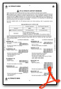
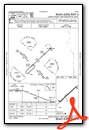
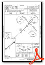
Instrument Approach Procedure (IAP) Charts
Nearby Airports with Instrument Procedures
| ID | Name | Heading / Distance | ||
|---|---|---|---|---|
 |
KLUX | Laurens County Airport | 234° | 18.6 |
|
KSPA | Spartanburg Downtown Memorial/Simpson Field Airport | 311° | 20.7 |
|
KEOE | Newberry County Airport | 179° | 22.6 |
|
KDCM | Chester Catawba Regional Airport | 074° | 22.9 |
|
KGSP | Greenville Spartanburg International Airport | 293° | 31.2 |
|
KUZA | Rock Hill/York County/Bryant Field Airport | 057° | 34.0 |
|
KEHO | Shelby-Cleveland County Regional Airport | 003° | 34.1 |
|
KFDW | Fairfield County Airport | 129° | 34.5 |
|
KGMU | Greenville Downtown Airport | 285° | 36.3 |
|
KGYH | Donaldson Field Airport | 276° | 36.6 |
|
KGRD | Greenwood County Airport | 224° | 36.6 |
|
KLKR | Lancaster County-Mc Whirter Field Airport | 086° | 39.0 |
Airport Images
Do you have a recent image of this airport? Upload it here!


