Login
Register


FME
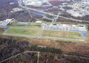
Fort Meade Exec Airport
Official FAA Data Effective 2026-01-22 0901Z
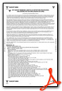
Chart Supplement

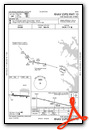
VFR Chart of KFME
Sectional Charts at SkyVector.com
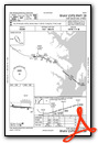
IFR Chart of KFME
Enroute Charts at SkyVector.com
Location Information for KFME
Coordinates: N39°5.12' / W76°45.57'Located 01 miles SW of Fort Meade (Odenton), Maryland on 366 acres of land. View all Airports in Maryland.
Estimated Elevation is 149 feet MSL.
Operations Data
|
|
Airport Communications
| AWOS-3: | 123.925 |
|---|---|
| POTOMAC APPROACH: | 119.7 290.475 |
| POTOMAC DEPARTURE: | 119.7 290.475 |
| UNICOM: | 123.050 |
| CTAF: | 123.050 |
| D-ATIS at BWI (6.9 NE): | 127.8 |
| ASOS at BWI (6.9 NE): | 227-217-0474 |
| AWOS-3 at CGS (9.9 SW): | 121.225 301-864-5497 |
Nearby Navigation Aids
|
| ||||||||||||||||||||||||||||||||||||||||||||||||||||||||||||


Runway 10/28
| Dimensions: | 3000 x 75 feet / 914 x 23 meters | |
|---|---|---|
| Surface: | Asphalt in Good Condition | |
| Edge Lighting: | Medium Intensity | |
| Runway 10 | Runway 28 | |
| Coordinates: | N39°5.14' / W76°45.88' | N39°5.10' / W76°45.25' |
| Elevation: | 119.7 | 149.5 |
| Traffic Pattern: | Right | Left |
| Runway Heading: | 94° True | 274° True |
| Markings: | Non-Precision Instrument in good condition. | Non-Precision Instrument in good condition. |
| Glide Slope Indicator | P2L (4.00° Glide Path Angle) PAPI UNUSBL BYD 8 DEGS LEFT & RIGHT OF CRS. | P2L (4.00° Glide Path Angle) PAPI UNUSBL BYD 5 DEGS LEFT OF CRS (TREES), AND 8 DEGS RIGHT OF CRS. |
| REIL: | Yes | Yes |
| Obstacles: | 60 ft Trees 1224 ft from runway, 150 ft left of center | |
Services Available
| Fuel: | 100LL (blue), Jet A+ |
|---|---|
| Transient Storage: | Tiedowns |
| Airframe Repair: | MINOR |
| Engine Repair: | MINOR |
| Bottled Oxygen: | NOT AVAILABLE |
| Bulk Oxygen: | NOT AVAILABLE |
| Other Services: | CHARTER SERVICE,PILOT INSTRUCTION,AIRCRAFT RENTAL |
Ownership Information
| Ownership: | Publicly owned | |
|---|---|---|
| Owner: | TIPTON ARPT AUTHORITY | |
| 7515 GENERAL AVIATION DRIVE | ||
| FT. MEADE, MD 20755 | ||
| 410-222-6815 | ||
| Manager: | MICHAEL A WASSEL | |
| 7515 GENERAL AVIATION DRIVE, SUITE 1 | ||
| FT. MEADE, MD 20755 | ||
| 410-222-6815 | ||
Other Remarks
- DEER ON RWY & TWY.
- BE ALERT FOR NMRS BWI TBJT ARR/DEP IN THE AREA. FLY TFC PATTERN SOUTH OF THE FIELD TO AVOID BWI CLASS B ASP. REMAIN CLEAR OF BWI CLASS B ASP UNTIL CLNC IS OBTAINED.
- PAEW ADJ ALL TWYS AND RWYS 10 & 28 INDEFLY.
- FOR CD CTC POTOMAC APCH AT 866-429-5882.
- RWY 10 & 28 REIL; MIRL RWY 10/28 ON PHOTOCELL DURING DALGT HRS.
- RWY 28 NOISE ABATEMENT PROC: OBSTS CLRD, FLY UPWIND TRK OF 265 DEGS TIL CLRNG TOWNHOMES.
- 0LL 24 HR SELF SVC 100LL AVBL WITH CREDIT CARD.
- 24 HR SELF SVC JET A+ AVBL WITH CREDIT CARD.
- ACTVT REIL RWY 10 & 28; PAPI RWY 10 & 28; MIRL RWY 10/28 - CTAF.
Weather Minimums

Instrument Approach Procedure (IAP) Charts
Nearby Airports with Instrument Procedures
| ID | Name | Heading / Distance | ||
|---|---|---|---|---|
 |
KBWI | Baltimore/Washington International Thurgood Marshall Airport | 037° | 6.9 |
|
W00 | Freeway Airport | 184° | 8.7 |
|
KCGS | College Park Airport | 230° | 9.9 |
|
KANP | Lee Airport | 133° | 12.4 |
|
KADW | Joint Base Andrews Airport | 197° | 17.2 |
|
KDCA | Ronald Reagan Washington Ntl Airport | 222° | 19.1 |
|
KGAI | Montgomery County Airpark Airport | 284° | 19.6 |
|
W50 | Davis Airport | 297° | 20.6 |
|
W29 | Bay Bridge Airport | 107° | 21.1 |
|
KMTN | Martin State Airport | 048° | 21.6 |
|
KVKX | Potomac Airfield Airport | 204° | 22.2 |
|
2W2 | Clearview Airpark Airport | 332° | 25.8 |
Airport Images
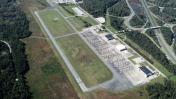
By: wkrozack
By: wkrozack


