Login
Register
GCK
Garden City Regional Airport
Official FAA Data Effective 2026-01-22 0901Z
VFR Chart of KGCK
Sectional Charts at SkyVector.com
IFR Chart of KGCK
Enroute Charts at SkyVector.com
Location Information for KGCK
Coordinates: N37°55.65' / W100°43.47'Located 08 miles SE of Garden City, Kansas on 1848 acres of land. View all Airports in Kansas.
Surveyed Elevation is 2890 feet MSL.
Operations Data
|
|
Airport Communications
| ASOS: | 121.325 Tel. 620-275-0803 |
|---|---|
| GARDEN CITY TOWER: | 118.15 254.4 |
| GARDEN CITY GROUND: | 119.0 254.4 |
| UNICOM: | 122.950 |
| CTAF: | 118.150 |
| AWOS-3PT at 36K (25.3 W): | 118.225 620-355-4004 |
| AWOS-3P at 19S (26.4 S): | 118.4 620-290-3873 |
| AWOS-3P at TQK (33.9 N): | 120.00 620-872-2233 |
- APCH/DEP CTL SVC PRVDD BY KANSAS CITY ARTCC (ZKC) ON FREQS 125.2/285.425 (GARDEN CITY RCAG).
Nearby Navigation Aids
|
| ||||||||||||||||||||||||||||||||||||||||||||||||||||||
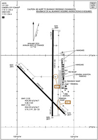
Runway 17/35
| Dimensions: | 7299 x 100 feet / 2225 x 30 meters | |
|---|---|---|
| Surface: | Concrete / Grooved in Good Condition | |
| Weight Limits: | S-76, D-91, ST-125
PCR VALUE: 270/R/D/W/T
| |
| Edge Lighting: | High Intensity | |
| Runway 17 | Runway 35 | |
| Coordinates: | N37°56.35' / W100°43.37' | N37°55.15' / W100°43.38' |
| Elevation: | 2888.6 | 2876.6 |
| Traffic Pattern: | Left | Left |
| Runway Heading: | 180° True | 0 |
| Declared Distances: | TORA:7299 TODA:7299 ASDA:7299 LDA:7299 | TORA:7299 TODA:7299 ASDA:7299 LDA:7299 |
| Markings: | Non-Precision Instrument in good condition. | Precision Instrument in good condition. |
| Glide Slope Indicator | V4L (3.00° Glide Path Angle) | V4L (3.00° Glide Path Angle) |
| Approach Lights: | MALSR 1,400 Foot Medium-intensity Approach Lighting System with runway alignment indicator lights. | |
| REIL: | Yes | |
Runway 12/30
| Dimensions: | 5700 x 100 feet / 1737 x 30 meters | |
|---|---|---|
| Surface: | Concrete in Good Condition | |
| Weight Limits: | S-48, D-60
PCR VALUE: 290/R/D/W/T
| |
| Edge Lighting: | Medium Intensity | |
| Runway 12 | Runway 30 | |
| Coordinates: | N37°55.85' / W100°44.00' | N37°55.18' / W100°43.16' |
| Elevation: | 2890.7 | 2877.4 |
| Traffic Pattern: | Left | Left |
| Runway Heading: | 135° True | 315° True |
| Declared Distances: | TORA:5700 TODA:5700 ASDA:5700 LDA:5700 | TORA:5700 TODA:5700 ASDA:5700 LDA:5700 |
| Markings: | Non-Precision Instrument in good condition. | Non-Precision Instrument in good condition. |
| Glide Slope Indicator | P2L (3.00° Glide Path Angle) | P2L (3.00° Glide Path Angle) |
| REIL: | Yes | Yes |
Services Available
| Fuel: | 100LL (blue), Jet-A |
|---|---|
| Transient Storage: | Hangars,Tiedowns |
| Airframe Repair: | MAJOR |
| Engine Repair: | MAJOR |
| Bottled Oxygen: | NONE |
| Bulk Oxygen: | LOW |
| Other Services: | CROP DUSTING SERVICES,CHARTER SERVICE,PILOT INSTRUCTION,AIRCRAFT RENTAL,AIRCRAFT SALES |
Ownership Information
| Ownership: | Publicly owned | |
|---|---|---|
| Owner: | CITY OF GARDEN CITY | |
| CITY HALL, BOX 499 | ||
| GARDEN CITY, KS 67846 | ||
| 620-276-1190 | ||
| Manager: | MS. RACHELLE POWELL | |
| 2225 S. AIR SERVICE RD. 112 | EMAIL: RACHELLE.POWELL@GARDENCITYKS.US | |
| GARDEN CITY, KS 67846 | ||
| 620-276-1190 | FAX 620-276-1192 | |
Other Remarks
- RY 35 DESIGNATED THE CALM WIND RY.
- AIR CARRIER OPS ARE NOT AUTHORIZED IN EXCESS OF 15 MINUTES BEFORE OR AFTER SCHEDULED ARRIVAL/DEPARTURE TIMES WITHOUT PRIOR COORDINATION WITH AMGR AND CONFIRMATION THAT ARFF IS AVBL PRIOR TO LDNG OR TKOF.
- IN THE EVENT OF AN AIR CARRIER DIVERSION OR OTHER IRREGULAR OPERATIONS EVENTS, AIRCRAFT OPERATORS SHOULD CONTACT AMGR 620-290-3810. FACILITY CONSTRAINTS INCLUDE: LACK OF INTERNATIONAL PASSENGER PROCESSING FACILITIES, LIMITED NUMBER OF PARKING POSITIONS AND LIMITED TERMINAL SPACE FOR PASSENGERS.
- ATCT BLIND SPOT ON THE NORTH TWY A HOLD BAY.
- FOR CD IF UNA TO CTC ON FSS FREQ, CTC KANSAS CITY ARTCC AT 913-254-8508.
- 0LL FOR MILITARY FUEL CALL 620-275-5055.
- ACTVT MIRL RY 12/30 & HIRL RY 17/35; REIL RYS 17; 12; 30 & MALSR RY 35 - CTAF. PAPI RYS 12 & 30 AND VASI RYS 17 & 35 ON 24 HRS.
Weather Minimums
Instrument Approach Procedure (IAP) Charts
Nearby Airports with Instrument Procedures
| ID | Name | Heading / Distance | ||
|---|---|---|---|---|
 |
KTQK | Scott City Municipal Airport | 347° | 33.7 |
 |
KULS | Ulysses Airport | 238° | 36.5 |
 |
KDDC | Dodge City Regional Airport | 105° | 37.4 |
 |
K79 | Jetmore Municipal Airport | 084° | 39.5 |
 |
KMEJ | Meade Municipal Airport | 155° | 42.7 |
 |
3K7 | Mark Hoard Memorial Airport | 317° | 43.4 |
 |
3K3 | Syracuse-Hamilton County Municipal Airport | 275° | 48.7 |
 |
48K | Ness City Municipal Airport | 049° | 50.6 |
 |
KJHN | Stanton County Municipal Airport | 247° | 52.2 |
 |
KLBL | Liberal Mid-America Regional Airport | 192° | 54.1 |
 |
KHQG | Hugoton Municipal Airport | 214° | 55.2 |
 |
5K2 | Tribune Municipal Airport | 303° | 57.8 |


Comments
Nice FBO
Nice airport and FBO. Fuel prices were very reasonable. The FBO staff was friendly and helpful. Sadly, the on-airport restaurant is no more, but a crew car was available to run into town for lunch. Lots of restaurant options available in town.