Login
Register


HQG
Hugoton Municipal Airport
Official FAA Data Effective 2026-01-22 0901Z
Chart Supplement

VFR Chart of KHQG
Sectional Charts at SkyVector.com
IFR Chart of KHQG
Enroute Charts at SkyVector.com
Location Information for KHQG
Coordinates: N37°9.80' / W101°22.24'Located 02 miles SW of Hugoton, Kansas on 214 acres of land. View all Airports in Kansas.
Surveyed Elevation is 3134 feet MSL.
Operations Data
|
|
Airport Communications
| AWOS-3PT: | 118.600 Tel. 620-544-4000 |
|---|---|
| CTAF: | 122.800 |
| UNICOM: | 122.800 |
| AWOS-3PT at LBL (21.2 E): | 118.375 620-624-1221 |
| AWOS-3P at EHA (26.3 W): | 118.025 620-697-4973 |
| AWOS-3PT at ULS (26.4 N): | 118.95 620-424-3747 |
- APCH/DEP CTL SVC PRVDD BY KANSAS CITY ARTCC (ZKC) ON FREQS 134.0/257.625 (LIBERAL RCAG).
Nearby Navigation Aids
|
| ||||||||||||||||||||||||||||||||||||||||||||||||||||||


Runway 02/20
| Dimensions: | 5000 x 75 feet / 1524 x 23 meters | |
|---|---|---|
| Surface: | Concrete in Fair Condition | |
| Weight Limits: | 11 /R/C/X/U, S-30 | |
| Edge Lighting: | High Intensity | |
| Runway 02 | Runway 20 | |
| Coordinates: | N37°9.33' / W101°22.47' | N37°10.08' / W101°22.04' |
| Elevation: | 3133.4 | 3129.7 |
| Traffic Pattern: | Left | Left |
| Runway Heading: | 25° True | 205° True |
| Markings: | Non-Precision Instrument in good condition. | Non-Precision Instrument in good condition. |
| Glide Slope Indicator | P2L (3.00° Glide Path Angle) | P2L (3.00° Glide Path Angle) |
| Obstacles: | 17 ft Road 758 ft from runway | 15 ft Road 613 ft from runway, 316 ft right of center |
Runway 13/31
| Dimensions: | 3039 x 60 feet / 926 x 18 meters | |
|---|---|---|
| Surface: | Asphalt in Good Condition | |
| Weight Limits: | 5 /F/C/Y/U | |
| Runway 13 | Runway 31 | |
| Coordinates: | N37°10.13' / W101°22.43' | N37°9.78' / W101°21.99' |
| Elevation: | 3129.4 | 3127.7 |
| Runway Heading: | 135° True | 315° True |
| Displaced Threshold: | 412 Feet | 202 Feet |
| Markings: | Basic in good condition. | Basic in good condition. |
| Obstacles: | 17 ft Road 503 ft from runway | |
Services Available
| Fuel: | 100LL (blue) |
|---|---|
| Transient Storage: | Hangars,Tiedowns |
| Airframe Repair: | NONE |
| Engine Repair: | NONE |
| Bottled Oxygen: | NONE |
| Bulk Oxygen: | NONE |
| Other Services: | CROP DUSTING SERVICES,PILOT INSTRUCTION |
Ownership Information
| Ownership: | Publicly owned | |
|---|---|---|
| Owner: | STEVENS COUNTY | |
| P.O. BOX 130 | ||
| HUGOTON, KS 67951 | ||
| 620-544-2541 | ||
| Manager: | SCOTT SPIKES | |
| BOX 130 | ||
| HUGOTON, KS 67951 | ||
| 620-544-7600 | ||
Other Remarks
- THIS AIRPORT HAS BEEN SURVEYED BY THE NATIONAL GEODETIC SURVEY.
- FOR CD CTC KANSAS CITY ARTCC AT 913-254-8508.
- ACTVT PAPI RWYS 02 & 20; HIRL RWY 02/20 - CTAF.
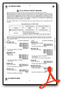
Weather Minimums

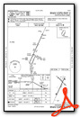
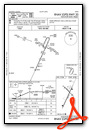
Instrument Approach Procedure (IAP) Charts
Nearby Airports with Instrument Procedures
| ID | Name | Heading / Distance | ||
|---|---|---|---|---|
 |
KLBL | Liberal Mid-America Regional Airport | 109° | 21.0 |
|
KEHA | Elkhart-Morton County Airport | 248° | 26.3 |
|
KULS | Ulysses Airport | 359° | 26.4 |
|
KGUY | Guymon Municipal Airport | 192° | 29.5 |
|
KJHN | Stanton County Municipal Airport | 325° | 30.6 |
|
KMEJ | Meade Municipal Airport | 081° | 49.1 |
|
3K3 | Syracuse-Hamilton County Municipal Airport | 340° | 53.2 |
|
KPYX | Perryton Ochiltree County Airport | 146° | 54.0 |
|
KGCK | Garden City Regional Airport | 033° | 55.2 |
|
E19 | Gruver Municipal Airport | 183° | 55.8 |
|
E42 | Major Samuel B Cornelius Field Airport | 171° | 57.1 |
|
17K | Boise City Airport | 247° | 59.6 |
Airport Images
Do you have a recent image of this airport? Upload it here!


Comments
NO Jet A available
There is no Jet A available at HQG.
JM
Admin