Login
Register


GRE
Greenville Airport
Official FAA Data Effective 2026-01-22 0901Z
Chart Supplement

VFR Chart of KGRE
Sectional Charts at SkyVector.com
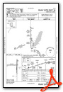
IFR Chart of KGRE
Enroute Charts at SkyVector.com
Location Information for KGRE
Coordinates: N38°50.17' / W89°22.73'Located 03 miles S of Greenville, Illinois on 492 acres of land. View all Airports in Illinois.
Surveyed Elevation is 540 feet MSL.
Operations Data
|
|
Airport Communications
| AWOS-2: | 120.0 Tel. 618-664-1939 |
|---|---|
| UNICOM: | 123.050 |
| CTAF: | 123.050 |
| AWOS-AV at VLA (13.5 NE): | 122.8 618-283-9595 |
| AWOS-3PT at SLO (22.6 SE): | 118.525 618-312-1051 |
| AWOS-3PT at ENL (23.5 SE): | 121.125 618-533-4417 |
- APCH/DEP SVC PRVDD BY KANSAS CITY ARTCC ON FREQS 124.3/269.15 (DECATUR RCAG)
Nearby Navigation Aids
|
| ||||||||||||||||||||||||||||||||||||||||||||||||||||||||||||


Runway 18/36
| Dimensions: | 4002 x 75 feet / 1220 x 23 meters | |
|---|---|---|
| Surface: | Asphalt in Good Condition | |
| Weight Limits: | S-7 | |
| Edge Lighting: | Medium Intensity | |
| Runway 18 | Runway 36 | |
| Coordinates: | N38°50.47' / W89°22.59' | N38°49.81' / W89°22.58' |
| Elevation: | 540.1 | 531.7 |
| Traffic Pattern: | Left | Left |
| Runway Heading: | 179° True | 359° True |
| Markings: | Non-Precision Instrument in fair condition. | Non-Precision Instrument in fair condition. |
| Glide Slope Indicator | PSIL (3.00° Glide Path Angle) | |
| REIL: | Yes | Yes |
Runway 09/27
| Dimensions: | 2822 x 250 feet / 860 x 76 meters | |
|---|---|---|
| Surface: | Turf in Good Condition | |
| Runway 09 | Runway 27 | |
| Coordinates: | N38°50.22' / W89°23.24' | N38°50.22' / W89°22.64' |
| Elevation: | 537.9 | 537.7 |
| Traffic Pattern: | Left | Left |
| Runway Heading: | 90° True | 270° True |
Services Available
| Fuel: | 100LL (blue), Jet-A |
|---|---|
| Transient Storage: | Hangars,Tiedowns |
| Airframe Repair: | NONE |
| Engine Repair: | NONE |
| Bottled Oxygen: | NONE |
| Bulk Oxygen: | NONE |
| Other Services: | GLIDER SERVICE,PILOT INSTRUCTION,PARACHUTE JUMP ACTIVITY,AIRCRAFT RENTAL,AIRCRAFT SALES,GLIDER TOWING SERVICES |
Ownership Information
| Ownership: | Publicly owned | |
|---|---|---|
| Owner: | THE GREENVILLE ARPT AUTHORITY | |
| 1374 SKY LANE | ||
| GREENVILLE, IL 62246 | ||
| 618-664-0926 | ||
| Manager: | LARRY KLEINER | |
| 1374 SKY LANE | ||
| GREENVILLE, IL 62246 | ||
| 618-664-0926 | OR 618-664-3272 | |
Other Remarks
- INTENSIVE PARACHUTE OPS.
- AWOS 3 CLICKS ON CTAF.
- DOOR CODE FOR BUILDING ENTRY IS CTAF, THEN #
- FOR CD CTC KANSAS CITY ARTCC AT 913-254-8508.
- MIRL RY 18/36 PRESET ON MED INTST; TO INCR INTST ACTVT - CTAF.
Weather Minimums

Instrument Approach Procedure (IAP) Charts

Nearby Airports with Instrument Procedures
| ID | Name | Heading / Distance | ||
|---|---|---|---|---|
 |
KVLA | Vandalia Municipal Airport | 046° | 13.6 |
|
KSLO | Salem-Leckrone Airport | 120° | 22.7 |
|
KENL | Centralia Municipal Airport | 144° | 23.5 |
|
3LF | Litchfield Municipal Airport | 324° | 24.0 |
|
KBLV | Scott AFB/Midamerica St Louis Airport | 231° | 27.6 |
|
KALN | St Louis Regional Airport | 276° | 31.4 |
|
KMVN | Mount Vernon Airport | 141° | 39.3 |
|
KCPS | St Louis Downtown Airport | 246° | 39.8 |
|
KTAZ | Taylorville Municipal Airport | 003° | 41.8 |
|
1H2 | Effingham County Regional Airport | 070° | 42.0 |
|
2H0 | Shelby County Airport | 035° | 42.5 |
|
KSAR | Sparta Community-Hunter Field Airport | 200° | 43.9 |
Airport Images

By: mkheck

By: mkheck


