Login
Register


3LF
Litchfield Municipal Airport
Official FAA Data Effective 2026-01-22 0901Z
Chart Supplement

VFR Chart of 3LF
Sectional Charts at SkyVector.com
IFR Chart of 3LF
Enroute Charts at SkyVector.com
Location Information for 3LF
Coordinates: N39°9.75' / W89°40.48'Located 02 miles SW of Litchfield, Illinois on 415 acres of land. View all Airports in Illinois.
Surveyed Elevation is 690 feet MSL.
Operations Data
|
|
Airport Communications
| AWOS-3PT: | 118.175 Tel. 217-324-4735 |
|---|---|
| SAINT LOUIS APPROACH: | 124.2 353.9 |
| SAINT LOUIS DEPARTURE: | 124.2 353.9 |
| CTAF: | 122.800 |
| UNICOM: | 122.800 |
| ATIS at ALN (23.8 SW): | 128.0 |
| AWOS-3PT at ALN (23.8 SW): | 128.0 618-259-7231 |
| AWOS-2 at GRE (24.3 SE): | 120.0 618-664-1939 |
Nearby Navigation Aids
|
| ||||||||||||||||||||||||||||||||||||||||||||||||||||||||||||


Runway 18/36
| Dimensions: | 4002 x 75 feet / 1220 x 23 meters | |
|---|---|---|
| Surface: | Asphalt in Good Condition | |
| Edge Lighting: | Medium Intensity | |
| Runway 18 | Runway 36 | |
| Coordinates: | N39°9.79' / W89°40.34' | N39°9.14' / W89°40.34' |
| Elevation: | 685.3 | 680.0 |
| Traffic Pattern: | Right | Left |
| Runway Heading: | 179° True | 359° True |
| Markings: | Non-Precision Instrument in fair condition. | Non-Precision Instrument in fair condition. |
| Glide Slope Indicator | P2L (3.00° Glide Path Angle) | P2L (3.00° Glide Path Angle) |
| REIL: | Yes | Yes |
Runway 09/27
| Dimensions: | 3900 x 75 feet / 1189 x 23 meters | |
|---|---|---|
| Surface: | Asphalt in Good Condition | |
| Edge Lighting: | Medium Intensity | |
| Runway 09 | Runway 27 | |
| Coordinates: | N39°10.04' / W89°41.03' | N39°10.04' / W89°40.21' |
| Elevation: | 681.9 | 689.9 |
| Traffic Pattern: | Right | Left |
| Runway Heading: | 90° True | 270° True |
| Markings: | Non-Precision Instrument in good condition. | Non-Precision Instrument in good condition. |
| Glide Slope Indicator | P2L (3.00° Glide Path Angle) | P2L (3.00° Glide Path Angle) |
| REIL: | Yes | Yes |
| Obstacles: | 14 ft Road 464 ft from runway, 289 ft left of center APCH RATIO 33:1 TO RY END FM OVER C.O. |
|
Services Available
| Fuel: | 100LL (blue), Jet-A |
|---|---|
| Transient Storage: | Hangars,Tiedowns |
| Airframe Repair: | MAJOR |
| Engine Repair: | MAJOR |
| Bottled Oxygen: | NOT AVAILABLE |
| Bulk Oxygen: | NOT AVAILABLE |
| Other Services: | CROP DUSTING SERVICES,PILOT INSTRUCTION,AIRCRAFT RENTAL,AIRCRAFT SALES |
Ownership Information
| Ownership: | Publicly owned | |
|---|---|---|
| Owner: | LITCHFIELD ARPT AUTH | BILL FLEMING, CHAIRMAN. |
| 1201 US ROUTE 66 SOUTH, P.O. BOX 381 | ||
| LITCHFIELD, IL 62056 | ||
| 217-324-6507 | ||
| Manager: | NICHOLAS WEATHERFORD | |
| 1201US ROUTE 66 SOUTH, P.O. BOX 381 | EMAIL ADDRESS: AIRPORT@LITCHFIELDIL.COM (ALL LOWER CASE) | |
| LITCHFIELD, IL 62056 | ||
| 217-556-4299 | ||
Other Remarks
- AEROBATIC AREA 1700 FT - 4200 FT MSL ABOVE ARPT.
- FOR CD CTC ST LOUIS APCH AT 314-890-1017.
- SELF SERV 100 LL FUEL AVAILABLE 24 HOURS.
- ACTVT REIL RWY 09, 27, 18 & 36; PAPI RWY 09, 27, 18 & 36; MIRL RWY 09/27 & 18/36; TWY LGTS - CTAF. MIRL RWY 18/36 & TWY C PRESET ON LOW INTST, TO INCR INTST & ACTVT - CTAF.
Weather Minimums


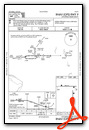
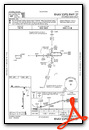
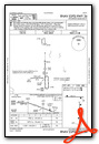
Instrument Approach Procedure (IAP) Charts

Nearby Airports with Instrument Procedures
| ID | Name | Heading / Distance | ||
|---|---|---|---|---|
 |
KALN | St Louis Regional Airport | 226° | 23.8 |
|
KGRE | Greenville Airport | 144° | 24.0 |
|
KVLA | Vandalia Municipal Airport | 113° | 25.9 |
|
KTAZ | Taylorville Municipal Airport | 035° | 27.4 |
|
KBLV | Scott AFB/Midamerica St Louis Airport | 191° | 37.8 |
|
KSET | St Charles County Regional/Smartt Field Airport | 248° | 38.0 |
|
KSTL | St Louis Lambert International Airport | 232° | 40.9 |
|
KSPI | Abraham Lincoln Capital Airport | 359° | 40.9 |
|
2H0 | Shelby County Airport | 068° | 41.4 |
|
KCPS | St Louis Downtown Airport | 212° | 42.0 |
|
KIJX | Jacksonville Municipal Airport | 324° | 45.1 |
|
KSLO | Salem-Leckrone Airport | 132° | 45.6 |


