Login
Register


GTE
Gothenburg Municipal Airport
Official FAA Data Effective 2025-12-25 0901Z
Chart Supplement

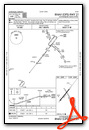
VFR Chart of KGTE
Sectional Charts at SkyVector.com
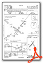
IFR Chart of KGTE
Enroute Charts at SkyVector.com
Location Information for KGTE
Coordinates: N40°55.53' / W100°8.79'Located 01 miles E of Gothenburg, Nebraska on 167 acres of land. View all Airports in Nebraska.
Estimated Elevation is 2558 feet MSL.
Operations Data
|
|
Airport Communications
| UNICOM: | 122.800 |
|---|---|
| CTAF: | 122.800 |
| AWOS-3 at LXN (18.7 SE): | 121.025 308-324-5975 |
| ASOS at LBF (26.4 NW): | 118.425 308-220-0580 |
| AWOS-3PT at CSB (37.1 S): | 118.375 308-697-4279 |
- APCH/DEP CTL SVC PRVDD BY DENVER ARTCC (ZDV) ON FREQS 132.7/226.675 (NORTH PLATTE RCAG).
Nearby Navigation Aids
|
| ||||||||||||||||||||||||||||||||||||||||||||||||


Runway 14/32
| Dimensions: | 3300 x 150 feet / 1006 x 46 meters | |
|---|---|---|
| Surface: | Turf in Good Condition | |
| Runway 14 | Runway 32 | |
| Coordinates: | N40°55.72' / W100°8.90' | N40°55.26' / W100°8.53' |
| Elevation: | 2555.0 | 2555.0 |
| Traffic Pattern: | Left | Left |
| Runway Heading: | 149° True | 329° True |
Runway 03/21
| Dimensions: | 2599 x 50 feet / 792 x 15 meters | |
|---|---|---|
| Surface: | Concrete in Good Condition | |
| Weight Limits: | S-28 | |
| Edge Lighting: | Medium Intensity | |
| Runway 03 | Runway 21 | |
| Coordinates: | N40°55.41' / W100°9.07' | N40°55.74' / W100°8.72' |
| Elevation: | 2556.0 | 2558.8 |
| Traffic Pattern: | Left | Left |
| Runway Heading: | 38° True | 218° True |
| Displaced Threshold: | 70 Feet | |
| Markings: | Non-Precision Instrument in good condition. | Non-Precision Instrument in good condition. |
| Obstacles: | 11 ft Other 279 ft from runway, 170 ft left of center OBSTN IS SEMI TRAILER, CLNC SLP IS 31:1 FM DEP THR. CTLG OBSTN FM DEP THR IS TWR 2157 FT OUT, 107 FT ABV, 514 FT R, CLNC SLP 20:1. |
19 ft Road 353 ft from runway, 273 ft right of center |
Services Available
| Fuel: | 100LL (blue) |
|---|---|
| Transient Storage: | Hangars,Tiedowns |
| Airframe Repair: | NOT AVAILABLE |
| Engine Repair: | NOT AVAILABLE |
| Bottled Oxygen: | NONE |
| Bulk Oxygen: | NONE |
Ownership Information
| Ownership: | Publicly owned | |
|---|---|---|
| Owner: | CITY OF GOTHENBURG | CHAIRMAN OF ARPT AUTH; ROGER TEDERMAN. |
| P.O. BOX 267 | ||
| GOTHENBURG, NE 69138-0267 | ||
| (308) 529-2594 | ||
| Manager: | GARY GREER | |
| P.O. BOX 267 | ||
| GOTHENBURG, NE 69138-0267 | ||
| 308-529-2594 | ||
Other Remarks
- RWY 14/32 NOT PLOWED WINTER MONTHS.
- MIGRATORY BIRDS INVOF APRT SPRING AND FALL.
- FOR CD CTC DENVER ARTCC AT 303-651-4257.
- 0LL FUEL AVBL H24 VIA CREDIT CARD.
- ACTVT MIRL RWY 03/21 - CTAF.
Weather Minimums
Instrument Approach Procedure (IAP) Charts

Nearby Airports with Instrument Procedures
| ID | Name | Heading / Distance | ||
|---|---|---|---|---|
 |
KCZD | Cozad Municipal Airport | 117° | 7.3 |
|
KLXN | Jim Kelly Field Airport | 115° | 18.7 |
|
47V | Curtis Municipal Airport | 221° | 22.7 |
|
KLBF | North Platte Regional/Lee Bird Field Airport | 296° | 27.2 |
|
KCSB | Cambridge Municipal Airport | 181° | 37.1 |
|
KBBW | Broken Bow Municipal/Keith Glaze Field Airport | 036° | 38.2 |
|
KHDE | Brewster Field Airport | 127° | 46.6 |
|
KMCK | Mc Cook Ben Nelson Regional Airport | 205° | 47.7 |
|
KEAR | Kearney Regional Airport | 102° | 53.3 |
|
0F4 | Loup City Municipal Airport | 067° | 56.7 |
|
0V3 | Pioneer Village Field Airport | 113° | 60.1 |
|
4D9 | Alma Municipal Airport | 142° | 61.0 |
Airport Images
Do you have a recent image of this airport? Upload it here!


