Login
Register


LBO
Floyd W Jones Lebanon Airport
Official FAA Data Effective 2026-01-22 0901Z
Chart Supplement

VFR Chart of KLBO
Sectional Charts at SkyVector.com
IFR Chart of KLBO
Enroute Charts at SkyVector.com
Location Information for KLBO
Coordinates: N37°38.90' / W92°39.15'Located 03 miles S of Lebanon, Missouri on 277 acres of land. View all Airports in Missouri.
Surveyed Elevation is 1320 feet MSL.
Operations Data
|
|
Airport Communications
| AWOS-3PT: | 118.975 Tel. 417-533-3419 |
|---|---|
| SPRINGFIELD APPROACH: | 121.1 290.5 |
| SPRINGFIELD DEPARTURE: | 121.1 290.5 |
| CLEARANCE DELIVERY: | 123.725 |
| UNICOM: | 122.800 |
| CTAF: | 122.800 |
| AWOS-3PT at OZS (19.7 N): | 120.225 573-233-1004 |
| ASOS at TBN (24.8 E): | 118.7 |
| D-ATIS at TBN (24.9 E): | 229.4 |
Nearby Navigation Aids
|
| ||||||||||||||||||||||||||||||||||||||||||||||||||||||


Runway 18/36
| Dimensions: | 5000 x 75 feet / 1524 x 23 meters | |
|---|---|---|
| Surface: | Asphalt in Excellent Condition | |
| Weight Limits: | S-33, D-54 | |
| Edge Lighting: | Medium Intensity | |
| Runway 18 | Runway 36 | |
| Coordinates: | N37°39.31' / W92°39.13' | N37°38.49' / W92°39.16' |
| Elevation: | 1305.7 | 1319.2 |
| Traffic Pattern: | Left | Left |
| Runway Heading: | 182° True | 2° True |
| Markings: | Non-Precision Instrument in good condition. | Non-Precision Instrument in good condition. |
| Glide Slope Indicator | P4L (3.00° Glide Path Angle) | P4L (3.00° Glide Path Angle) |
| REIL: | Yes | Yes |
| Obstacles: | 26 ft Trees 600 ft from runway, 300 ft right of center | |
Services Available
| Fuel: | 100LL (blue), Jet A-1+ |
|---|---|
| Transient Storage: | Hangars,Tiedowns |
| Airframe Repair: | MINOR |
| Engine Repair: | MINOR |
| Bottled Oxygen: | NONE |
| Bulk Oxygen: | NONE |
| Other Services: | CROP DUSTING SERVICES,CHARTER SERVICE,PILOT INSTRUCTION,AIRCRAFT RENTAL,AIRCRAFT SALES |
Ownership Information
| Ownership: | Publicly owned | |
|---|---|---|
| Owner: | CITY OF LEBANON | |
| PO BOX 111 | ||
| LEBANON, MO 65536 | ||
| 417-532-2156 | ||
| Manager: | MIKE WOOD | |
| PO BOX 111 | ||
| LEBANON, MO 65536 | ||
| (417) 532-7879 | ||
Other Remarks
- SPRAYER ACFT ON AND INVOF ARPT DURING SPRING AND SUMMER MONTHS.
- BIRDS, WILDLIFE ON & INVOF ARPT.
- FOR CD CTC SPRINGFIELD APCH AT 417-868-5620/5619.
- ACTVT REIL RWY 18 & 36; PAPI RWY 36; MIRL RWY 18/36 - CTAF.
Weather Minimums


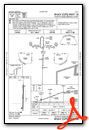
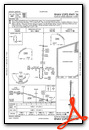
Instrument Approach Procedure (IAP) Charts
Nearby Airports with Instrument Procedures
| ID | Name | Heading / Distance | ||
|---|---|---|---|---|
 |
KOZS | Camdenton Memorial-Lake Regional Airport | 354° | 19.5 |
|
KTBN | Waynesville-St Robert Regional Forney Field Airport | 076° | 25.0 |
|
KAIZ | Lee C Fine Memorial Airport | 010° | 27.3 |
|
K15 | Grand Glaize-Osage Beach Airport | 357° | 27.7 |
|
M17 | Bolivar Municipal Airport | 264° | 33.3 |
|
1MO | Mountain Grove Memorial Airport | 152° | 35.6 |
|
M48 | Houston Memorial Airport | 120° | 37.6 |
|
3DW | Downtown Airport | 228° | 38.2 |
|
KAOV | Ava Bill Martin Memorial Airport | 182° | 40.6 |
|
KTVB | Cabool Memorial Airport | 138° | 41.2 |
|
KSGF | Springfield-Branson Ntl Airport | 235° | 42.7 |
|
H79 | Eldon Model Airpark Airport | 005° | 42.9 |
Airport Images
Do you have a recent image of this airport? Upload it here!


