Login
Register


OZS
Camdenton Memorial-Lake Regional Airport
Official FAA Data Effective 2025-11-27 0901Z
Chart Supplement

VFR Chart of KOZS
Sectional Charts at SkyVector.com
IFR Chart of KOZS
Enroute Charts at SkyVector.com
Location Information for KOZS
Coordinates: N37°58.36' / W92°41.43'Located 03 miles SE of Camdenton, Missouri on 192 acres of land. View all Airports in Missouri.
Surveyed Elevation is 1061 feet MSL.
Operations Data
|
|
Airport Communications
| AWOS-3PT: | 120.225 Tel. 573-233-1004 |
|---|---|
| MIZZU APPROACH: | 124.1 353.925 |
| MIZZU DEPARTURE: | 124.1 353.925 |
| CTAF: | 122.800 |
| UNICOM: | 122.800 |
| AWOS-3PT at AIZ (10.0 NE): | 135.325 573-348-0847 |
| AWOS-3PT at LBO (19.8 S): | 118.975 417-533-3419 |
| ASOS at TBN (29.3 SE): | 118.7 |
Nearby Navigation Aids
|
| ||||||||||||||||||||||||||||||||||||||||||||||||||||||


Runway 15/33
| Dimensions: | 5002 x 75 feet / 1525 x 23 meters | |
|---|---|---|
| Surface: | Asphalt in Excellent Condition | |
| Weight Limits: | 100/F/D/X/T, S-26, D-41 | |
| Edge Lighting: | Medium Intensity | |
| Runway 15 | Runway 33 | |
| Coordinates: | N37°58.74' / W92°41.65' | N37°57.99' / W92°41.21' |
| Elevation: | 1052.5 | 1049.8 |
| Traffic Pattern: | Left | Left |
| Runway Heading: | 155° True | 335° True |
| Markings: | Non-Precision Instrument in good condition. | Non-Precision Instrument in good condition. |
| Glide Slope Indicator | P4L (3.00° Glide Path Angle) | P4L (3.00° Glide Path Angle) |
| REIL: | Yes | Yes |
Services Available
| Fuel: | 100LL (blue), Jet A+ |
|---|---|
| Transient Storage: | Hangars,Tiedowns |
| Airframe Repair: | MAJOR |
| Engine Repair: | MAJOR |
| Bottled Oxygen: | LOW |
| Bulk Oxygen: | NONE |
| Other Services: | PILOT INSTRUCTION |
Ownership Information
| Ownership: | Publicly owned | |
|---|---|---|
| Owner: | CITY OF CAMDENTON | |
| 437 W US HWY 54 | ||
| CAMDENTON, MO 65020 | ||
| 573-346-3600 | ||
| Manager: | COREY LEUWERKE | |
| PO BOX 148 | ||
| CAMDENTON, MO 65020 | ||
| 573-346-0300 | ||
Other Remarks
- WILDLIFE ON & INVOF ARPT.
- FOR CD CTC MIZZOU APCH AT 417-868-5620/5619.
- ACTVT REIL RWYS 15 & 33; PAPI RWYS 15 & 33' AND MIRL RWY 15/33 - CTAF.
Weather Minimums


Instrument Approach Procedure (IAP) Charts
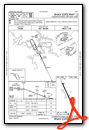
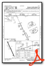

Nearby Airports with Instrument Procedures
| ID | Name | Heading / Distance | ||
|---|---|---|---|---|
 |
K15 | Grand Glaize-Osage Beach Airport | 003° | 8.3 |
|
KAIZ | Lee C Fine Memorial Airport | 042° | 10.0 |
|
KLBO | Floyd W Jones Lebanon Airport | 174° | 19.5 |
|
H79 | Eldon Model Airpark Airport | 013° | 24.0 |
|
KTBN | Waynesville-St Robert Regional Forney Field Airport | 117° | 29.6 |
|
KRAW | Warsaw Municipal Airport | 306° | 38.3 |
|
M17 | Bolivar Municipal Airport | 234° | 38.6 |
|
KVIH | Rolla Ntl Airport | 077° | 44.6 |
|
KJEF | Jefferson City Memorial Airport | 034° | 44.8 |
|
KDMO | Sedalia Regional Airport | 332° | 49.6 |
|
M48 | Houston Memorial Airport | 138° | 51.5 |
|
KGLY | Clinton Regional Airport | 296° | 52.1 |
Airport Images
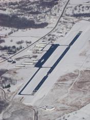
By: bcool


Comments
Great Stop!
Great airport and stop. Recently needed a restroom/rest stop on a long cross-country. Lake Aviation Center provided a much needed break. Arrived after hours, but, with a phone call was able to access the restrooms and pilot lounge. Thank you Lake Aviation Center--we'll back for a longer stay!
Paul Pillar
PA-28-180: N4375T
Senior Flight Test Engineer/Test Conductor
FAA Safety Team (FAAST) Representative
Civil Air Patrol Oklahoma Wing Director of Aerospace Education (DAE)
Great FBO and Service
I was on leg 2 of a 1000 mile cross country and had a minor aircraft issue. We made a provisional landing and they hauled us back and forth from the service hangar and terminal to avoid the walk in the hot sun. Amazingly friendly people. They helped to quickly diagnose and find the issue. It's well run operation and recommended even if you don't need aircraft service.