Login
Register


HUF
Terre Haute Regional Airport
Official FAA Data Effective 2026-02-19 0901Z
Chart Supplement

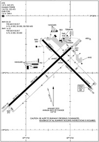
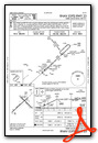
KHUF Airport Diagram
VFR Chart of KHUF
Sectional Charts at SkyVector.com
IFR Chart of KHUF
Enroute Charts at SkyVector.com
Location Information for KHUF
Coordinates: N39°27.04' / W87°18.42'Located 05 miles E of Terre Haute, Indiana on 1475 acres of land. View all Airports in Indiana.
Surveyed Elevation is 589 feet MSL.
Operations Data
|
|
Airport Communications
| ATIS: | 127.5 269.375 |
|---|---|
| ASOS: | 127.5 Tel. 812-877-7010 |
| HULMAN TOWER: | 134.725 322.475 |
| HULMAN GROUND: | 121.6 348.6 |
| HULMAN APPROACH: | 125.45 339.8 |
| HULMAN DEPARTURE: | 125.45 339.8 |
| EMERG: | 243.0 |
| UNICOM: | 122.950 |
| AWOS-3 at PRG (22.5 NW): | 124.175 217-465-4304 |
| AWOS-3PT at GPC (25.3 NE): | 118.125 765-653-1789 |
| AWOS-3 at RSV (30.6 SW): | 120.50 618-586-2772 |
Nearby Navigation Aids
|
| ||||||||||||||||||||||||||||||||||||||||||||||||||||||||||||


Runway 05/23
| Dimensions: | 9021 x 150 feet / 2750 x 46 meters 1000 FT PAVED BLAST PAD SW END & 1325 FT PAVED BLAST PAD NE END; RY 32 400 FT BY 150 FT BLAST PAD; NOT AVBL FOR ASDA. | |
|---|---|---|
| Surface: | Asphalt / Grooved in Fair Condition | |
| Weight Limits: | S-75, D-200, ST-300, DT-600
PCR VALUE: 450/F/D/X/T
| |
| Edge Lighting: | High Intensity | |
| Runway 05 | Runway 23 | |
| Coordinates: | N39°26.43' / W87°19.39' | N39°27.44' / W87°17.98' |
| Elevation: | 572.3 | 582.2 |
| Traffic Pattern: | Left | Left |
| Runway Heading: | 47° True | 227° True |
| Declared Distances: | TORA:9020 TODA:9020 ASDA:9020 LDA:9020 | TORA:9020 TODA:9020 ASDA:9020 LDA:9020 |
| Markings: | Precision Instrument in fair condition. | Precision Instrument in fair condition. |
| Glide Slope Indicator | P4L (3.00° Glide Path Angle) | P4L (3.00° Glide Path Angle) |
| RVR Equipment | Touchdown | Rollout |
| Approach Lights: | MALSR 1,400 Foot Medium-intensity Approach Lighting System with runway alignment indicator lights. | |
| REIL: | Yes | |
| Obstacles: | 54 ft Stack 2841 ft from runway, 412 ft left of center | 71 ft Tree 2297 ft from runway, 535 ft right of center |
Runway 14/32
| Dimensions: | 7200 x 150 feet / 2195 x 46 meters | |
|---|---|---|
| Surface: | Asphalt-Concrete / Grooved in Fair Condition | |
| Weight Limits: | S-75, D-200, ST-300
PCR VALUE: 650/F/D/X/T
| |
| Edge Lighting: | High Intensity | |
| Runway 14 | Runway 32 | |
| Coordinates: | N39°27.58' / W87°18.63' | N39°26.75' / W87°17.54' |
| Elevation: | 568.0 | 589.1 |
| Traffic Pattern: | Left | Left |
| Runway Heading: | 135° True | 315° True |
| Declared Distances: | TORA:7200 TODA:7200 ASDA:7200 LDA:7200 | TORA:7200 TODA:7200 ASDA:7200 LDA:7200 |
| Markings: | Non-Precision Instrument in good condition. | Non-Precision Instrument in good condition. |
| Glide Slope Indicator | P4L (2.75° Glide Path Angle) | P4L (3.00° Glide Path Angle) |
| REIL: | Yes | Yes |
| Obstacles: | 105 ft Tree 2597 ft from runway, 341 ft left of center | |
Services Available
| Fuel: | 100LL (blue), Jet-A |
|---|---|
| Transient Storage: | Hangars,Tiedowns |
| Airframe Repair: | MAJOR |
| Engine Repair: | MAJOR |
| Bottled Oxygen: | NONE |
| Bulk Oxygen: | NOT AVAILABLE |
| Other Services: | AIR FREIGHT SERVICES,CARGO HANDLING SERVICES,PILOT INSTRUCTION,AIRCRAFT RENTAL |
Ownership Information
| Ownership: | Publicly owned | |
|---|---|---|
| Owner: | TERRE HAUTE RGNL ARPT AUTH | |
| 581 S. AIRPORT ST. | ||
| TERRE HAUTE, IN 47803 | ||
| 812-877-2524 | ||
| Manager: | CRAIG MASCHINO | |
| 581 S. AIRPORT ST. | ||
| TERRE HAUTE, IN 47803 | ||
| 812-877-2524 | ||
Other Remarks
- BIRDS ON & INVOF ARPT.
- ACFT SVCS AVBL MON-SAT 0700-2100, SUN 0700-1900. FUEL AVBL AFTER HRS,SUBJECT TO AFTER HRS CALLOUT FEE.
- NO SERVICE ON HOLIDAYS
Weather Minimums

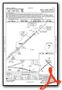
Instrument Approach Procedure (IAP) Charts


Nearby Airports with Instrument Procedures
| ID | Name | Heading / Distance | ||
|---|---|---|---|---|
 |
3I3 | Sky King Airport | 330° | 6.7 |
|
0I2 | Brazil Clay County/Charles B Hall Field Airport | 080° | 9.8 |
|
KSIV | Sullivan County Airport | 198° | 21.2 |
|
KPRG | Edgar County Airport | 311° | 22.5 |
|
KGPC | Putnam County Regional Airport | 064° | 25.4 |
|
KRSV | Crawford County Airport | 211° | 30.6 |
|
1H8 | Casey Municipal Airport | 254° | 33.6 |
|
KCFJ | Crawfordsville Regional Airport | 029° | 36.1 |
|
KBMG | Monroe County Airport | 119° | 37.0 |
|
2R2 | Hendricks County-Gordon Graham Field Airport | 065° | 42.5 |
|
KLWV | Lawrenceville-Vincennes International Airport | 198° | 43.4 |
|
KMTO | Coles County Memorial Airport | 272° | 45.2 |
Fuel Providers


We proudly offer fuel from:

US Dollar per US Gallon
Price Guaranteed by FBO


