Login
Register


2R2
Hendricks County-Gordon Graham Field Airport
Official FAA Data Effective 2026-01-22 0901Z
Chart Supplement

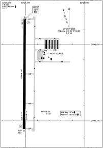
Airport Diagram
VFR Chart of 2R2
Sectional Charts at SkyVector.com
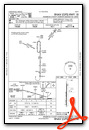
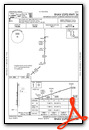
IFR Chart of 2R2
Enroute Charts at SkyVector.com
Location Information for 2R2
Coordinates: N39°44.81' / W86°28.51'Located 13 miles W of Indianapolis, Indiana on 239 acres of land. View all Airports in Indiana.
Surveyed Elevation is 897 feet MSL.
Operations Data
|
|
Airport Communications
| AWOS-3PT: | 118.025 Tel. 317-718-4872 |
|---|---|
| INDIANAPOLIS APPROACH: | 121.1 |
| INDIANAPOLIS DEPARTURE: | 119.05 |
| UNICOM: | 122.700 |
| CTAF: | 122.700 |
| D-ATIS at IND (8.5 E): | 134.25 |
| ASOS at IND (8.5 E): | 317-220-6243 |
| ASOS at EYE (9.7 NE): | 121.575 317-329-1754 |
Nearby Navigation Aids
|
| ||||||||||||||||||||||||||||||||||||||||||||||||||||||||||||


Runway 18/36
| Dimensions: | 4400 x 100 feet / 1341 x 30 meters | |
|---|---|---|
| Surface: | Asphalt in Good Condition | |
| Weight Limits: | S-125 | |
| Edge Lighting: | Medium Intensity | |
| Runway 18 | Runway 36 | |
| Coordinates: | N39°45.17' / W86°28.51' | N39°44.45' / W86°28.51' |
| Elevation: | 897.8 | 864.3 |
| Runway Heading: | 180° True | 0 |
| Markings: | Non-Precision Instrument in good condition. | Non-Precision Instrument in good condition. |
| Glide Slope Indicator | P2L (3.00° Glide Path Angle) | P2L (3.00° Glide Path Angle) |
| REIL: | Yes | Yes |
| Obstacles: | 25 ft Power Line 726 ft from runway, 230 ft left of center | |
Services Available
| Fuel: | 100LL (blue), Automotive Gasoline |
|---|---|
| Transient Storage: | Hangars,Tiedowns |
| Airframe Repair: | NOT AVAILABLE |
| Engine Repair: | NOT AVAILABLE |
| Bottled Oxygen: | NOT AVAILABLE |
| Bulk Oxygen: | NOT AVAILABLE |
| Other Services: | PILOT INSTRUCTION,AIRCRAFT RENTAL |
Ownership Information
| Ownership: | Publicly owned | |
|---|---|---|
| Owner: | INDIANAPOLIS AIRPORT AUTHORITY | |
| 7800 COL. H. WEIR COOK MEMORIAL DR., SUITE 100 | ||
| INDIANAPOLIS, IN 46241 | ||
| (317) 487-5022 | ||
| Manager: | KEITH BERLEN | |
| 7800 COL. H. WEIR COOK MEMORIAL DR., SUITE 100 | ||
| INDIANAPOLIS, IN 46241 | ||
| (317) 487-5022 | ||
Other Remarks
- MODEL ACFT ACT BLW 1 NM W OF RWY 18 THR BLW 400 FT.
- FOR CD CTC INDIANAPOLIS APCH AT 317-227-5743.
- ACFT TKOF/LDG FM RWY 18 DURG CALM WIND/XWIND CONDS; DURG ANY QUESTIONABLE PD RWY 18 SHALL BE PREFERRED RWY - CALL AMGR 317-487-9594.
- ACTVT REIL RWY 18 & 36; MIRL RWY 18/36 - CTAF. MIRL RWY 18/36 PRESET TO LOW INTST; INCR INTST - CTAF.
Weather Minimums

Instrument Approach Procedure (IAP) Charts
Nearby Airports with Instrument Procedures
| ID | Name | Heading / Distance | ||
|---|---|---|---|---|
 |
KIND | Indianapolis International Airport | 101° | 8.5 |
|
KEYE | Eagle Creek Airpark Airport | 058° | 9.8 |
|
KGPC | Putnam County Regional Airport | 246° | 17.1 |
|
KHFY | Indy South Greenwood Airport | 111° | 19.3 |
|
KTYQ | Indianapolis Exec Airport | 031° | 19.8 |
|
KUMP | Indianapolis Metro Airport | 060° | 22.9 |
|
KCFJ | Crawfordsville Regional Airport | 303° | 24.7 |
|
KMQJ | Indianapolis Regional Airport | 077° | 27.3 |
|
5I4 | Sheridan Airport | 024° | 28.5 |
|
KFKR | Frankfort Clinton County Regional Airport | 352° | 31.8 |
|
KGEZ | Shelbyville Municipal Airport | 107° | 32.6 |
|
0I2 | Brazil Clay County Airport | 240° | 33.2 |
Airport Images
Do you have a recent image of this airport? Upload it here!


