Login
Register


HUM
Houma-Terrebonne Airport
Official FAA Data Effective 2026-01-22 0901Z
Chart Supplement

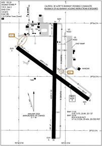
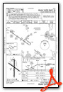
KHUM Airport Diagram
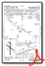
VFR Chart of KHUM
Sectional Charts at SkyVector.com
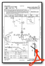
IFR Chart of KHUM
Enroute Charts at SkyVector.com
Location Information for KHUM
Coordinates: N29°33.99' / W90°39.63'Located 03 miles SE of Houma, Louisiana on 1813 acres of land. View all Airports in Louisiana.
Surveyed Elevation is 8 feet MSL.
Operations Data
|
|
Airport Communications
| ATIS: | 120.25 |
|---|---|
| AWOS-3PT: | 120.25 Tel. 985-876-4055 |
| HOUMA TOWER: | 125.3 346.3 |
| HOUMA GROUND: | 123.875 |
| NEW ORLEANS APPROACH: | 118.9 350.35 |
| NEW ORLEANS DEPARTURE: | 118.9 350.35 |
| CLEARANCE DELIVERY: | 118.9 ;WHEN TWR CLSD |
| EMERG: | 121.5 |
| CTAF: | 125.300 |
| UNICOM: | 122.950 |
| AWOS-3PT at 2LS (21.2 SE): | 118.175 985-475-5178 |
| AWOS-3PT at GAO (22.2 E): | 118.175 985-475-5178 |
| AWOS-3PT at APS (31.4 N): | 125.45 985-536-1009 |
Nearby Navigation Aids
|
| ||||||||||||||||||||||||||||||||||||||||||||||||||||||||||||


Runway 18/36
| Dimensions: | 6509 x 150 feet / 1984 x 46 meters | |
|---|---|---|
| Surface: | Concrete / Grooved in Good Condition | |
| Weight Limits: | 63 /R/B/W/T, S-116, D-224, ST-406, DT-907 | |
| Edge Lighting: | Medium Intensity | |
| Runway 18 | Runway 36 | |
| Coordinates: | N29°34.50' / W90°39.62' | N29°33.42' / W90°39.62' |
| Elevation: | 7.1 | 5.3 |
| Traffic Pattern: | Left | Left |
| Runway Heading: | 180° True | 0 |
| Declared Distances: | TORA:6508 TODA:6508 ASDA:6143 LDA:6143 | TORA:6508 TODA:6508 ASDA:6508 LDA:6508 |
| Markings: | Precision Instrument in good condition. | Precision Instrument in good condition. |
| Glide Slope Indicator | P2L (3.00° Glide Path Angle) | P2L (3.00° Glide Path Angle) |
| Approach Lights: | MALSR 1,400 Foot Medium-intensity Approach Lighting System with runway alignment indicator lights. | |
| REIL: | Yes | |
| Obstacles: | 77 ft Trees 3164 ft from runway | 54 ft Trees 2114 ft from runway |
Runway 12/30
| Dimensions: | 4999 x 185 feet / 1524 x 56 meters | |
|---|---|---|
| Surface: | Concrete in Good Condition | |
| Weight Limits: | S-50, D-70, ST-137 | |
| Edge Lighting: | Medium Intensity | |
| Runway 12 | Runway 30 | |
| Coordinates: | N29°34.27' / W90°40.02' | N29°33.79' / W90°39.25' |
| Elevation: | 4.8 | 8.0 |
| Traffic Pattern: | Left | Left |
| Runway Heading: | 125° True | 305° True |
| Declared Distances: | TORA:4999 TODA:4999 ASDA:4843 LDA:4843 | TORA:4999 TODA:4999 ASDA:4999 LDA:4999 |
| Markings: | Precision Instrument in fair condition. | Precision Instrument in good condition. |
| Glide Slope Indicator | P2L (3.00° Glide Path Angle) | P2L (3.00° Glide Path Angle) |
| REIL: | Yes | Yes |
| Obstacles: | 51 ft Trees 1353 ft from runway, 178 ft right of center | |
Services Available
| Fuel: | 100LL (blue), Jet-A |
|---|---|
| Transient Storage: | Hangars,Tiedowns |
| Airframe Repair: | MAJOR |
| Engine Repair: | MAJOR |
| Bottled Oxygen: | HIGH/LOW |
| Bulk Oxygen: | HIGH/LOW |
| Other Services: | AIR FREIGHT SERVICES,AIR AMBULANCE SERVICES,AVIONICS,CHARTER SERVICE,PILOT INSTRUCTION |
Ownership Information
| Ownership: | Publicly owned | |
|---|---|---|
| Owner: | HOUMA-TERREBONNE AIRPORT CMSN | CITY OF HOUMA AND TERREBONNE PARISH. |
| 10264 EAST MAIN ST | ||
| HOUMA, LA 70363 | ||
| 985-872-4646 | ||
| Manager: | ED JARVIS | |
| 10264 EAST MAIN ST | ||
| HOUMA, LA 70363 | ||
| 985-872-4646 | ||
Other Remarks
- BIRDS ON & INVOF ARPT. NUMEROUS BIRDS 500 FT AGL & BLO 2.8 NM SSW AER 36; AVOIDANCE ADVISED.
- RY 12/30 SFC SKID RESISTANCE FAIR WHEN WET
- EXTENSIVE HELICOPTER OPNS SOUTH THRU WEST OF ARPT.
- FOR CD WHEN ATCT IS CLSD CTC MSY APCH AT 504-471-4350 OR 118.9.
- 0LL FUEL AVBL 24 HRS WITH CREDIT CARD.
- ACTVT MALSR RWY 18; REIL RWY 12, 30 & 36; MIRL RWY 12/30 & 18/36 - CTAF.
Weather Minimums
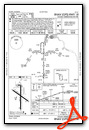
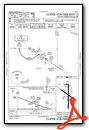
Instrument Approach Procedure (IAP) Charts


Nearby Airports with Instrument Procedures
| ID | Name | Heading / Distance | ||
|---|---|---|---|---|
 |
L83 | Thibodaux Municipal Airport | 320° | 14.1 |
|
KGAO | South Lafourche Leonard Miller Jr Airport | 109° | 22.2 |
|
KAPS | Port of South Louisiana Exec Regional Airport | 007° | 31.4 |
|
KMSY | Louis Armstrong New Orleans International Airport | 039° | 33.0 |
|
KPTN | Harry P Williams Memorial Airport | 283° | 36.5 |
|
KNBG | New Orleans NAS Jrb (Alvin Callender Field) Airport | 064° | 36.6 |
|
KREG | Louisiana Regional Airport | 338° | 39.0 |
|
KNEW | Lakefront Airport | 049° | 43.6 |
|
KHDC | Hammond Northshore Regional Airport | 012° | 58.5 |
|
KBTR | Baton Rouge Metro, Ryan Field Airport | 336° | 63.2 |
|
KASD | Slidell Airport | 042° | 64.0 |
|
KARA | Acadiana Regional Airport | 294° | 69.8 |
Airport Images
Do you have a recent image of this airport? Upload it here!


