Login
Register


PTN
Harry P Williams Memorial Airport
Official FAA Data Effective 2026-01-22 0901Z
Chart Supplement

VFR Chart of KPTN
Sectional Charts at SkyVector.com
IFR Chart of KPTN
Enroute Charts at SkyVector.com
Location Information for KPTN
Coordinates: N29°42.57' / W91°20.34'Located 02 miles NW of Patterson, Louisiana on 488 acres of land. View all Airports in Louisiana.
Surveyed Elevation is 8 feet MSL.
Operations Data
|
|
Airport Communications
| AWOS-3PT: | 134.575 Tel. 985-395-6735 |
|---|---|
| NEW ORLEANS APPROACH: | 124.3 350.35 |
| NEW ORLEANS DEPARTURE: | 124.3 350.35 |
| CLEARANCE DELIVERY: | 124.3 |
| UNICOM: | 122.800 |
| CTAF: | 122.800 |
| ASOS at ARA (34.5 NW): | 133.325 337-365-0128 |
| AWOS-3PT at REG (34.8 NE): | 121.175 225-644-4014 |
| ATIS at HUM (36.4 E): | 120.25 |
Nearby Navigation Aids
|
| ||||||||||||||||||||||||||||||||||||||||||||||||||||||||||||


Runway 06/24
| Dimensions: | 5399 x 150 feet / 1646 x 46 meters | |
|---|---|---|
| Surface: | Asphalt in Fair Condition | |
| Weight Limits: | S-32 | |
| Edge Lighting: | Medium Intensity | |
| Runway 06 | Runway 24 | |
| Coordinates: | N29°42.42' / W91°20.82' | N29°42.88' / W91°19.94' |
| Elevation: | 6.7 | 8.4 |
| Traffic Pattern: | Left | Right |
| Runway Heading: | 59° True | 239° True |
| Displaced Threshold: | 394 Feet | |
| Markings: | Non-Precision Instrument in fair condition. | Precision Instrument in fair condition. |
| Glide Slope Indicator | P2L (3.00° Glide Path Angle) | P2L (3.00° Glide Path Angle) |
| Approach Lights: | MALSR 1,400 Foot Medium-intensity Approach Lighting System with runway alignment indicator lights. | |
| REIL: | Yes | |
| Obstacles: | 58 ft Trees 1491 ft from runway, 262 ft left of center APCH RATIO 23:1 TO DTHR. |
|
Runway 04W/22W
| Dimensions: | 4500 x 100 feet / 1372 x 30 meters | |
|---|---|---|
| Surface: | Water in Good Condition | |
| Runway 04W | Runway 22W | |
| Coordinates: | N29°42.27' / W91°20.63' | N29°42.70' / W91°19.94' |
| Elevation: | 1.0 | 1.0 |
| Traffic Pattern: | Right | Left |
| Runway Heading: | 55° True | 235° True |
| Obstacles: | 20 ft Road 600 ft from runway | |
Services Available
| Fuel: | 100LL (blue), Jet-A |
|---|---|
| Transient Storage: | Hangars,Tiedowns |
| Airframe Repair: | MAJOR |
| Engine Repair: | MAJOR |
| Bottled Oxygen: | NONE |
| Bulk Oxygen: | NONE |
| Other Services: | CROP DUSTING SERVICES,AVIONICS,CHARTER SERVICE,PILOT INSTRUCTION |
Ownership Information
| Ownership: | Publicly owned | |
|---|---|---|
| Owner: | STATE OF LOUISIANA | |
| DOTD AVIATION SECTION, PO BOX 94245 | ||
| BATON ROUGE, LA 70804 | ||
| 225-379-3950 | ||
| Manager: | PAUL J. GOVERNAK | |
| 500 MAIN ST, 5TH FLOOR COURTHOUSE | ||
| FRANKLIN, LA 70538 | ||
| 337-828-4100 | ||
Other Remarks
- 4500 FT BY 100 FT WATERWAY HDG 04/22 LCTD 1100 FT SOUTH OF CONC RWY. DUAL LAND/SEA OPERATION.
- FOR CD CTC NEW ORLEANS APCH AT 504-471-4350 OR 124.3.
- PILOTS CONDUCTING EFVS OPS; BE AWARE LED ALS IN USE RWY 24.
- CTC ARPT MGR FOR DSNGD RAMP SPACE FOR PUB USE AT ARPT
- ACTVT MALSR RWY 24; MIRL RWY 06/24 PRESET MED INTST, TO INCR INTST - CTAF.
Weather Minimums
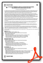
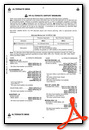
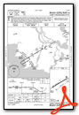
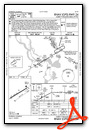
Instrument Approach Procedure (IAP) Charts

Nearby Airports with Instrument Procedures
| ID | Name | Heading / Distance | ||
|---|---|---|---|---|
 |
L83 | Thibodaux Municipal Airport | 084° | 26.5 |
|
KARA | Acadiana Regional Airport | 304° | 34.6 |
|
KREG | Louisiana Regional Airport | 036° | 34.6 |
|
KHUM | Houma-Terrebonne Airport | 103° | 36.5 |
|
KIYA | Abbeville Chris Crusta Memorial Airport | 292° | 42.0 |
|
KLFT | Lafayette Regional/Paul Fournet Field Airport | 311° | 45.0 |
|
KAPS | Port of South Louisiana Exec Regional Airport | 059° | 45.5 |
|
KBTR | Baton Rouge Metro, Ryan Field Airport | 011° | 50.3 |
|
KGAO | South Lafourche Leonard Miller Jr Airport | 105° | 58.6 |
|
KMSY | Louis Armstrong New Orleans International Airport | 072° | 58.9 |
|
KHZR | False River Regional Airport | 353° | 60.8 |
|
KOPL | St Landry Parish Airport | 322° | 64.4 |
Airport Images
Do you have a recent image of this airport? Upload it here!


