Login
Register
APS
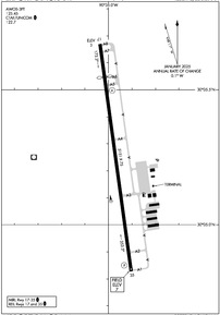
Port of South Louisiana Exec Regional Airport
Official FAA Data Effective 2025-12-25 0901Z
VFR Chart of KAPS
Sectional Charts at SkyVector.com
IFR Chart of KAPS
Enroute Charts at SkyVector.com
Location Information for KAPS
Coordinates: N30°5.25' / W90°34.97'Located 02 miles NW of Reserve, Louisiana on 285 acres of land. View all Airports in Louisiana.
Surveyed Elevation is 6 feet MSL.
Operations Data
|
|
Airport Communications
| AWOS-3PT: | 125.45 Tel. 985-536-1009 |
|---|---|
| NEW ORLEANS APPROACH: | 125.5 350.35 |
| NEW ORLEANS DEPARTURE: | 125.5 350.35 |
| CTAF: | 122.700 |
| UNICOM: | 122.700 |
| ASOS at MSY (16.8 E): | 504-471-4486 |
| D-ATIS at MSY (17.8 E): | 127.55 |
| AWOS-3PT at REG (19.3 W): | 121.175 225-644-4014 |
Nearby Navigation Aids
|
| ||||||||||||||||||||||||||||||||||||||||||||||||||||||||||||
Runway 17/35
| Dimensions: | 5151 x 75 feet / 1570 x 23 meters | |
|---|---|---|
| Surface: | Asphalt in Excellent Condition | |
| Edge Lighting: | Medium Intensity | |
| Runway 17 | Runway 35 | |
| Coordinates: | N30°5.67' / W90°35.04' | N30°4.83' / W90°34.90' |
| Elevation: | 3.1 | 6.5 |
| Traffic Pattern: | Right | |
| Runway Heading: | 172° True | 352° True |
| Displaced Threshold: | 746 Feet | |
| Markings: | Non-Precision Instrument in good condition. | Non-Precision Instrument in good condition. |
| Glide Slope Indicator | P2L (3.00° Glide Path Angle) | P2L (3.00° Glide Path Angle) |
| REIL: | Yes | Yes |
| Obstacles: | 75 ft Trees 1725 ft from runway APCH SLOPE 22:1 TO THE DSPLCD THLD. |
|
Services Available
| Fuel: | 100LL (blue), Jet-A, Jet A+ |
|---|---|
| Transient Storage: | Hangars,Tiedowns |
| Airframe Repair: | NONE |
| Engine Repair: | NONE |
| Bottled Oxygen: | NONE |
| Bulk Oxygen: | NONE |
| Other Services: | PILOT INSTRUCTION,AIRCRAFT RENTAL |
Ownership Information
| Ownership: | Publicly owned | |
|---|---|---|
| Owner: | PORT OF SOUTH LOUISIANA EXECUTIVE | |
| 171 BELLE TERRE | ||
| LAPLACE, LA 70068 | ||
| 985-652-9278 | FBO CTR 985-652-9278 #8512 OR 8510. | |
| Manager: | CHANSE P WATSON | |
| 355 AIRPORT ROAD | AIRPORT PHYS. ADDRESS: 355 AIRPORT RD., RESERVE, LA 70084 | |
| RESERVE, LA 70084 | ||
| 985-536-1999 | AFT HRS - 985-652-9278 EXT 1121 | |
Other Remarks
- ULTRALIGHT ACT.
- BIRDS ON AND INVOF ARPT.
- FOR CD CTC NEW ORLEANS APCH AT 504-471-4350.
- FOR TSNT GA CUSTOMERS NOT REQUIRING FBO SVC, PLEASE PARK N OF THE WHITE LINE.
- TWY A UNLIT.
- REIL RWY 17 & 35; MIRL RWY 17/35 PRESET LOW INTST; TO INCR INTST ACTVT - CTAF.
Weather Minimums
Instrument Approach Procedure (IAP) Charts
Nearby Airports with Instrument Procedures
| ID | Name | Heading / Distance | ||
|---|---|---|---|---|
 |
KMSY | Louis Armstrong New Orleans International Airport | 108° | 17.8 |
 |
KREG | Louisiana Regional Airport | 285° | 19.3 |
 |
L83 | Thibodaux Municipal Airport | 212° | 24.2 |
 |
KHDC | Hammond Northshore Regional Airport | 018° | 27.4 |
 |
KNEW | Lakefront Airport | 095° | 29.0 |
 |
KHUM | Houma-Terrebonne Airport | 187° | 31.4 |
 |
KNBG | New Orleans NAS Jrb (Alvin Callender Field) Airport | 118° | 32.9 |
 |
KBTR | Baton Rouge Metro, Ryan Field Airport | 312° | 39.7 |
 |
KGAO | South Lafourche Leonard Miller Jr Airport | 156° | 42.2 |
 |
KASD | Slidell Airport | 068° | 42.5 |
 |
KPTN | Harry P Williams Memorial Airport | 240° | 45.5 |
 |
KMJD | Picayune Municipal Airport | 063° | 54.0 |


