Login
Register


HYR
Sawyer County Airport
Official FAA Data Effective 2026-02-19 0901Z
Chart Supplement

VFR Chart of KHYR
Sectional Charts at SkyVector.com
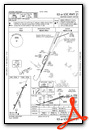
IFR Chart of KHYR
Enroute Charts at SkyVector.com
Location Information for KHYR
Coordinates: N46°1.52' / W91°26.66'Located 02 miles NE of Hayward, Wisconsin on 471 acres of land. View all Airports in Wisconsin.
Surveyed Elevation is 1215 feet MSL.
Operations Data
|
|
Airport Communications
| ASOS: | 118.4 Tel. 715-634-6138 |
|---|---|
| CTAF: | 122.800 |
| UNICOM: | 122.800 |
| AWOS-3 at OLG (23.3 NW): | 119.6 715-378-2031 |
| AWOS-3 at RCX (36.8 SE): | 118.125 715-609-1301 |
| ASOS at ASX (38.2 NE): | 126.775 715-682-5541 |
- APCH/DEP SVC PRVDD BY MINNEAPOLIS ARTCC ON FREQS 126.45/276.4 (HAYWARD RCAG).
Nearby Navigation Aids
|
| ||||||||||||||||||||||||||||||||||||||||||||||||||||||||||||


Runway 03/21
| Dimensions: | 5003 x 100 feet / 1525 x 30 meters | |
|---|---|---|
| Surface: | Asphalt / Grooved in Excellent Condition | |
| Weight Limits: | S-74, D-106, ST-173
PCR VALUE: 290/F/C/X/T
| |
| Edge Lighting: | High Intensity | |
| Runway 03 | Runway 21 | |
| Coordinates: | N46°1.18' / W91°26.90' | N46°1.93' / W91°26.41' |
| Elevation: | 1208.4 | 1215.8 |
| Traffic Pattern: | Left | Left |
| Runway Heading: | 25° True | 205° True |
| Markings: | Non-Precision Instrument in good condition. | Precision Instrument in good condition. |
| Glide Slope Indicator | P4L (3.00° Glide Path Angle) | P4R (3.00° Glide Path Angle) |
| Approach Lights: | MALSR 1,400 Foot Medium-intensity Approach Lighting System with runway alignment indicator lights. | |
| REIL: | Yes | |
| Obstacles: | 7 ft Fence 260 ft from runway, 500 ft left of center | 88 ft Trees 3200 ft from runway, 330 ft left of center |
Runway 16/34
CLSD DEC 1 - APR 15. | ||
| Dimensions: | 1088 x 120 feet / 332 x 37 meters | |
|---|---|---|
| Surface: | Turf in Fair Condition | |
| Runway 16 | Runway 34 | |
| Coordinates: | N46°1.44' / W91°26.70' | N46°1.27' / W91°26.62' |
| Elevation: | 1210.9 | 1209.7 |
| Traffic Pattern: | Left | Left |
| Runway Heading: | 163° True | 343° True |
| Obstacles: | 60 ft Trees 1030 ft from runway, 200 ft right of center | 53 ft Trees 700 ft from runway, 175 ft right of center |
Services Available
| Fuel: | 100LL (blue), Jet A+ |
|---|---|
| Transient Storage: | Hangars,Tiedowns |
| Airframe Repair: | NONE |
| Engine Repair: | NONE |
| Bottled Oxygen: | NONE |
| Bulk Oxygen: | NONE |
| Other Services: | PILOT INSTRUCTION,AIRCRAFT RENTAL |
Ownership Information
| Ownership: | Publicly owned | |
|---|---|---|
| Owner: | SAWYER COUNTY | |
| COURTHOUSE | ||
| HAYWARD, WI 54843 | ||
| 715-634-4866 | ||
| Manager: | DEREK LESLIE | |
| 10930 N ARPT RD | ||
| HAYWARD, WI 54843 | ||
| 715-634-4624 | ||
Other Remarks
- BIRDS ON & INVOF ARPT.
- ARPT COND UNMON 1700-0800.
- FOR CD IF UNA VIA FREQ CTC MINNEAPOLIS ARTCC AT 651-463-5588.
- YELLOW CONES.
- YELLOW CONES.
- ACTVT MALSR RWY 21; REIL RWY 03; PAPI RWY 03 & 21; HIRL RWY 03/21 - CTAF. SS-SR HIRL RWY 03/21 PRESET TO LOW; TO INCR INTST - CTAF.
Weather Minimums


Instrument Approach Procedure (IAP) Charts


Nearby Airports with Instrument Procedures
| ID | Name | Heading / Distance | ||
|---|---|---|---|---|
 |
3CU | Cable Union Airport | 038° | 13.1 |
|
KOLG | Solon Springs Municipal Airport | 318° | 23.3 |
|
KSSQ | Shell Lake Municipal Airport | 228° | 26.6 |
|
KRCX | Rusk County Airport | 149° | 36.8 |
|
KASX | John F Kennedy Memorial Airport | 034° | 38.3 |
|
KUBE | Cumberland Municipal Airport | 216° | 38.5 |
|
KRPD | Rice Lake Regional/Carl's Field Airport | 200° | 38.9 |
|
KRZN | Burnett County Airport | 253° | 40.8 |
|
KPKF | Park Falls Municipal Airport | 095° | 42.9 |
|
Y23 | Chetek Municipal/Southworth Airport | 190° | 43.9 |
|
KPBH | Price County Airport | 113° | 47.6 |
|
KSUW | Richard I Bong Airport | 326° | 48.2 |
Airport Images
Do you have a recent image of this airport? Upload it here!


