Login
Register


PBH
Price County Airport
Official FAA Data Effective 2026-01-22 0901Z
Chart Supplement

VFR Chart of KPBH
Sectional Charts at SkyVector.com
IFR Chart of KPBH
Enroute Charts at SkyVector.com
Location Information for KPBH
Coordinates: N45°42.53' / W90°24.15'Located 01 miles NW of Phillips, Wisconsin on 518 acres of land. View all Airports in Wisconsin.
Surveyed Elevation is 1497 feet MSL.
Operations Data
|
|
Airport Communications
| AWOS-3: | 125.875 Tel. 715-339-4520 |
|---|---|
| CTAF: | 122.800 |
| UNICOM: | 122.800 |
| AWOS-3 at RCX (28.2 SW): | 118.125 715-609-1301 |
| AWOS-3 at TKV (28.9 SE): | 118.250 715-453-5716 |
| AWOS-3 at ARV (31.0 NE): | 121.125 715-356-2417 |
- APCH/DEP SVC PRVDD BY MINNEAPOLIS ARTCC ON FREQS 133.65/281.5 (RHINELANDER RCAG).
Nearby Navigation Aids
|
| ||||||||||||||||||||||||||||||||||||||||||||||||||||||


Runway 01/19
| Dimensions: | 5220 x 75 feet / 1591 x 23 meters | |
|---|---|---|
| Surface: | Asphalt in Excellent Condition | |
| Weight Limits: | D-60 | |
| Edge Lighting: | Medium Intensity | |
| Runway 01 | Runway 19 | |
| Coordinates: | N45°42.26' / W90°24.21' | N45°43.11' / W90°24.06' |
| Elevation: | 1464.9 | 1497.0 |
| Runway Heading: | 7° True | 187° True |
| Markings: | Non-Precision Instrument in good condition. | Non-Precision Instrument in good condition. |
| Glide Slope Indicator | P2L (3.00° Glide Path Angle) | P2L (3.00° Glide Path Angle) |
| REIL: | Yes | Yes |
| Obstacles: | 58 ft Trees 1850 ft from runway, 300 ft right of center | |
Runway 06/24
| Dimensions: | 3951 x 75 feet / 1204 x 23 meters | |
|---|---|---|
| Surface: | Asphalt in Good Condition | |
| Weight Limits: | S-28, D-40 | |
| Edge Lighting: | Medium Intensity | |
| Runway 06 | Runway 24 | |
| Coordinates: | N45°42.16' / W90°24.57' | N45°42.50' / W90°23.78' |
| Elevation: | 1465.4 | 1472.0 |
| Traffic Pattern: | Left | Left |
| Runway Heading: | 59° True | 239° True |
| Markings: | Non-Precision Instrument in fair condition. | Non-Precision Instrument in fair condition. |
| Glide Slope Indicator | V2L (4.00° Glide Path Angle) | V2L (3.00° Glide Path Angle) |
| REIL: | Yes | |
| Obstacles: | 110 ft Trees 2070 ft from runway, 35 ft left of center | |
Services Available
| Fuel: | 100LL (blue), Jet A+, UL91 |
|---|---|
| Transient Storage: | Tiedowns |
| Airframe Repair: | MAJOR |
| Engine Repair: | NONE |
| Bottled Oxygen: | NONE |
| Bulk Oxygen: | NONE |
| Other Services: | PILOT INSTRUCTION |
Ownership Information
| Ownership: | Publicly owned | |
|---|---|---|
| Owner: | PRICE COUNTY | |
| 126 CHERRY ST. | ||
| PHILLIPS, WI 54555 | ||
| 715-339-3325 | ||
| Manager: | MICHAEL BRILL | |
| N1215 AIRPORT RD | ||
| PHILLIPS, WI 54555 | ||
| 715-339-3701 | ||
Other Remarks
- BIRDS ON & INVOF ARPT.
- FOR CD IF UNA TO CTC ON FSS FREQ, CTC MINNEAPOLIS ARTCC AT 651-463-5588.
- 0LL FUEL AVBL 24 HRS WITH CREDIT CARD.
- MIRL RWY 01/19 PRESET TO LOW SS-SR; TO INCR INTST & ACTVT REIL RWY 01, 19 & 24; PAPI RWY 01 & 19; VASI RWY 06 & 24; MIRL RWY 06/24 - CTAF.
Weather Minimums


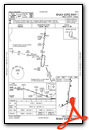
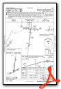
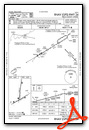
Instrument Approach Procedure (IAP) Charts

Nearby Airports with Instrument Procedures
| ID | Name | Heading / Distance | ||
|---|---|---|---|---|
 |
KPKF | Park Falls Municipal Airport | 356° | 14.8 |
|
KRCX | Rusk County Airport | 243° | 28.2 |
|
KTKV | Tomahawk Regional Airport | 119° | 29.0 |
|
KARV | Lakeland/Noble F Lee Memorial Field Airport | 064° | 31.1 |
|
D25 | Manitowish Waters Airport | 041° | 32.9 |
|
KMDZ | Taylor County Airport | 173° | 36.7 |
|
KRHI | Rhinelander/Oneida County Airport | 096° | 39.7 |
|
KRRL | Merrill Municipal Airport | 136° | 42.2 |
|
3CU | Cable Union Airport | 309° | 45.9 |
|
KHYR | Sawyer County Airport | 293° | 47.6 |
|
KEGV | Eagle River Union Airport | 073° | 49.4 |
|
KIWD | Gogebic/Iron County Airport | 012° | 50.4 |
Airport Images
Do you have a recent image of this airport? Upload it here!


